Tasmanian Trail TAS (480 km)
A wander through rural Tasmania
Starting location
- North to south – Devonport Ferry Terminal, Devonport, Tasmania
- South to north – Dover, Tasmania

Devonport start at the ferry terminal
Finish location
- North to south – Devonport Ferry Terminal, Devonport, Tasmania
- South to north – Dover, Tasmania
Best time to travel the Tasmanian Trail
- The best time to do this hike is between mid October to mid March due to the warmer temperatures, lower rainfalls and less likelihood of snow
- If travelling over summer (late November to late February), keep an eye on any potential fire risks along the trail as you would on any other hike at that time
- While you can do this trail over winter there are inherent risks:
- From around mid June to mid/late September there is a high likelihood of snowfalls on the higher sections of the trail and these may be reasonably heavy. Snow can even fall down to relatively low elevations of 300-400 metres. If you are experienced in hiking in the snow conditions and are prepared, then it’s possible
- What can also be an issue is the swollen river systems and given that you need to ford rivers this may require some creative route planning to avoid potentially dangerous river crossings
Trip Podcasts
If you want some additional information including on-trail recordings, have a listen to our series of podcasts on this trip:
- 191-Tasmanian Trail here I come
- In this episode we discuss my upcoming trip on the 480 km Tasmanian Trail including my concerns and expectations
- 192-Tasmanian Trail: week 1 on the trail
- This podcast episode consists of a series of recordings from Tim in his first week of the Tasmanian Trail. It was an interesting and challenging week that forced some route changes to due environmental conditions
- 193-Tasmanian Trail: week 2 on the trail
- This podcast episode consists of a series of recordings from Tim in his second week on the Tasmanian Trail. In addition to his on-trail recordings, Tim also discusses trail towns
- 194- A final wrap up
- In this episode we wrap up Tim’s 2021 Tasmanian Trail trip and while it ended prematurely it provided us with a great overview of what’s on offer outside of the very well known Tasmanian National Parks. In this episode also provide some suggestions about logistics and timing if you are keen to do this walk
Trip Posts
See my regular posts for this trip here
Trail background
The 480 km long Tasmanian Trail is Tasmania’s only long distance multi-use trail and is based on the mainland’s Bicentennial National Trail using similar trail markers. As a multi-use trail that caters for horse riders, cyclists and walkers, it bypasses the well known National Parks and relies heavily on management trails, roads and private property access. This trail passes through a number of small, and not so small, rural towns and provides a unique opportunity to see parts of Tasmania that aren’t on the typical tourist trails.
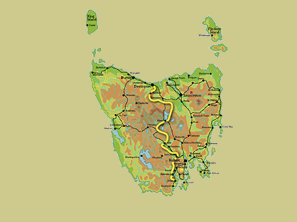
The Tasmanian Trail travels down the centre of the state

Typical trail marker on a street pole

Tasmanian Trail image on a forested section of the trail showing a trail marker on the tree at the right of this image
Tasmanian Trail
The Tasmanian Trail has been on my radar for a number of years and I decided, given the COVID situation which caused the cancellation of my planned hike, that Tasmania was a good option for a long distance hike so I started my journey in late July of 2021. While I had been to Tasmania in the past including to do the Overland Track I hadn’t really spent much time in the state and thought this would be a good opportunity to have a look around; in fact this trail pretty much runs down the centre of Tasmania. The first thing you need to know about the Tasmanian Trail is that it’s a multi-use trail designed for walkers, cyclists and horse riders, and as such really can’t be considered to be a ‘bushwalk’. Because it caters for horses, it bypasses Tasmania’s well known wilderness areas and National Parks and instead relies on a combination of state and private land in addition to sections of walking on road verges. So long as you go into this walk with that realisation then you won’t be disappointed with the lack of pristine wilderness which has instead been replaced with a tour of rural and regional Tasmania.
Logistics-wise is where this trip can become challenging. Flying in and out of Tasmania wasn’t as easy as in previous years with flights being limited or just downright impractical. I had the choice between the major airlines and the smaller operators with one option being an expensive 30 hour overnight trip via Brisbane or another with a stopover in Melbourne which, given COVID outbreaks, wasn’t a good place to be at that time. In the end I chose the direct flight from Canberra which then required me to get a bus to Devonport via Launceston (internal flights weren’t available at that time). All up my travel time from leaving Canberra to arriving at my hotel in Devonport was around 10 hours. I chose a motel relatively close to the trailhead as well as close to the outdoor stores so I could pick up stove gas first thing the next morning. Having said that, I managed to pick up gas in Hobart while waiting for the bus so I got away earlier than I had planned.
After a good nights sleep I grabbed a taxi from my hotel and got dropped off at the Devonport Ferry Terminal which is where the trail starts and was ready to start my walk at 8:30am. One disappointment here was that while I could easily find the trail markers spotting them on the taxi ride to the trailhead, there was no trail start sign. I’m finding that this is an issue on many trails around Australia and while I didn’t expect a big expensive pavilion there should at least be an obvious sign that says ‘trail starts here’.
The first part of the walk took me through the adjacent suburbs before following the Mersey River to the nearby town of Latrobe. I had originally thought about having an easy day and staying in Latrobe overnight however the main accomodation which is the caravan park appeared to be booked up. It wasn’t until I got to Latrobe that I found out that they are doing a winter refurbishment and opened up around 10 days after I started my walk. The other thing I discovered adjacent to the caravan park was a trailhead sign immediately adjacent to the horse paddock used by riders. While I managed to get a photo of this sign I couldn’t get close to it due to the soggy ground and drainage channel that would have required me to walk around 300 metres so I opted to avoid against a close up photo. Tasmania is a wet state with wintertime being the wet season. The winter of 2021 was also a very one and given the rainfall from the previous month, the ground was saturated. Using this paddock wouldn’t have been an option for horses at the time I past through – they would’ve been standing in water all night.
I hit Latrobe after a few hours of walking so decided to press on and camp but not before I took advantage of the local bakery for an early lunch. The trip out of Latrobe was through the residential area and then onto management road into the rural areas before walking through an extensive eucalyptus plantation. Potentially there were any number of campsites through the plantation but again it was too early to stop and I had decided to do 20 km for the day. I started to look for a campsite around 3:00pm and one comment that I would make here is that the road verges aren’t always a good option, often being too narrow and exposed to be suitable for camping. I pressed on and found a good spot that was around 50 metres off the road and hidden behind trees so I had a bit of privacy although I was surprised at the amount of traffic that used this road during the evening and into the night.
Day two saw me staying at Sheffield and given the rainfall and the forecast of 30-60 millimetres of rain over the next two days, I opted for a hotel stay. Another reason for this decision was that as you exit into Sheffield you walk along an access road that is also used by a local farmer and I managed to sink into mud and cow poo to above the height of my boot so decided I wanted a warm room to clean my socks and dry my boot of before heading out into what ws supposed to be a very rainy day. Sheffield is a biggish town with lots of eating options as well as accommodation and shopping choices. From an accomodation perspective this was the pattern I followed for the rest of the time on this trail, alternating between motels/hotels and tenting. Tents are cheaper and in most cases where you stay for the night is going to be free but given I had chosen the wettest time of the year to do this trip I appreciated a bit of luxury. In addition, I try to stay in commercial accomodation at least once a week to allow me to recharge my electronics and to edit and publish the podcast which tends to be a power hungry activity.
The pattern for this walk continued as I averaged walking around 20 km per day. Based on that I suggest you allow 24 days to do this trip plus any rest days you choose to add on which I try to do once a week, or as close as I possibly can. For this trail I would allow four weeks for a comfortable trip but if you can do the big distances, particularly during the warmer months you could easily shorten that. The trail tread for this walk consists of small amounts of hiking trail, management road and roadside walking given that it needs to be suitable for horses and cyclists as well as walkers.
Now let’s look at the trail itself. Because I chose to do this walk in July-August I was very much aware that snow and rainfall were potentially going to be an issue. I carefully monitored the Tasmanian webcams that focus on the central plateau lakes and watched as the days past with no snow and then seeing one day with around 70 cm snow in the morning around the alpine lakes and by the end of the day it all being washed away due to the rain. For me the water became the issue and while there are some designated detours that take you around the worst of the rivers if they’re in flood they don’t take you around all of them. I came across the Lobster Rivulet early in the trip and as a solo hiker I wasn’t game to cross it after testing it out. I may have been game in a group but even then it would have been touch and go. This Rivulet required me to backtrack and I ended up in the town of Deloraine for a break, to podcast and to decide what my options were.
From there on in I detoured any section that required fording a waterway and really, given the amount of rain that had fallen, there was no other option. This required me to do a fair bit of road walking and Tasmanian roads aren’t always designed for pedestrians so I found myself crossing back and forth to take the safest side of the road. This trail takes in a variety of different landscapes including temperate bushland, forests (both native and pine) and alpine plateaus. By no means is the landscape spectacular and I’d compare it to the vegetation on the Hume and Hovell Track in NSW which also bypasses many National Parks. I ended up doing the central plateau by car, partly due to time lost to detouring the flooded river systems, but also because I was travelling slower than planned which meant I wouldn’t have enough food to get me to my next resupply point. On the day that I traveled over the central plateau it was misty and raining slightly but there was no snow in sight.
Animal-wise this walk isn’t spectacular. I did see wallabies, the occasional potoroo and a variety of parrots that were new to me but again this walk isn’t about the wildlife unless you count cows. One bonus of walking at this time of the year was that I also didn’t see any snakes although I would expect that to change in the warmer months. Getting back to the wallabies the majority of wallabies I saw on this trail were roadkill in the drainage channels on the side of the road – I lost count of the number I came across but it was over 100!
As mentioned this isn’t a bushwalk but rather a journey through the Tasmanian rural countryside, taking in areas that most tourists would never usually visit and this is where you need to decide what sort of experience you’re seeking. Its never going to stack up against our well known hiking trails but if you want to see what’s on offer in rural Tasmania this is a great option.
Empty airport at Canberra for my flight to Hobart

Duffle bag packed and ready to go

Hobart for Lunch

Lots of leg room on the bus to Devonport
Trailhead at Devonport Ferry Terminal

Through the suburbs of Devonport

Walking to Latrobe

Epacris in flower

Caravan park at Latrobe

Trailhead sign at Latrobe

Access to eucalyptus plantation

Eucalyptus plantation

Fungus on the Tasmanian Trail

Trail lock – while hikers can get over the gate, the key made it much easier. Note the Tasmanian Trail logo on this lock

Road walking out of the eucalyptus plantation. There was a long section like this where camping wasn’t an option. It took around another 2 km before I found a suitable camping option

Cows interested in what I was doing. The cows on the northern end of the trail would come and see what I was up to and follow me along the fence for as long as they could. The cows further south were a bit more wary

Railton – a great spot for brunch
Leaving Railton on a shared trail

Sheffield Motor Inn

Mount Roland after leaving Sheffield

Riverside picnic area

Detour option early in the trail

Forest harvesting will change the landscape

Turnoff towards Lobster Rivulet

Another fungus on the Tasmanian Trail

Lobster Rivulet in flood. It’s deeper and stronger than it looks in the photo and forced me to rethink my route
In the photo above this water crossing doesn’t look that bad but the water was around 70 cm deep just off shore and when I threw a 25 kg sappling in I hadn’t seen anything move as fast. As a solo hiker I wasn’t game to test this out but in a group I may have been tempted. The water level had risen another 30 cm on top of this level by the next morning and this forced me to back track

Deloraine after backtracking from the Lobster Rivulet

Heading up to the Central Plateau. This area can be prone to snowfall

Hotel at Ouse

Shop and Post Office at Ouse

River at Ouse which was flooded requiring me to do a detour

Road walking out of Ouse

Campground out of Ouse

Campground out of Ouse

Sunset

Looking for a campsite

Off-trail campground

Road walking
I had just spent the last 15 minutes walking uphill into a 60 km per hour headwind so took a break. After I shot this video, the windspeed increased to around 80 km per hour before dropping off

Check in time although on the day I passed this sign there was no internet signal
This was the detour and in looking at the river, there would have been no way to cross further along without a bridge

Rural Tasmania

Campsite just off the road

A better campsite selection about 1 km further on – that’s just the luck of the draw

Town of Ellendale, Tasmania

Tyenna River at Westerway. Again I was supposed to cross this river further up and it wouldn’t have been an option

Bushy Park store

Derwent River

New Norfolk, Tasmania

Junction Motel, New Norfolk
Accomodation
This trip can be done in a number of ways as far as accomodation goes. You can choose to tent most of the way or do a combination of some nights in the tent and some nights in hotels. Expect to spend some nights in the tent if you are walking.
Campground out of Ouse on an alternate route to bypass a river crossing
Campground about 10 km out of Ouse. While there was a large area for tents to the right of this image it was pretty wet and boggy due to the heavy rains. This site is actually off-trail but I needed to bypass a river crossing and was a pleasant surprise given it had toilet facilities
Off-trail campground. The road is about 30-40 metres in the distance. There was another good choice about 500 metres on that also had internet signal
Caravan park at Latrobe. This facility was closed for renovation when I went through
Hotel at Ouse
Sheffield Motor Inn
The very quirky Junction Motel at New Norfolk!
Resupply
There are a number of options in regard to resupply on this trail and which one you choose is going to depend on your own personal preferences:
- Buy as you go
- There are a number of small, and not so small, towns along the trail and if you aren’t picky on your food selection you can buy a range of food as you go. Camping food is limited so you may find yourself buying from supermarkets along the trail. This is an option that never suits me for two reasons. Firstly I am really picky about my food and buying as I go means that I am likely to be buying food just for the sake of it and as a result am unlikely to eat well. Secondly after having a dietician look at my food choices I know what I use on a hike will keep me in reasonably good health over a period of multiple weeks
- Food caches/drops
- Dropping off food parcels along the hiking routs either to a store/hotel, or hiding in the bush is a workable option but will take about two days for a trip of this length. This may be an option if you live in Tasmania and can include having family or friends meeting you along the way with a resupply box
- Maildrops
- This is probably the best option to use for this or any other long distance trail from an Australian perspective. Australia Post does an excellent job with resupply and in all honesty its cheaper than doing food drops
For a detailed step by step look at Australian resupply options see our dedicated article here
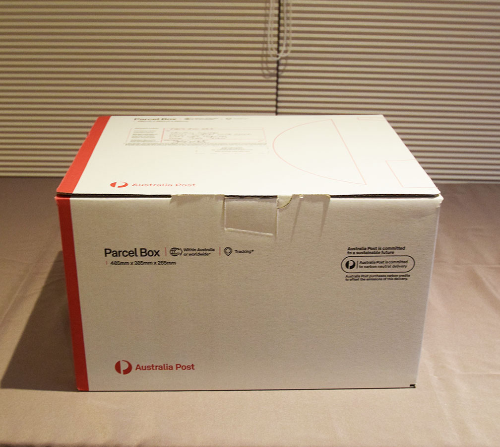
Resupply box ready to post

Chicken parmigiana from the Deloraine Hotel which was where I was staying. These are the typical big meals found at country hotels and would easily suit two people
Shop and Post Office at Ouse
Deloraine Deli – a great place for breakfast. Deloraine is around 7 km off-trail but worth a drop in for a rest day
Trail towns
The Tasmanian Trail passes directly though a number of towns of varying sizes in a addition to coming close to a number of others. Not only does this provide a potential source of review for these town but for the traveller it provides a good opportunity for a break from the trail. These trails towns fall into three broad categories and its worthwhile being aware of where each town sits:
- Bigger towns that rate a Woolworths supermarket. These are larger towns and these big supermarkets will provide good resupply opportunities and typically good accomodation and meal options
- Medium sized towns that rate an IGA supermarket and will have at least a basic range of accomodation and meal options
- Small towns that have a combined supermarket, post office and typically service station and takeaway. These towns provide limited resupply options
Railton – I stopped here for brunch on my second day of walking
New Norfolk, Tasmania
Things that you need to know before hiking the Tasmanian Trail
- Travelling from interstate with a heavy pack can increase your travelling costs substantially. In my case it doubled my airfare which still ended up being cheaper than the major airlines
- This trail can be done in either direction but the Trail Guide is designed and written to be done in a southwards direction starting in Devonport and given the flights out of Hobart are easier, heading south is a good option
- You need the Trail Guide (available for the Tasmanian Trail Association) to do this walk
- Having the GPX file (available from the Tasmanian Trail Association) loaded on your phone or GPS makes this walk much easier
- Arrange for a key delivery around three weeks out from the trip start. This key is provided by the Tasmanian Trail Association and costs $100 (you get an $80 refund when you return the key) and while it provides access to some gates (essential for horse riders) its main use is to access some toilet facilities along the trail
- The ability to do this trail without detours is very dependant on weather conditions i.e. snow and/or rainfall. Come prepared to be creative
- Be prepared for snow conditions throughout much of the year particularly in at higher altitudes particularly between June to October
- Be prepared for cold conditions during the winter months. Expect temperatures down to around -5° Celcius.
- Select your equipment based around the worst conditions that you are expecting
- You will be walking sections of road throughout this track
- Tasmanian roads aren’t always well suited to walking and many of the road shoulders are narrow requiring a change from side to side to provide distance between you and the traffic. I needed up walking on bitumen in some areas due to the road shoulders
- Water availability and quality on this trail is variable but usually reasonably good
- Carry enough water to last you for your planned distances for each day
- Study the GPX maps/Trail Guide and know where your water resupply points are
- Carry water purification tablets/drops, as well as a filter – sometimes it’s just easier to chemically dose the water
- The roadside channels are a good source of water but only use these if you have to and top up on water towards the top of a hill as almost without fail there is a dead wallaby, or two, further along
- Pay close attention to the private properties. There is no camping allowed on private land and if you just look at the distances you may find that your planned campsite isn’t an option
- Some property owners require you to make contact before entering their land so plan ahead
- Phone signal on much of the trail (on the Telstra network) is reasonably good. Often I would find that when I hit the top of the hill, the signal would appear. Internet signal is good but intermittent

Having a trail key allows you to open gates (important for horse riders) and to access some toilet facilities
Resources
- Tasmanian Trail Website
- Tasmanian Trail Facebook Page
- Tasmanian webcams
- Great for keeping an eye on snow conditions for the higher altitudes
Disclaimer
Sections of this trail were walked by Tim Savage from Australian Hiker