Three Capes Track TAS (48km)
Tasman National Park
Starting location
Port Arthur Jetty, Tasmania

Boat at the Port Arthur Jetty
Finishing location

Fortescue Bay, Tasmania – the end of the track
Track fees
As at 6 March 2025 the track fees are as follows:
- Adults AUD $615
- Concession card holders AUD $490
- Child (3-17) AUD $490
- Maximum of 2 infants under 3 years of age on track/day
- This track is recommended for those above 8 years of age
Tasmanian Government Trail Booking

Track permit that clips on your pack
Best time to travel the Three Capes Track
Year round
Being a coastal walk this trail is very different to the well known inland trails such as the Overland Track which can be inundated with snow during the colder months. The environment on the Three Capes Track is impacted by the ocean which surrounds this walk on three sides creating a much milder environment overall albeit a wind exposed one
Summertime daytime averages
- Maximum 19°C
- Minimum 16°C
Wintertime daytime averages
- Maximum 12°C
- Minimum 10°C
Map

Trail image for the Three Capes Track, Tasmania – 48km in total
- Image from https://www.threecapestrack.com.au

This screen shot shows the change in altitude over the four days on the trail (Source: Far Out app formerly Guthooks)
- Elevation gain – 1,110 metres
- Elevation loss – 1,112 metres
- Total grade – 9.3%
Nearest Town
Port Arthur, Tasmania
Trip Podcasts
If you want some additional information have a listen to the series of podcasts on this trip:
205-Three Capes Track, an introduction
- This is the first in the series of 3 podcast episodes released over 3 weeks on our trip on the Tasmanian Three Capes Track. In this episode we set the scene for trip and provide some background on what we expect. We hope you enjoy.
206-Three Capes Track, interviews from the trail
- This is the second episode in the series of 3 on the Tasmanian Three Capes Track. This episode consists of a series of on-trail recordings from Gill and I as we progress along the trail as well as interviews with other hikers who share their views.
207-Three Capes Track; Expectations versus reality
- In this third and final episode we compare our pre-trip expectations to the on-trail reality and our experiences, and make recommendations on how to get the best from this trip.
Our Trip
Hiking at Christmas has become a regular thing for Gill and I and in December 2021 we undertook a trip on the 48km Three Capes Track in Tasmania. We had been trying to do this walk for three years and for one reason or another we could never make it happen. In May 2021 we got our act together and booked ourselves in to start our walk on 24 December 2021 on the assumption that COVID would no longer be an issue. A month out things were looking good and Tasmania was scheduled to fully open up (with conditions) but in early December the latest strain of the virus took hold and it became a waiting game having to jump through a series of hurdles to get on-trail. After an anxious week we managed to make our way to Hobart and commence our walk.
The following write up will take you through this trip day by day and based on our experience we offer some suggestions on how to get the best from this experience. In addition, we have released a series of three related podcast episodes (see links below) that provide an alternative way of finding out more about this amazing trail.
The Lead Up
This trip was scheduled to start with a plane flight on 23 December and the actual walking to commence on 24 December. A month out from the walk start things were looking good with Australia opening up after 18 months of lockdowns across the country. A week out things started to go wrong and at one stage we thought that this trip would not happen. We watched as the latest strain of the Coronavirus spread throughout Australia and the rest of the world and doubt was thrown on whether the trip was still going to be on at all.
Finally our trip on the Three Capes Track has arrived and while Gill is still working this morning I’ve been doing the last minute sorting and working out which pack I was going to take. The website for this track recommends a 50 litre pack but after assembling all my gear I have managed to squeeze everything in to my 33 litre Osprey Talon Pack although given the option, a couple of extra litres space would have been appreciated and if I had the choice I would have opted for the next size up in this pack choosing a 36-40 litre pack. For many people this may not be an option and opting for such a small pack requires a fair degree of experience in determining what you need and what’s a luxury.
As usual the biggest bulk and weight impact on any trip is the food and once I lose that my pack will be half empty as I’m carrying two out of the four days worth of food (for two people). This is half of what I would usually carry and not having to carry a tent or sleeping mat has been a big reduction in my gear requirements. All up, my pack weighs around 12.5 kg including water which will be the lightest I have ever started a trip with. The rest of my day will be spent setting up the podcast and social media templates for the coming days to make my life a bit easier on the trail.
I usually start posting 100 days out from a trip start but given the COVID situation I wasn’t game and getting our negative COVID PCR tests (travel requirement) yesterday was the first time we have felt confident this trip would happen. We eventually ended up in Hobart checking into to our hotel and eventually making it to bed at around 11:00pm. Our choice of hotel was based on ensuring a very short walk to our bus to Port Arthur which we would board from Brooke Street Pier.

Waiting for our flight at the airport

Flying into Hobart

Moss Hotel in Hobart. We chose this hotel because we only had a 300 metre walk to the Brooke StreetPier to catch our bus in the morning
Day 1 Hobart - Port Arthur to Denmans Cove Trailhead (4km)
Today we start our walk on the Three Capes Track and what better way to start the day than with an early breakfast of corn and avocado fritters in Salamanca Place which is located close to the wharf area and metres from our chosen hotel. The weather is much cooler than Canberra at the moment which is finally getting temperatures over 30º Celsius and not my preferred hiking environment. This part of Tasmania has very pleasant temperatures and the Three Capes Track being a coastal walk is cool as summer walks go.
Back from breakfast now and onto the final packing before catching our bus to Port Arthur. Ideally I would have liked to catch the earlier boat but that was already booked up as far back as May when we booked this trip. The earlier boat provides opportunity to enjoy the beach but having said that there was never any way I was going to have a swim unless the water was much, much warmer or the air temperature was much hotter.
Our bus trip to Port Arthur was arranged by us and not part of the trip so we picked one of the companies recommended on the track website. What we didn’t realise was that the trip was actually a bit of a cultural tour so we had a history lesson on the way stopping in at Australia’s oldest bridge at Richmond as well as the scenic view in Pirates Bay.
We arrived at Port Arthur around 11:30am and our first stop was to drop into the rangers office to check in and pick up our track permit and guidebooks. One added bonus here is that the rangers office will store your unwanted bag(s) so any town clothes or other items can be held there for your return. There is also a locker room where you can store your pack while you wander around the Port Arthur historic site. One thing worth mentioning is that there is a long stay car park for Three Capes walkers so if you have your car with you and aren’t relying on buses then you can park your vehicle until your return.
From here we headed upstairs for lunch at the cafe before heading out to tour the site given we had a couple of hours until our boat trip across to the trailhead. I had never been to Port Arthur before so we spent time touring around and looking at the history associated with one of Australia’s historic convict sites. As part of your payment for this track you get entry into Port Arthur for two years and unless you come down the day before, a second visit is definitely on the cards.
There are two options for the boat trip to the trailhead at Denmans Cove, 11:30am and 2:00pm and we had the later timeslot, mainly because it was available when we booked in May. In the end this worked out well for us as it gave us time at Port Arthur and give we only had a 4km walk to Surveyors Hut later that afternoon, time wasn’t an issue. What we weren’t expecting was a tour of the bay taking in the wildlife and the scenery as well as the transfer to the trailhead. We hadn’t even started the walk yet and already this was turning into much more than we expected.
We arrived at Denmans Cove around 3:00pm and because the tide was so low we had to remove our shoes and socks for the short walk to the beach through about 40cm of water. After drying our feet off we made our way to the trailhead and away we went. As mentioned day 1 only requires a 4km walk but for some reason I hadn’t thought about the landscape we would be travelling through expecting to be walking along cliff tops on relatively flat ground. There are uphill sections and there is a steep incline which isn’t too bad but was totally unexpected. The walk while short provided great views and two encounters with echidnas on the edge of the track that weren’t too worried about the passing hikers. Even though it was summer there were also plenty of plants in flower and while this leg was only short it took us a while as I stopped to take photos on a regular basis. We came away thinking that even if the trip ended here we would have been happy.
The hut system on this trail is amazing and would probably rank as some of the best facilities in Australia. Each hut is built on the same design but takes advantage of the views and the landscape. Normally the huts are designed for 48 people but due to COVID the numbers had been reduced to 36 so we and another couple shared an 8 person cabin. In our case we were assigned cabin 1 and this assignment all the nights on the track so we knew what we were looking for when we turned up to the next facility. There are two seperate kitchens with water and gas cooking facilities, charging ports for your electronics, both open and undercover decking as well as raised composting toilets which also have hand basins and a mirror for your ablutions. In the case of Surveyors Hut, the toilets are around 50 metres away from the cabins.
After a briefing from the ranger, an early dinner, some socialising and some social media it was a relatively early bedtime which is typical for us on our hiking trips.

Breakfast of champions day 1 at Salamanca Square

Brooke Street Pier, Hobart. This was where we caught the bus to Port Arthur

Port Arthur historic site

Silent Prison Port Arthur

Exiting the boat at Denmans Cove

Trailhead marker at Denmans Cove for the Three Capes Track

Foot cleaning station to help halt the spread root rot

Echidna on the edge of the trail

Sun Orchid on the side of the track

Artwork on trail

Surveyors Hut, Three Capes Track

View across the dining room into the kitchen at Surveyors Hut

Hut toilets outside view

Inside view composting toilet
Day 2 Surveyors Hut to Munro Hut (11km)
Christmas Day! We always treat ourselves and bring small Christmas puddings and mince pies which makes for a great breakfast. This is the second day of hiking on the Three Capes Track and very different from yesterday leaving Surveyors Hut around 7:30am. Firstly, today’s walk totals 11km with our full packs and a real workout on the legs mainly due to the steep climb up Arthurs Peak and its adjacent sister Crescent Mountain. Arthurs Peak has some small switchbacks and then very long sets of stairs going back down.
This section of the trail was unique, something that would be the case in the following days, with the hero being the views and the vegetation as you crossed from coastal forest to heath and back into forest again before Munro Hut. The views from Arthurs Peak were amazing along the coastline to what are the tallest sea cliffs in the Southern Hemisphere. The views are at a distance and not really close up; that’s tomorrows walk. From Arthurs Peak we then had a climb up Crescent Mountain, which while taller was an easier ascent and descent. You can tell that this trail has been designed to be done in one direction and I would hate to do the reverse climb! We were surprised when we dropped into the viewing area at a lookout called Jurassic Crack and looked back to where we had come from and realised the sheer height of Arthurs Peak that we had previously walked up.
This section of the trail is where all the ontrail artwork starts and it’s good to see that in most cases it’s also functional seating. As mentioned the vegetation changed along the way and between the wildflowers and the views, it was enough to keep this happy snapper actively taking photos along the way.
We were first to arrive at Munro Hut (around 11:45am) as most people tended to seep later than us. We had the opportunity to talk with some hikers a day ahead of us to find out about their visit to Cape Pillar that morning. Munro Hut is a real crossover point because the previous day’s hikers are returning from Cape Pillar before heading on to Retakunna Hut and the new hikers, like us, arriving. Munro Hut is certainly the most scenic being adjacent to the cliffs and having marvellous views down to Cape Hauy and over the ocean. For us this hut was our favourite of the three as it just felt right with the ocean views and the surrounding vegetation. The one drawback about this hut is that the toilets are about 200-300 metres from the bunk rooms which means you are very much awake by the time you return to your sleeping bag after a late night dash! Apparently this was the first hut constructed along the trail and they were concerned that the smell from the toilets would be an issue. One big upside is that there are two outdoor showers with hotish water which you pour into a canvas bucket and stand underneath. This was very much appreciated by all!
The rest of the afternoon was spent lazing around, sun baking and just relaxing after the morning walking and so it was another early-ish night for us. Apparently the sunrise at this hut is the best on the trail and we intended to get up just before 5:00am to take advantage of that before getting an early start on the walk to Cape Pillar. I was up just after 4:00am and the stars were out but within 1/2 hour the clouds had rolled in and the rain had started so the sunrise viewing was off. We were geared to get up anyway so we had started walking just after 6:00am with the intent of having breakfast on the trail.

Tim and Gill Savage Christmas Day 2021

Wombat poo Sculpture and Seating

Boardwalk on the Three Capes Track

Cliff warning sign

View from Arthurs Peak

Going Down

Steps on the Three Capes Track

Moss on a tree

Sign to Munro Hut

Lookout at Munro Hut, looking towards Cape Hauy which is our day 4 walk

One of two open air showers at Munro Hut

Helicopter landing pad at Munro Hut. This is apparently the best place on the trail to view sunrises
Day 3 Cape Pillar and the 'Blade' (19km)
Today was all about what is supposed to be the highlight of this trip and that’s the walk down to Cape Pillar and the Blade. As has been the case at the previous hut we had an evening briefing from the host ranger who outlined amongst other things what’s happening the next day. The main thing we wanted to know was about the trip to Cape Pillar. Because of the crossover with our group and the incoming group we needed to fully pack up and carry our main packs down to the small shed located not far from the cabin and head out to Cape Pillar with a small day pack.
You start the walk with your main pack and about 100 metres in there is a gear storage shed to drop off your main pack and continue on with a small day pack. The serious rain had stopped by the time we started but it was still heavy enough that we needed our rain gear. A word of warning here that this is Tasmania, it will rain at some point so bring the rain gear. Today was also very windy and as we made our way our to our destination, mainly on boardwalk the winds picked up in intensity as we lost the protection from the surrounding hills. At one stage we reached an artwork called Wicked Winds which is a warped bench designed to look like the wind blasted vegetation and just as we past it I was almost blown sideways by a concentrated gust of wind that hit me just at the wrong time. It’s well and truly away from the cliff edge but made us a bit more conservative when we reached the more exposed areas.
We ended up getting to the Blade which is a narrow rock ridge that officially stops around half way up but if you feel happy with a high degree of exposure then there is a narrower path right up to the summit. It’s called the Blade because the ridge is narrow and everyone that we talked to both on this day and later in the trip said that they felt very exposed. We didn’t get right up to the top because the 40km per hour winds blowing sideways across this narrow ridge which didn’t make us feel comfortable. Hikers that arrived about 50 minutes after we did drew the lucky card as the winds dropped and the sun came out and while this didn’t last long the conditions were good enough to reach the high point. We continued on from here stopping in at a lookout called Seal Spa; or at least that was the name attributed to the artwork here and this provided some excellent views to nearby Tasman Island with the big highlight being the hexagonal shaped rocks. Back onto the main trail again and we walked past the Chasm which as the name describes is a gap in the rocks that drops down providing some very unique views before reaching the Cape Pillar lookout. While the views at Cape Pillar were good they didn’t come close to Seal Spa.
We then headed back to Munro Hut passing our fellow hikers on the way. We picked up our pacs and had some lunch prior to starting our journey to Retakunna Hut. All up from start to finish we took around 6.5 hours to cover the 19km from Munro hut out to Cape Pillar and finish off at Retakunna Hut. This is the longest day of the trip but the majority of the walking is with a daypack and given that I was using a fairly small pack (Osprey Talon 33 litre) I carried everything we needed for both of us. The trip to Retakunna Hut only took us 45 minutes. The evening was a repeat of the previous two days but with dinner prior to 6:00pm as we were planning another early start the next morning.
We started our trip back to Munro Hut coming across our fellow hikers as we went. The return journey was much quicker (it’s usually the way) and in total this leg took us around 5 hours. A quick lunch at Munro Hut and it was on to Retakunna Hut with our full packs for a total journey for the day of 14km which we covered in just under 6 hours.
Retakunna Hut like the others is built on the same overall design with each layout being unique to fit into the surrounding landscape. The temperature had dropped this day so we ended up spending much of the afternoon in the kitchen areas with the pellet heaters on. This day was definitely spectacular but also tiring and after another very early dinner we were in bed before 7:00pm. Another reason for the early bedtime was that we have to catch the bus the next day at 2:30pm so have another early start planned.

Pack storage shed

Frog on the boardwalk

Sculpture in boardwalk

Banksia in flower

Banksia in flower

Wicked Winds sculpture. It was at this point that I was nearly blown off my feet the wind gusts were so strong

Melaleuca in flower

Signage on Cape Pillar

View from the official lookout on the blade

Blue Tongue Lizard
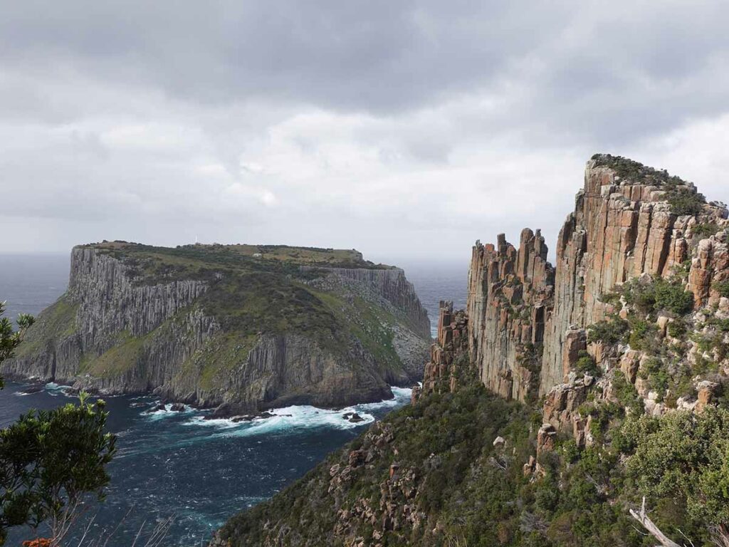
Tasman Island and the Blade as viewed from Seal Spa

On the trail humpy heading towards Retakunna Hut
Day 4 Last day! (14km)
Finally the last day of the trip is here! For once it was Gill who was up early and packed before me. After eating breakfast we left the Retakunna Hut just after 6:00am. We had originally planned on leaving at 6:30am because we needed to be in Fortescue Bay for a 2:30pm bus and wanted to get there without having to rush. But when you’re up, you’re up! Another bonus of starting early is a cool start to the morning which is a good thing as you climb Mount Fortescue, the highest peak on this trail by a long way. Having said that the design of the trail including the stepping, is done in a way that feels easier than some of the shorter peaks we’ve encountered. The vegetation on the ascent and part of the descent of the mountain is very different than other parts of this track, it’s more reminiscent of other parts of Tasmania being lush and almost tropical with all the ferns. This section of the trail from the summit downward is just spectacular. Then the vegetation changes again to be more coastal but different to what we saw earlier in the trip. The views as you walk very close to the cliff edges are spectacular with many opportunities to view the ocean as well as back towards Cape Pillar. The artwork along the trail continues for much of the morning and draws you in as you pass.
We expected to take 3.5 hours to reach the turn off to Cape Hauy but instead took just over 2.5 hours, much quicker than we expected. Just after the turnoff point is a secluded seating area to drop off the packs and just like the Overland Track, there are issues with birds wanting to access packs left unattended. As soon as we arrived a Currawong turned up eyeing off our packs. These birds are highly intelligent and are capable of taking advantage of any easy access into your pack. They can even open zips if they have enough incentive so we tend to put on the rain covers and hide the strapping and pockets underneath the packs.
The trip out and back to Cape Hauy is the real challenge not just of the day but the entire trip. When done as a day walk from Fortescue Bay there are around 4,500 steps (i.e. staircases). While you save a number of those starting from the Three Capes Track, the walk to the lookout platform took us 1 hour 40 minutes and was a heart pumper. The views on the way out and particularly at the lookout were again spectacular and well worth it. The return trip was the hard part with the final ascent back to where you leave your packs being brutal. Once we picked up our packs we then had a 1 hour walk down to Fortescue Bay and that’s what it took us.
Today we came across two echidnas – one on the steps on the way back up to the turnoff who was very happily digging after something tasty on the path totally ignoring the hikers closeted around taking photos. The other was just off the side of the boardwalk lower down. As we approached Fortsescue Bay we passed the formal trailhead so we took time for a photo opportunity and then proceeded to the bay which was full of people taking advantage of the great weather and holidays season. We headed to the ranger’s office to confirm the bus pickup point before spending some time having lunch and just resting prior to the pickup. Some of the keener hikers went for a swim and while the water looked clear and inviting, this is Tasmania and it was cold! Overall this day was one of surprises as we just didn’t think it would be so spectacular. For us it was the cliffs looking back towards Cape Pillar rather than the lookout that were the highlight. This day at 14km is the second longest day but because you drop off your pack to walk out to the lookout on Cape Hauy you are only carrying your main pack for around 11km.
Our bus back to Port Arthur is part of the trip and once we arrived we picked up our stored bag and had some afternoon tea before heading back to Hobart to end a great day and a great trip.

Step Construction. the Tasmanian stone masons do some amazing work

Walking through the temperature rainforst on day 4

Clifftop view to Cape Pillar

Sculptural seating on day 4 of the Three Capes Track

Currawong eying of out packs under the bench

Heading towards Cape Hauy

Gill at the Cape Hauy lookout

Cape Hauy

Official end of the trail on the Three Capes Track
Fortescue Bay, end of trail and pick up point for the bus to head back to Port Arthur

Bus back to Port Arthur.This trip is included in the track pricing
Flora, fauna and the broader environment
- I have done other trails that have more wildlife on them but this trip didn’t disappoint. I have never seen so many echidnas on a single hike before. The Bennett’s wallabies that lived underneath the decking of the bunk rooms at Retakunna Hut were a joy to watch as the mother would shoo her joey back under cover and then chastise the male for not keeping watch. The joey who made a sound I didn’t think was possible was just too cute for its own good. And while we saw frogs, small lizards and a fat blue tongue lizard at Cape Pillar we didn’t see was any tiger snakes although others did; one of the advantages/disadvantages of starting early in the day while it’s too cold for the snakes to be out and about
- Even though it was December we were surprised by the number of flowering pants on the trail and as plant enthusiasts we weren’t disappoint
- Perhaps the biggest surprise for us was the coastal environment that while very similar to NSW was different enough to have its own unique character

Bennetts Wallaby Joey head towards mum who is just out of the picture
Final thoughts
We originally planned to do this walk because we thought this would be a good one to review for hikers looking for a shorter trip and in all honesty while we thought we would enjoy it, we didn’t think we would like it so much. Up until this trip the only trail that I had wanted to do a second time was the Larapinta Trail in the Northern Territory. The Three Capes Track has now been added to that list and it’s one that I will do again at some stage, it’s that good. This trip isn’t a full-on camping experience because you are staying in huts and using a decent kitchen rather than a camp stove. I formed the opinion very early on that this trip is an ‘experience’ rather than just a hike and the AUD $495 track fee is well justified with the experience that it delivers.
The climate, the views, the never ending echidnas that just didn’t care about hikers, and the track facilities all help create a wonderful trip that we will not forget. This is definitely one to add to the bucket list!
Trail video
This 15 minute slide show consists of photographs and video images that will take you on a visual 4 days journey on this track
In Style
The Tasmanian Walking Company offers a luxury version of this walk if you feel like doing this walk in style and with a guide. Find out more here
Getting There

If you are a local, drive your car to Port Arthur and park in the dedicated long stay car park. If you have travelled from interstate get a bus from Hobart to Port Arthur. Hobart to Port Arthur is approximately 95 km and a 1.5-2 hour drive
Things to Know
- Phone: The signal to make phone calls and send text messages is reasonable on this track with Telstra however internet signal is limited
- Water: Water is available at each of the huts but limited on trail
- Toilets: The only toilets are at the huts but you should bring a trowel for in-between just in case
- Trail: This trail consists of formed track and boardwalks
- Steps where present are well constructed
- Dogs: Dogs are NOT allowed
- Gear
- Pack
- The Tasmanian Park Service recommends a 50 litre pack for this trip however on our trip most hikers were carrying a 65 litre pack
- PLEASE NOTE: I fit all my gear into a 33 litre pack as I know exactly what I need and want on a multi-day hike which is an acquired skill developed over a number of years (see our gear lists for this trip below). If you only have one pack don’t be tempted to fill it up just because you have space
- Spend some time putting consideration into what you are carrying and don’t be tempted to fill your pack if its on the large side. Carry luxury items by all means but do so because you are going to use them/want them
- Bring a small fold down lightweight pack for the trip out to Cape Pillar e.g.
- The Tasmanian Park Service recommends a 50 litre pack for this trip however on our trip most hikers were carrying a 65 litre pack
- Pack
- Boat ride to the Trail head
- If you want to swim at Denmans Cove and aren’t fussed about visiting Port Arthur then catch the early boat at 11:30am
- If you want to spend time looking around Port Arthur then catch the later boat at 2:00pm
- Bus trip from Fortescue Bay back to Port Arthur
- If you walk at an average pace and don’t want a sleep in then catch the early bus back to Port Arthur at 2:30pm
- If you are a slow walker or want a sleep in then catch the later bus at 4:00pm
- Other:
- This walk is done in one direction starting at Denmans Cove and finishing at Fortescue Bay
- There are USB ports in the kitchens at each cabin for charging electronics
- You can store your ‘town clothes’ in a bag at the rangers office at Port Arthur if need be
- The guide book for this hike is provided on check in at Port Arthur. If I could change one thing about this hike it would be to get the guide book prior to the hike
- Bring wet weather gear; this is Tasmania, of course you will get some rain as well as wind
- As part of the track fees you get access to the Port Arthur Historic site for 2 years
- There are a few foot cleaning stations along this track to help stop the spread root rot. Take the few minutes required to help preserve this trail

Three Capes pack for Tim

- Osprey Ultralight Stuff Pack We used this ultralight day pack for when we didn’t have to carry the full packs
Suggested Resources
- Far Out App (previously Guthook)
- The navigation on this track is about as easy as it gets. While I had the Far Out app on my phone I never used it to navigate with
Gear Lists
Everyone has preferences in relation to gear that they carry on a hike. The following are the lists of gear that Tim and Gill took on this trip
Disclaimer
This walk was undertaken by the team from Australian Hiker
Last updated
6 April 2025