Kangaroo Island Wilderness Trail (65-75km)
Flinders Chase National Park
Starting Location
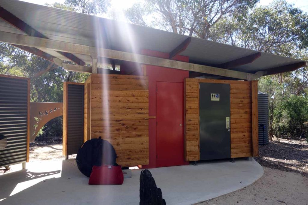
Flinders Chase National Park Visitors Centre

The trailhead at Flinders Chase National Park Visitors Centre. The signage for the Kangaroo Island Wilderness Trail is the dark green KWIT
Finish Location
Kelly Hill Caves

Tim and Gill at the finishing Trail head at Kelly Hill Caves
Best Time to Travel
March-November. This trail can be walked the whole year and there is something special in each month. Seal breeding, wildlife, wildflowers, whales!
Lessons Learnt
- There are no really steep sections on the trail so walking poles are just for stability, not hill climbing or descending.
- If you want to sleep on the tent platforms at the Cup Gum campsite on night one take some extra sections of line as well as a few sand pegs to get creative.
- If you are hiking in mid summer arrive the day before so you can start early in the morning to avoid the intense afternoon heat.
- If there is a total fire ban when you are hiking then you can’t use any type of fuel stove so come prepared for a cold meal if you need to.
- The beach walk is brutal, the whole beach is really soft and we found the best walking to be following in another persons footsteps
Things the Guide Books don't tell you about the Kangaroo Island Wilderness Trail
- The campgrounds are exceptionally well designed and the facilities are well spread out. As far as constructed trails go this is luxurious
- While I would suggest visiting Weirs Cove, skip Admirals Arch (and the busloads of tourists) and enjoy the seals from further away along the rest of the trail if you want to maintain the ‘wilderness experience’
- If you do plan on using the tent platforms at the night 1 Cup Gum Campsite take a few extra sections of line and a mixture of tent pegs including a few sand pegs to assist with the tent set up process. I use a tent which has a two sided entry and found that a few sand pegs were ideal to secure the tent in the right position by easily wedging the sand peg between the boards of the tent platform
- Phone coverage is almost non-existent which is expected (and desirable) considering the remoteness. If you absolutely must use your phone then your best option of getting a signal (without a satellite phone) is with the Telstra network.
- You don’t have to use heavy duty hiking boots to do this trail. However whatever type of footwear you use, it should be able to cope with the large sections of rocky paths so ensure that your footwear selection will cope with this
- You don’t need a compass to walk the Track. HOWEVER you do need the tools and ability to be able to navigate if you get lost.
- Come prepared to carry three litres of water if you are hiking in mid summer

Tent on one of the timber platforms at the Cup Gum camp site. Notice the sand peg wedged in a gap in the platform on the bottom-centre of the image

Sand pegs are very versatile and will slot easily into most timber tent platforms
Permit System
- A permit system is in operation year round to help pay for trail maintenance. This camp site facilities on this trail are some of the best, if not the best, in Australia and the trail permit fee is very cheap in comparison to some of the well known Tasmanian trails like the Overland Track or the Three Capes Walk. There is a maximum limit of 48 (including guides) allowed to depart each day which consist of:
- 12 independent walkers
- 36 Commercial tour operator walkers
- As at January 2025 the permit fees are:
- $199 for adults
- $120 for children between 4-15 years of age
- $159 for concession card holders
- If you want bus transfer back to the Flinders Chase Visitor contact the transfer company for details and costing
- There is no additional park entry fee required unless you plan on visiting the park before or after your trip
- Walking is one-way only
- This is a five day, four night walk, and you are only allowed to stay at each camp ground for one night each. If you walk in the low season in mid summer you may be able to skip a campground but you would need to check with the Parks service first to ensure that there is space available at the following campsites
- Book early if you want to travel at a particular time of the year as the available start dates book up quickly particularly in the autumn and spring

Kangaroo Island Wilderness Trail permit on my pack

Driving across the Hay Plain on Christmas Day. Driving the Hay Plains is something that everyone should do at least once
Kangaroo Island Wilderness Trail - Review
Planning what planning?
The best way to describe the Kangaroo Island Wilderness Trail (KIWT) is as a ‘choose your own adventure’ trail with the ability to undertake this walk in a variety of ways. What this means is that no matter what your experience level there is an option for you, making this the best Australian trail for those wishing to graduate to multi-day hiking. These options include:
- A fully self supported walk;
- Partly supported with you main pack being delivered to the camp site each day with you carrying just a day pack;
- Partially supported with you being picked up at the campground at the end of each day and taken back to comfy accomodation then being returned to the trail the next morning. In this option you again just carry a day pack; and
- Fully guided.
This trail presented a couple of firsts for Gill and I. Firstly those of you that have followed us for a while you will know that I am an obsessive planner and will plan a hike to death, months, if not years out; but not for this trail. I’ll own up here and clearly state for the record that we (I) did very little trip planning. Case in point I stupidly tried to do this trail in Easter 2017 and thought how busy can this be? Surely I can book on a month out from my proposed trip start? I quickly learnt that this was not the case so quickly opted for my next available time slot which was the week between Christmas and New Year which is probably the only time that you will be likely to book so close to the trip start but even that presents its own problems. The biggest issue with this trip, particularly for those that don’t live in Adelaide is actually getting to Kangaroo Island itself. We wanted to have a car on Kangaroo Island and didn’t want to pay for airfares at Christmas time so opted for a 12 hour drive on Christmas Day (and on the way back) followed by a ferry ride the following day which was the day we started the walk. I did book the ferry trip eight months out and while you may be able to get on the trail in mid summer at short notice you may struggle to get a ferry ticket, particularly if you have a vehicle. Having said that if you are a experienced hiker and are used to planning multi-day hikes this trip will present minimal complexity issues apart from the transfers.
The next first is that our hiking usually consists of Gill and I hiking as a couple or me solo hiking. We haven’t done group hiking for a number of years but in this case we not only hiked with a friend, but one who had never walked more than 10km in a single day and over multiple days. What this meant is that we did travel a bit slower than usual but given that I hadn’t fully recovered from a two week illness and that there was so much to see this wasn’t an issue.
A bit about the trail
This is one of Australia’s newest long distance trail having only been officially opened in late 2016 at a cost of $5.5million. The trail joined a couple of existing smaller trails and provided high quality infrastructure. What was immediately obvious to to me on this trip was that the trail had been designed by people who have actually hiked. The campgrounds are set out in a manner that provides ample space between the tent pads which helps to minimise the noise from all but the loudest snorers. The toilet block and camp kitchen are well spaced out and in most cases about 50 metres+ from the tent pads meaning that if you want to stay up late at night talking you won’t impact other hikers who have gone to bed early. The trail has also been deigned to be sustainable and by this I mean that there are no excessively steep ascents or descents apart from a couple of shortish sand dune accents and as such erosion is unlikely to be an issue. While I carry hiking poles, mainly for downhill sections, I didn’t use them at any stage.
Getting to Kangaroo Island and the trail head
Our journey started on Christmas day with a 12 hours drive to Adelaide from Canberra. Hardly a car on the road and very easy driving across some amazing landscapes. If you have never driven across the Hay Plain you don’t know what you are missing out on. If you don’t feel like the long drive then opt for a plane flight into Adelaide itself which can be followed up by a plane trip to King Island if you don’t need a vehicle
The day after Christmas day we were on the road again but this time with a relatively short 90 minute car ride from suburban Adelaide to Cape Jervis (allow two hours if you are travelling from the city centre). The drive itself was pretty easy and we turned up with plenty of time to spare and about 30 minutes prior to the office opening for the 9:00am ferry departure. Boarding the ferry with a vehicle was interesting process and an opportunity to see how people cope with some precision parking skills to manoeuvre their car into some very small spaces. The ferry trip itself was uneventful with the sea condition on the day being excellent with the trip to the island only taking just on an hour.
One of the things that surprised me about Kangaroo Island is it size. The trip from the Ferry terminal at Penneshaw to the Trail head at Flinders Chase Visitor centre is around 130km. What this meant was a further two hour drive which you will either need to do in your own vehicle or by the commercial transport services.
Please Note that this trail reopened to independent walkers on 16 December 2023 after being impacted by fires so the landscape and facilities will look different to what is shown below. Listen to podcast episode 306 to hear what the trail is like as at the end of 2024. This trail is back!

Flinders Chase Visitor Centre, your starting point for the trail

The Hike
Day 1 (12.1km)
We arrived at the Flinders Chase visitors centre around 12:20pm and checked in with the rangers who issues us with our permit tags. Rather than eating lunch we decided to start our hike and find a spot to eat on the trail. One comment that I would make here is that temperature was in the mid 30’s (Celsius) and if I did this walk at this time of the year again I would arrive the day before to get an early start. Hiking in mid summer really means that you want to start early to avoid the heat.
The trail head for this hike is a bit invisible and once we worked out that we needed to head to the back of the visitor centre to a central point where a number of small walks started we were fine. One thing that we did find confusing was that while we new we were headed to the Cup Gum Camp Ground but it took us a little while to realise that the signage we needed was the KIWT sign that directed us to Rocky River which was one of the original trails that went into forming this larger multiway hike. We found this as a pattern on the rest of the trip as well with the next camp site not featuring on the trail signage. The 12km to the Cup Gum camp site took us just on four hours but this also included a descent lunch break. I found this an interesting trip with all of the waterways being relatively dry but in talking to the Trail manager it does flood occasionally and would be a very different walk in wet conditions.
We came across two Goannas on this first section of the trail. The first and largest one of the trip saw us and speed of very quickly. The smaller one in the image below pretended to be a statute in an attempt to hide but didn’t do a very good job. The Goannas ‘farm’ the trail looking for food and on our trip there were a number of holes along the trail edge and sometimes in the middle of the rail so pay attention to your footing. We arrived at Cup Gum at around 5pm and on doing a look around decided to camp on one of the platforms on offer. Great platforms, very well set up but you will need either some sand pegs or additional cord to get the best out of the test tie down particularly if you aren’t using a freestanding tent. By dinner time we were surprised to find that there was only a total of seven hikers on the trail for that day but this is one of the advantages of hiking during the summer months.
One of the disadvantages of hiking in mid summer was that one of the rangers placed a total fire ban sign in the kitchen area advising that the following day a total fire ban was in place which meant that we couldn’t use any type of gas stove and had a cold dinner to look forward to the next night.
Toilet facilities typical of the campsites

Camp Kitchen example

Please don’t encourage the wildlife, its bad for them

Kangaroo Island Caravan Park Gear Trailer. If your gear is being transported from camp to camp it will be kept in a secure, locked, and weatherproof trailer
Day 2 (23.2km)
After day one’s oppressive heat we opted for an early start which was a good move so we were up early and on the trail walking by 6:15am. Being late December it was light and all was going well until we reached the ocean cliff when my camera decided to die. Luckily I was carrying my iPhone but it wasn’t what I had planned. We ate breakfast looking out on the ocean and for me its hard to get better than that. Our trip along this part of the trail was mainly spent walking along the cliff edge but was interspersed with a section of a couple of kilometres on the beach. The beach walk can be bypassed if the tides are high but it was an interesting walk to do all be it a hard one. I’m used to walking on beaches and usually you will find that there is a section of compacted sand that is easy to walk on but in this case this didn’t exist with the sand being all soft. If you have the choice walk in someone else’s footprints to make it a bit easier.
One thing the ranger warned us on at the start of the walk was to avoid the nests of the Hooded Plovers who nest on the beach and will pretend to be injured to draw a potential threat away from their nest if you get too close. This behaviour surprised me as I’m used to the species of Plovers that we get in southern NSW that will go into ‘Kill mode’ during nesting season if to dare to get within a 100meters of their nest, or look at them the wrong way.
After some pretty amazing views along the coastline we ended up reaching Hakea camp ground which was our night two camp at around 11:30am which meant a total time of 5.5 hours. The guidebook suggests that the optional extension to this trip to Admiral Arch, the Cape du Couedic Lighthouse and Admirals Arch be done on day three but given that is also the day that you will visiting Remarkable Rocks we decided to do the spur trip after lunch on day two which made for an all up distance on day two of 23.2km. This ended up being our longest day of the trip. I have spent a lot of time diving with, and being around seals in the past, so would be more than happy to suggest that you skip Admirals Arch and the Lighthouse as it’s a tourist trap with hundred of people in buses and cars distracting from the ‘wilderness experience’. You will see seals along the rest of the trail and while you won’t get as close you still get the experience.
Hakea Camp ground is another excellent facility but no timber tent platforms at this site or the others to follow. Having said that compact sandy tent pad are well done and rock free.


This was the first view of the ocean on this trail. Although this mage doesn’t show it there was a strong rip on the right hand side of this little bay

A sign of the times. Even though drones are prohibited we still had one buzzing around Remarkable Rocks

Admirals Arch. A great place to see seals, and tourists!
Day 3 (14.2km)
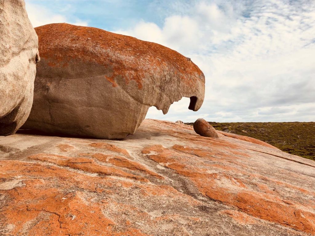
Day three was 14.2km including the side trip to Remarkable Rocks and for the three of us in our group this optional visit was one of the highlights of the trip. We spent about 80 minutes there just wandering around and taking in the views and could have very easily spent half a day there. This should formally be considered part of your trip so factor it in to your timing. We arrived at Banksia Campground around 12:40pm so all up this day was about five hours long. We were originally going to stop in at Sanderson’s Bay but had been advised that the beach we would go to the next day at Hansons Bay was a better option.

Remarkable Rocks

Ocean View

More Ocean views

Tent on sandy pad at banksia camp ground

Look out for the Bees in the Banksia Camp Ground Kitchen area. They hang around the sinks looking for water
Day 4 (15km)
This was our walk to the last of our campsites at Tea Tree (Grassdale) and again this site had something different to offer. We had been looking forward to the river crossing and also our short side trip to the beach. We got lucky on this trip as the ocean was flatfish, you could swim if you really wanted to and on arrival we were treated to a pod of dolphins and a couple of seals chasing fish into the bay. After having an early lunch on the beach we head off leaving Kellie, our non hiking friend, to do a solo walk into the camp ground for the night. The trail was easy enough to follow although one of the other hikers who was ahead of us missed the turnoff and did almost half of the final days walk before realising that she had gone to far. Kellie turned up as expected but decided from the experience that she was unlikely to ever be a solo hiker instead preferring the company on the walk.
Tea Tree Camp Ground at first glance was a bit disappointing; The physical structures are the same as the other sites but it just has a funny feel about which we all agreed on but it’s hard to explain. If I had to define this I would put it down to be adjacent to old rural area. After we had settled in we walked the approximately 1km down to the historic Edwards Cottage just for something to do before heading back for an early dinner and an early night.

Hanson Bay Beach appoach

Hanson Bay Beach

Lagoon crossing day 4. From here its a very short walk up a small hill and you can either turn right the Hansons Bay Beach or left to the camp ground
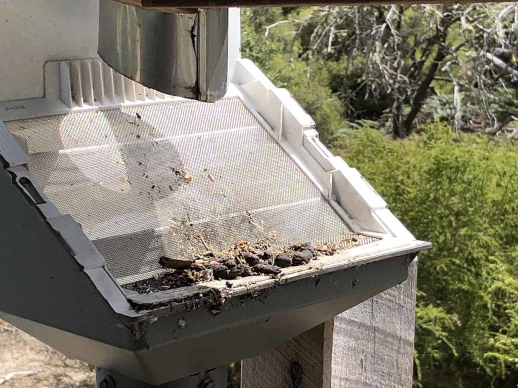
While these filters will remove the solids (like this possum poo) from the water it doesn’t stop bugs and bacteria getting into the water. Always filter the water just in case

Campground entry signage

Campfire at Tea Tree camp ground. This fire can only be used in the colder months
Day 5 (7.6km)
By the morning on the last day Tea Tree camp site had redeemed itself as it turns out that this is where much of the wildlife on the trail congregates and it just feels better in the morning. We had Kangaroos, Wallabies, birds of all types and last but not least Koalas. Kellie had one turn up outside her tent overnight which had a look inside the tent before racing up the adjacent tree. On the way out of the camp the three of us saw one that was on the ground moving from one stand of trees to another that proceeded to come and sit in front of us on the trail not long after we left camp. I had the distinct impression it was sizing me up and gave a very strong impression that it was about to climb up me but instead raced off to a nearby tree.
We finally reached the end of the trail at the Kelly Hill Caves trail head just over two hours after we started which gave us ample time to do a visit to the caves which is included as part of the track fee. Again well worth a visit and it kills some time before a transport back to the visitor centre.
In total we did the just on 75 km in five days which included the trail itself and the side trips. Nothing strenuous and while it would have been possible to easily do this trail in three or four days the KIWT is just one of those trails that invites a slower pace.

Sunrise at Tea Tree Camp Ground on the last day
Tim and Gill at the finishing Trail Head

Kelly Hills Cave

Return bus back to the Kelly Hill Caves final trail head to pick up our car
Flora and Fauna
In talking to the rangers they indicated that snakes were very active at the time we walked but we didn’t see a single snake on the entire trip. In addition while there are ticks on this trail they don’t target humans but focus on the wildlife which makes me very happy. When we interviewed the trail manager on this hike she indicated that each month has something to offer on this trail and everyones experience is going to be different depending on who they travel.

Callistemon in flower

Banksia in Flower

Succulent on the trail

Goanna on the trail
Last Words
If you are an experienced hiker you may not consider this trail to be overly taxing but you will enjoy it as it has so much to offer, and so much to see. If you are new to multi-day hiking then this is the trail for you as it it has much to offer without the complexities of more challenging trails like the Overland Track or the much longer Larapinta Trail. From my perspective I would happily do this trail again but choose a different time of the year to get a different experience.
On our last day we were hoping to see Koalas and on the way out of our last camp ground, Tea Tree, the trail obliged
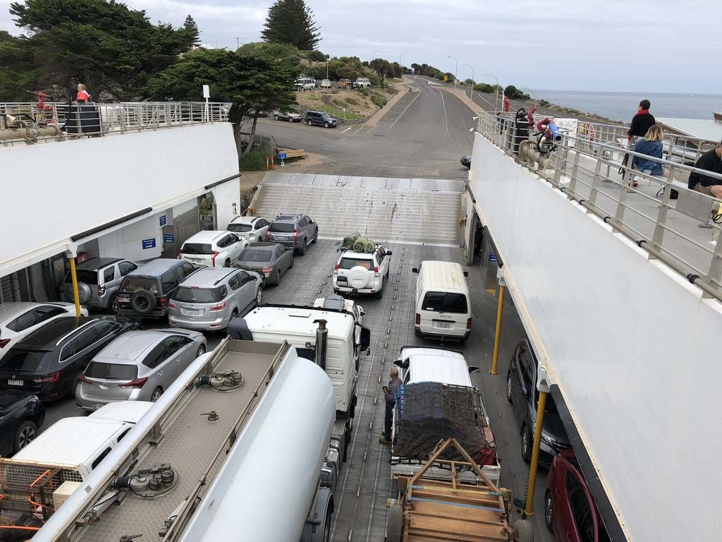
Vehicles parked on the ferry for the return trip
Resources
Transport – Kangaroo Island Transfers
- Transfers to and from the Ferry in Penneshaw or the Airport in Kingscote to the trail head
- Pack transfer from campsite to campsite (just carry a day pack)
- When you go to this page go to the option and click on the link to get a price
- a self-guided walker using the campgrounds provided and a commercial operator will transport your personal equipment from one campground to the next.
- When you go to this page go to the option and click on the link to get a price
Kangaroo Island Wilderness Trail website from National Parks SA
Kangaroo Island Wilderness Trail Booking System
Sealink Ferry from Cape Jervis to Penneshaw
If you would like to listen to the associated podcasts on this trip they can be found at the following links:
049-Kangaroo Island Wilderness Trail here we come! Our expectations
051-Kangaroo Island Wilderness Trail-A day on the trail
052-Kangaroo Island Wilderness Trail; Interviews from the trail
053-Kangaroo Island Wilderness Trail; Reality vs expectations
After the fires:
306. Kangaroo Island Wilderness Trail revisited (To launch late on 7 January 2025)
Getting there

Kangaroo Island is located approximately 15km from the South Australian mainland. The island can be accessed by either plane or ferry.
- The flight from Adelaide is to the airport at Kingscote.
- The ferry is from Cape Jervis to Penneshaw. Cape Jervis is around a two hour drive from the centre of Adelaide and once you board the ferry the trip is a further one hour. The advantage in taking the ferry is that if you can bring your own vehicle to travel around the island.
Last updated
7 January 2025