The Link to Shepherds Lookout Walking Track ACT (7.3km)
Canberra City
Nearest Town
Strathnairn, ACT
Best Time of the Year to Travel
Year round
Starting Location
The Link, Arts and Community Centre, Strathnairn, ACT

Finish Location
The Link car park, Strathnairn
The Link to Shepherds Lookout Walking Track Review
At the time of this review in early 2022 this was Canberra’s newest designated walk providing a reareational activity for the newly formed surrounding suburbs. I must admit after looking at satellite images of this area prior to the walk, I didn’t have high expectations but soon realised that the images were out of date. The result is that I enjoyed this walk much more than I expected.
This walk starts at the Link which is a local community and arts centre located in the suburb of Strathnairn on the edge of adjacent rural and bush land. After parking in the Link car park we headed through a makeshift gate and down the old management road to the start of the walk. The map information and temporary signage suggests that the road will eventuality be extended.
For us this walk was one of quarters. The first section of the walk from the Link into the reserve is very much a rural landscape. The trailhead is about 300-400 metres from the Link at which point you turn left into the reserve. You enter through a timber opening in the fence which is really only accessible to walkers. Dogs aren’t allowed onto the reserve.
There are two things that you will notice once you enter the reserve. The first is a small ground-level snake warning sign. Given the grassland and the fact that this area has been relatively unused by walkers, you should expect to see snakes. We didn’t see any snakes on the day but it had been raining and was relevantly cool so that wasn’t surprising although I have never seen so many curved sticks in my life on the ground! The second thing that you will notice is the occasional metal sculptural ‘plants’ along the first section of trail which, given this trail came about as a way of highlighting the view made famous by artist Elioth Gruner in a 1927 painting, is understandable. The sculptures are are very impressive and its worth spending some time to take in their detail.
From urban landscape you enter into bushland for the middle section of the trail. It’s a very different bushland than that which surrounds many other remote and not so remote areas of bush in the Canberra region. This middle half of the trail is for us the most notable and enjoyable section of this walk. During this section you will make your way through two stiles, one of which you have to go up and over. At the time of this review you could go around the second but you should expect the fencing to be fixed at some point.
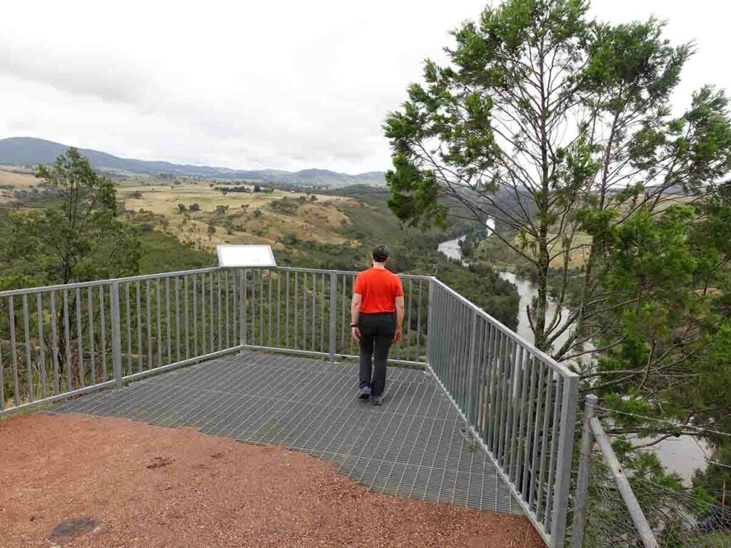
As you make your way through this section you will come across a split in the trail – we stayed to the left which took us up and over the hill. It was around this stage we came across some wallabies just off the trail and one on the trail that hopped away when it saw us. As we came towards the end of this middle section there was a natural lookout just off trail with great views down into the valley. A short way along there is a constructed metallic lookout that showcases the view made famous by artist Elioth Gruner. This lookout is a great place to stop for a break which we did on the way back – it has a timber bench seat as well as providing the option to sit on the edge of the platform.
From here the landscape opens up and the trees thin out on the approach to Shepherds Lookout. This trail connects in with the standalone Shepherds Lookout Walk so shares part of this trail providing views down to the river and the valley below. Once you have taken in the views you can return the way you came or do the short loop that also takes you back to the the same point. The return trip back provides views from a different direction and you can also choose the alternate route that you didn’t take on the way out. In our case we again kept left and ended up at another lookout view that also had a couple of rock seating areas.
We started this walk late for us and on the way back came across a number of other walkers doing this trail. Given its the main walk in the area, the number of people doing this walk didn’t surprise us. All up this walk measured 7.3 km on sections of management road or construct trail. You can tell that this walk is still relatively new because there is limited (no) signage but the trail is very obvious so you don’t really need navigation skills but rather just need to pay attention.
We enjoyed this walk so much more than we thought we would and its well worth doing as a one of or if you are a local, as a regular walking track. One final thing to note is that the estimated time for this walk is 2 hours but for the average walker I would suggest allowing up to 2.5 hours so you aren’t pressed for time.

Follow the signage. At the moment the signage is only temporary and it appears that the road will be extended a bit further at some stage

Temporary gate just down the dirt road

Bicentennial National Trail signage

Dogs are allowed on a leash up until the point where the trail formally starts

Rural infrastructure

Trail start signage about 3oo metres from the car park

Through the fence to start the trail

Snake sign

Artwork on the trail

Panoramic view 1

Dam on trail

Seat on the trail

Over the stile

Hello Wallaby

Trail options. The trail spilts at this point and we went left. We came back via the other branch

Tree bark

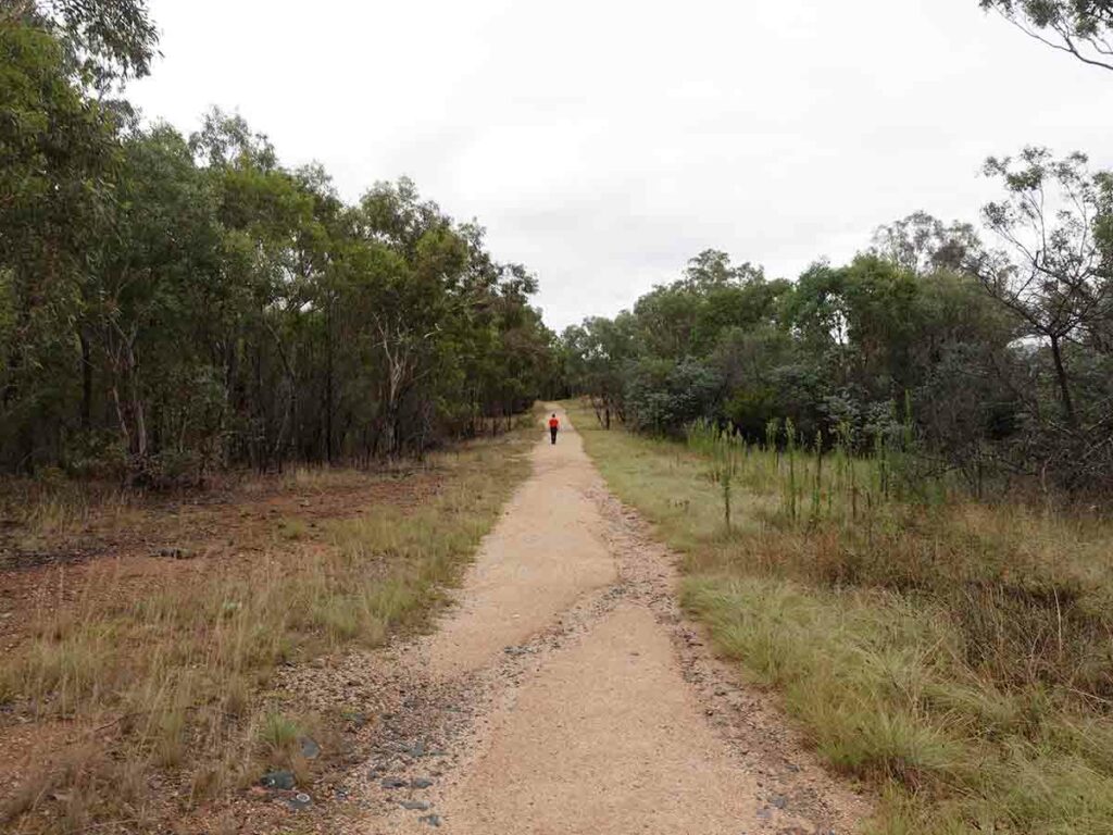
Trail example

Off trail lookout

Panoramic view from the lookout

Artist view made famous by Elioth Gruner in a 1927 painting. This lookout was created to allow walkers to better see this view

Taking in the view

Trail example

Heading towards Shepherds Lookout

Loop option to Shepherds Lookout
Almost at Shepherds lookout
Shepherds Lookout

View at Shepherds Lookout

Loop back from Shepherds Lookout

Uriarra Loop turn – head left not right

Trail options join up on the way back

Heading home over the bridge

Through the fence

Almost home

Back to the trailhead
Trail Videos
This short video contains photos and videos to show you the walk from start to finish
Getting There

Google maps -The Link to Shepherds Lookout from the Canberra GPO, ACT. The trip is around 20 minutes drive to the trailhead

The turn to the Link
The turn to the Link car park
Things to Know
- Phone: There is excellent phone coverage on this trail (Telstra)
- Water: You need to bring your own water
- Toilets: There are toilets located at the the Link Community Centre however you need to check the opening hours
- Trail: This trail consists of formed track
- Dogs: No dogs allowed on the main trail
- Camping: No camping allowed
- Other:
- This walk is an out and walk back experience
- Keep an eye out for snakes during the hotter weather
- Keep an eye on young kids at the natural lookout areas as there are steep drop-offs
- This is a popular walk so start early if you want a bit of privacy
Disclaimer
This walk was undertaken by the team from Australian Hiker