Snowies Alpine Walk NSW (56km)
Kosciuszko National Park
Nearest Town
Jindabyne, NSW
Starting Location
Guthega, NSW

Car park at Guthega

Guthega trailhead. You can drop off hikers here but you can’t park
Finish Location
Bullocks Flat, NSW

Trailhead at Bullocks Flat
Late November to mid April
- This season can be extended if the snow holds off
Which direction?
- Starting at Guthega
- If you are only travelling from one village to another, then we recommend you start in Guthega and finish at Bullocks Flat because the views are better when you walk in this direction
- If doing this walk one way, you will need to organise a lift back to your car
- Starting at Bullocks Flats
- If you are wanting to acclimatise to the elevation, then you can start at Bullocks Flat and finish in Guthega
- Be warned, this direction is all uphill!
Choose your own adventure
The Snowies Alpine Walk consists of four sections and if you are following the National Parks and Wildlife Service guidance the sections are:
- Guthega to Charlotte Pass – 9km
- Main Range Walk (i.e. Charlotte Pass to Mt Kosciuszko and return to Charlotte Pass) – 22km
- Charlotte Pass to Perisher Village – 12.7km
- Perisher Valley to Bullocks Flat – 12km
The above has been designed for stays in local lodges and cottages in the destination villages and for you to arrange commercial transport between your start and finish points.
The beauty of this walk is that it can be done in a range of ways and we talked to people who were doing the walk in sections on different visits and others who were part of guided groups. There was even one group doing it in one day but we wouldn’t recommend this for a range of reasons including because they started at Guthega at 4am!
We undertook the walk over three days:
- Guthhega to Charlotte Pass then on the Main Range Walk to Mount Kosciuszko and camping past Seamans Hut – 25km
- Seamans Hut to Charlotte Pass, Perisher Village and then commencing the Bullocks Flat walk to camp away from the Perisher catchment area – 20.7km
- Continuing along the Perisher ridge to finish at Bullocks Flat – 10.3km
Be aware that doing it this way, days 1 and 2 are big days, mostly uphill and at elevation.
The Snowies Apline Walk is on a very obvious trail with trail arrows and kilometre markers so as long as you’re hiking outside of the snow season, then it is almost impossible to get lost.
Whatever your plan, make sure it suits your hiking style and interests and make sure you HYOH!
Camping restrictions
While you can ‘wild camp’ in Kosiuszko National Park, there are some restrictions which you can find here.
NSW Parks APP
The NSW Parks App which can be downloaded through Apple or Google is a handy app for this and other major trails in NSW
Shuttle Services
If you aren’t able to arrange a car shuttle within your group, then look at a commercial shuttle services here.
Podcast
Our on trail podcast for this 3 day adventure will go live early Wednesday morning 5 February 2025 AEDT
Day 1: Guthega to Charlotte Pass and Main Range (25km)
Guthega to Charlotte Pass
The Guthega to Charlotte Pass section was the first ‘offical’ section of the Snowies Alpine Walk which had been upgraded with new boardwalks and bridges.
We first did the section in November 2022 when it was around 95% complete and all that was missing was formal trailhead signage at Guthega and a finished drop off point. With the completion of the Snowies Alpine Walk there is now a very prominent trailhead – it definitely feels like the start of something big! There is now a good drop off area at the trailhead but you need to park around 350m away at the Guthega Village car park if you are leaving your car.
Gill started to walk at just on 8:00 am and like many other walks in this part of the park, getting a slightly earlier start means you have the trail to yourself at least for part of the day. The weather was great and bush was vibrant and of course, the views towards the mountains, fantastic.
Gill had the trail to herself and it wasn’t until she was closer to Charlotte Pass that she met a couple of day hikers coming the other direction. The trail width is comfortable enough for one person but if you do come across other trail users, its easy to allow them to pass. Traditionally you give way to hikers coming uphill but sometimes its hard to tell what that is and other times it just makes sense to give way to a larger group.
We have done many of the walks in this area of the Kosciuszko National Park but this section continues to be a favourite. The trail follows the valley along the Snowy River and parallels the road that runs through the centre of the Park and finishing at Charlotte Pass. The Snowy River is your constant companion on this section and even on the rare occasion you move away from it, you can almost always glimpse the river if not hear it. Speaking of the river, the clarity is just amazing and even though the images below were taken well over 30-60 metres away, you can still see into the water.
The trail tread consists of natural trail, natural trail with flat rocks, metal mesh and various sets of stairs made of the same materials used on the trail. There are also two bridges on this trail; a shortish one close to the Guthega trailhead and a much larger longer suspension bridge. What this means is that at no stage do you need to get wet feet to complete this section. Some of the older trail replaced by this new trail was still obvious and in all honesty, this new trail will ensure that damage to the landscape from walkers cutting their own path will progressively disappear.
The landscape overall varies between open grassland, alpine heathland, as well as small sections of Snow Gum Forest and provides plenty of variety. There are amazing views towards Australia’s highest mountains that are just that much better when you’re walking in this direction. While your legs will feel this walk it is by no means difficult. An important thing to be aware of on all the sections of the Snowies Alpine Walk is that the UV index can be brutal in the Australian Alps even when it doesn’t feel that hot so cover up, including considering wearing fingerless lycra sun gloves.
Don’t expect to see much in the way of animal life on this section although Gill did come across the occasional wombat hole along the way. However, the birdlife and birdsong is plentiful! Gill did this walk in late January so the wildflowers were fading given the recent very hot weather and big storms but there were occasional glimpses of their former beauty.
This is a great section and a promising start to the longer Snowies Alpine Walk!
Charlotte Pass to Mount Kosciuszko
From Charlotte Pass Gill headed back down to the Snowy River along the Main Range towards Blue Lake. The views are so stunning along the Main Range that soon after completing the circuit you forget how tough that climb is! While Gill wasn’t carry a heavy overnight pack (only around 9kg) she really felt the climb!
The first part of the Main Range is on mainly paved trail and apart from the first 500 metres, which is a downhill stretch, the rest is all up hill. Just before you start the uphill stretch you will cross two river sections which rely on you nimbly stepping your way across well placed stones. There are warning signs that advise against this crossing if the stones are underwater which would be likely during full snow melt or after heavy rains. After these river crossings you have a relatively steady uphill run to reach the top of the Main Range which does take a bit of effort given its so early on in the hike.
The Main Range walk also has long sections of mesh boardwalks that keep you up out of the fragile vegetation – at times Gill was able to scoot along at a good pace to make up for that climb from the Snowy River.
By world standards Australia’s highest mountains are pretty small but with a minimum altitude over 1700 metres it does require more effort than you would normally expect if you were at lower altitudes closer to the ocean.
The Main Range trail tread has also been upgraded but the mostly stone trail is really tough underfoot. Gill was wearing her usual Altra Lone Peak 8 trail runners but for this trail probably should have opted for the Topo Athletic Terraventure 4 which have a ‘rock plate’ for added protection and toughness when on hard surfaces.
The Main Range is always a popular walk and today was no exception. Lots of people were passing Gill and she often felt the pressure of keeping up but then rationalised her thoughts given she was carrying much more than a half empty day pack! As the saying goes, slow and steady wins the race and she was able to not only catch up with a few groups but even overtook some!
The weather was lovely – around 24° Celcius and clear skies so there was plenty of opportunity to take some great vista pics. Whenever we do this section we are always amazed about how unprepared people are for the possibility of changing weather conditions. It is the ‘Snowies’ after all and it can change dramatically and quickly. Again today Gill saw many unprepared for the unexpected.
Mount Kosciuszko to Seamans Hut
Once you summit Mount Kosciuszko the next stage is downhill via the management road which branches off at Rawsons Pass and Australia’s highest toilets! Gill took the left route to towards Seamans Hut a few kilometres down the road and met Tim who had walked in 6km via the return route from Charlotte Pass.
Seamans Hut is for emergencies only and camping isn’t allowed so we headed a little further on to set up for night.
Car park at Guthega which is about 100 metres from the tailhead
Snowies Alpine Walk trailhead at Guthega which has a hiker drop off point

Snowys Alpine Walk trailhead sign at Guthega

Trail at the start

First bridge
Snowy River. The water is always so clear!

Suspension bridge on stage 1, Guthega to Charlotte Pass

So pretty. The wildflower season was all but complete – there was still the odd bit of colour about

Gorgeous Snow Gum bark

Trail example

Trail example 2

Mesh track example

Stairs on the trail

Tim meeting Gill at Charlotte Pas. Turn left up the hill to Charlotte Pass or right to head on the Main Range Walk

Reaching Charlotte Pass

Charlotte Pass toilets – only if you’re desperate!
Tim at Charlotte Pass

Warning sign at the Snowy River

Up on the Main Range

Up on the Main Range

Up on the Main Range

Heading up towards Mount Kosciuszko

Mount Kościuszko Summit
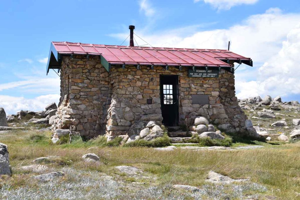
Seamans Hut; our destination for the first day
Day 2: Seamans Hut to Perisher Village (20.7km)
Seamans Hut to Charlotte Pass
We started day 2 reasonably early with a 6km walk back to Charlotte Pass along management road. This management trail is probably the least exciting section of the Snowies Alpine Walk but it does include the historic Seamans Hut as well as crossing over the Snowy River which provides an opportunity to dangle you feet in the cold water if you feel so inclined.
This stage completes the Main Range loop that returns you to the Charlotte Pass car park. The return trip from Mount Kosciuszko to Charlotte Pass while forming part of the Main Range Walk also includes the Mount Kosciuszko Summit Walk.
Charlotte Pass to Perisher Village
Once we got back to Charlotte Pass we were curious about where the Charlotte to Perisher section commenced. It turns out that the next trailhead is approximately 1.5km away. You need to walk (or be driven if you have car support) down the road or down the open area near the ski lift. If you head down the road, you need to turn right onto Charlotte Pass Way. The day before, Tim had moved our car from Guthega to the Main Range trailhead car park so he drove Gill to the Charlotte Pass trailhead and she was very thankful!
Once on the trail towards Perisher, Gill scooted passed a small group of day hikers and then along the valley keen to get out of the sun and into the treeline again.
This section of the Snowies Alpine Walk, while similar to the Guthega to Charlotte Pass leg, is also quite different. While the snow gums continue to dominate, the low vegetation starts to have more variety. You remain in the treeline for around four kilometres crossing out a couple of times to navigate a valley before heading back up into the trees.
Gill saw two small Brown Snakes in different locations early on this part of the walk. She had to jump over the first one and almost tripped over her own feet trying to avoid it as it sunned itself in the middle of the trail. The second was a little faster at getting out of her way but on both occasions she didn’t hang about to take photos.
There is a strong temptation to meander on this part of the trail given the largely undulating trail, rushing creeks and well positioned seats. However, Gill had a few kilometres still to go and knew that the approach to Perisher via Porcupine Rocks was going to be a challenge. On she went and was soon glad she did! This next stage of the journey has been extended by a few kilometres and takes you back into some high altitudes and steep climbs. The trail continues to be mostly large rocks – having done 25km the day before, Gill’s feet were really started to complain today!
Tim was tracking Gill throughout this walk via her Garmin so he knew exactly where she was at every step. Up until this point they could mostly (but not always) be in touch via text messages. However, on this part of the walk there were long periods where Gill was out of phone range. Tim had expected Gill to take a shorter route to Perisher and thought she had lost the trail! He couldn’t text her and she was so focused on moving didn’t realise he was sending messages via the Garmin. She was back in phone coverage for a moment and phoned to check in and he asked if she was lost! Here is the thing about the Snowies Apline Walk – the trail is so well formed and the trail markers with arrows and kilometres so regular, you would have to be trying really hard to get lost. No she wasn’t lost Tim; she was following the trail which was taking the scenic route towards Porcupine Rocks!
Arriving at Porcupine Rocks was both a relief and a challenge. It was the beginning of the drop into Perisher but it was also the windiest spot Gill had encountered so far. At one stage she thought she was going to be blown away and keeping her hat in place to block out the sun was almost impossible.
At this point there were lots of hikers coming the other way – mostly multiday-ers given the size of their packs. A couple of groups had around 12-14 people in each and she had to step to aside of the trail to let others through. Gill was curious as to why you’d start at Perisher and go high given she had been heading down for a while. Then she hit yet another series of climbs and realised that there was up and down irrespective of the direction you took!
Gill arrived in Perisher Village around 1:00pm having travelled over 18km since the start of day 2. Tim had driven the car from Charlotte Pass to Perisher Village and was waiting there for her. After a few hours rest and seeking refuge in the car from the persistent March Flies, they headed back to the trail and turned left onto the Bullocks Flat Walk. They went up and just out of the Perisher catchment and around 2km along the trail, found an OK spot to pitch the tent for the night.

Sunrise on the trail day 2 Snowies Apline Walk

Seamans Hut toilet

Crossing over the Snowys River near Seamans Hut

Native Bluebell

Heading towards Charlotte Pass

Trailhead at Charlotte Pass Village
On the trail to Perisher Valley

On the trail day 2

Seat on trail day 2

Trail example day 2

Paper Daisy day 2

On the trail day 2

Trail example day 2

Trail example day 2

Trail marker sign day 2

Turn off to Bullocks Flat. To get to this point you can either turn right as you come down the hill towards Perisher Village rather than doing the last 300 metres, or else go to Perisher Village trailhead and turn around and come back up the hill to this turnoff

Trail marker day 3; off to Bullocks Flat

Heading towards Bullocks Flat

Orange Breasted Wren on the trail
Day 3: Perisher to Bullocks Flat (10.3km)
We were up super early this morning – a combination of a tiny tent, and condensation inside the tent because of the still night. We decided to pack up and head our separate ways snacking on our respective breakfasts as we went. Tim headed back to Perisher to the car, and Gill started what turned out to be a very pleasant 10.3km downhill run into Bullocks Flat.
And what a downhill run this was! The trail was now dark rich soil which while packed down, was soft underfoot and a welcome relief from the stone trails of the previous two days. The mist was still hanging in the air and created an ethereal feel also welcome after two high UV sunny days.
Gill soon discovered that while not ideal, where we had pitched the tent the night before was one of the better options. Around the 9km marker there is a lookout a short distance off the track where a couple of people had pitched their tent for the night – a better spot than ours but if we hadn’t beaten them there, we would have had few other options. At around the 8km marker there are a number of super large, flattish granite rocks – a camping possibility? Maybe.
And then a little further on, two people had pitched a one person tent and a bivvie, on the very edge of the trail. Gill remembers commenting to Tim the day before that our tent was way too close to the trail but we were miles away in comparison!
By now the vegetation was changing from the dominant Snow Gums to a mix of taller Eucalyptus, Banksias, Callistemons, Lomandra and ferns to name a few. There was lots of birdsong and a couple of startled wallabies not expecting anyone out and about so early.
As Gill wound her way down she would come across a waterfall or creek and a well placed seat from which to take in the ambience of this dense vegetated surrounds. It was hard not to stop every ten steps just to take a picture of something new she had discovered.
The Park Rangers have been hard at work on this part of the trail – some of the mesh boardwalks, steps and creek crossings are nothing short of impressive. Gill found herself taking videos along them and down the steps.
She was alone on the track until about the 5km marker when a runner came past heading up the mountain and then not until around the 3km marker when overnight hikers and family day hikers were headed up the steep climb. Gill was very happy to heading down.
Perisher to Bullocks Flat was without a doubt Gill’s favourite part of the Snowies Alpine Walk and she has the many, many pics and videos to prove it!
Its not clear why but the last kilometre of the day always seems the longest and Gill’s final walk alongside the ski tube line, past the toilet and emergency evacuation point, and under the road rail line to the car park seemed to take ages.
It was only around 9:30am but it was starting to get busy with walkers, hikers and mountain bikers. Tim had driven from Perisher to Bullocks Flat (about an hourlong drive) and was waiting for Gill at the car park.
A great end to another fabulous Kosciuszko hike!

Low cloud start to day 3

Foggy start to the day

On the trail day 3 – much softer underfoot today

Stunning Eucalyptus bark day 3

On the trail day 3

Some serious stairs on this section

On the trail day 3 with the sun starting to burn

On the trail day 3

Almost to the finish of day 3
Bullocks Flat trailhead
Trail video
This short video contains photos and videos to show you an overview of the walk from start to finish
Getting There

Google Map from Jindabyne to Guthega for a trip of just on 43km
Things to know
- Phone: There is reasonably good but variable phone signal on the high points on this trail (Telstra)
- Water: Bring your own water (we had a 20 litre container in the car that we used to top up our water bladders) otherwise bring a filter and draw water from the rivers
- Toilets: There are toilets on this trail located at Charlotte Pass, Rawson Pass, Seamans Hut and Bullocks Flat
- Trail: This walk is on stone trail and steel mesh with some natural trail
- Dogs: Dogs not allowed
- Camping: Camping allowed within selected areas. See restrictions at the link below
- Other:
- Unless you are into snowshoeing or skiing, do this walk late November to mid April. Even then, check the conditions just in case
- Check the snow conditions if hiking outside of summer
- Bring a broad brimmed hat, long sleeved top and long pants as the UV index can be brutal in the Alps
Disclaimer
This walk was undertaken by the team from Australian Hiker