Garmin GPSMAP 66i Handheld Hiking GPS & Satellite Communicator
Safety
Rating
| Rating: | 8.6 / 10 |
| Value for Money | 1.7 / 2 |
| Ease of Use | 1.5 / 2 |
| Battery Life | 1.9 / 2 |
| Weight | 1.7 / 2 |
| Versatility | 1.8 / 2 |
For the past four years I have been using, and have been very happy with, my Garmin InReach Explorer+. While my current unit is still working really well, and will continue to be used, I decided an additional unit was required for a number of reasons.
Typically when Gill and I review a walk we will do it together from start to finish. I will log the walk with a standalone GPS to collect all the relevant information rather than rely on third party information. In addition, if the walk is out of phone range or I am doing a solo walk, I will also take my Garmin InReach Explorer+ because as a satellite communicator I’ll always have access to emergency services. Occasionally when we do longer distances on a single day Gill drop’s me at one end of the walk and I’ll head off. Gill then drives to the other end and starts her walk so we meet somewhere in the middle where she turns around to finish the walk back at the car. While I’ve always had an emergency beacon that allows communication via satellite Gill didn’t have the same functionality including the ability to communicate with me on some hikes so I decided it was time for a second unit.
After much research I chose the Garmin GPSMAP 66i Handheld Hiking GPS & Satellite Communicator and in this review I discuss why.
The Garmin GPSMAP 66i Handheld Hiking GPS & Satellite Communicator is almost I’m possible to find byut you can find the newer model, the Garmin GPSMAP 67I GPS Handheld with InReach Satellite at Wild Earth
GPSMAP 66i Handheld Hiking GPS & Satellite Communicator Review
I’ll own up here and say I’m definitely a gear freak and love buying ‘toys’ for my activity of choice and hiking is no different. As mentioned above I still own a perfectly serviceable Garmin InReach Explorer+ which I purchased in 2018 prior to starting my trip on the Bibbulmun Track. At that stage the unit was one was one of the first units released by Garmin following their 2016 acquisition of DeLorme. At that time, the Garmin InReach Explorer+ was the top of the line unit in this range. Fast forward to 2022 and the inReach family has grown with each model having specific features and pricing to fit a particular niche.
When choosing a unit from this extensive range I’ll be honest I always look for lots of ‘bells and whistles’ but for me the key features I was after were:
- An extensive battery life
- A PLB function
- A full function colour GPS
All other features were a bonus.
Negatives
I’ll start with the negative on this device and then progress into the plusses. Firstly, Garmin now produces such a huge range in the inReach family that it can be hard to work out what’s what. As an example, the ’66’ range comes in the following models, the S, SR, ST and I versions that range in price from AUD $599-799 RRP. The S and ST models take AA batteries while the SR and the I models come with integrated Lithium batteries. If you are doing long trips using replaceable battery options then the battery cost can mount up.
In fact, while I’ve outlined reason above why I was in the market for a new unit, the main reason was the battery cost. I’ve always used lithium batteries in my GPSs and while they are expensive they work out as being the best value, I was averaging around $250 in batteries a year logging my reviewed hikes so a rechargeable unit was the way to go. The other thing to note is that the 66I is the only model with an SOS button and two way communication. The 66 model range looks almost identical and if you are trying to compare prices from various websites so make sure you are talking about the same model.
The second negative is the cost. At AUD $799 RRP it’s not cheap but for what this unit provides its great value for money.
The third negative is a bit of a weird one – this unit is so ‘full function’ you really do need to read the instruction manual to to use it. While I’m very familiar the my Garmin InReach Explorer+ and the basic functions are the same, the 66i has so many more functions and options to learn that ‘winging it’ is not is not a good strategy.
The fourth and final negative which is common with this type of device is that to use this as an SOS beacon you need a subscription which adds to the running costs. In addition, the unit needs to be powered for the unit to operate as an emergency beacon unlike standalone PLBs which typically only need to have the battery replaced around every seven years.
Hands-on use
Now for the positives. This model’s battery life at its longest, in expedition mode, sits around 200 hours and for many hikers that is as long as they will ever need. If you use the map share function or use the text messaging function then the battery life will be reduced. The way I use this model I get around 7-8 days (80 hours) on one battery charge.
The 66i model has a larger screen than previous models and at least from my perspective is a more usable GPS as a result. This unit (like other inReach models) connects through to your phone with the use of the Garmin Explore APP which is the latest version of this app. This means that the touch functionally of the phone becomes the mechanism by which you send texts. People will often ask why not just use this app with the smaller cheaper Garmin Mini model and the short answer is yes, you can but if your phone goes flat the bigger screen and longer battery life on this model is a better fail safe option.
The Garmin 66i has full GPS functionality and comes preloaded with topographic maps as well as the digital compass and altimeter.
As mentioned, to use this unit as an emergency beacon you need a subscription service the subscription process is fairly painless to set up and I opted for the Recreation Plan on an annual basis. This plan gives me 40 text messages a month (160 characters), unlimited preset messages, unlimited tracking points, basic weather (which counts as one of your text messages) at a cost of AUD $40.00 per per month on an annual plan (billed monthly). Garmin provides the option to change this plan at any stage so I downgrade to the $20 AUD per month Safety Plan when not going on a long distance hike.
The cost of purchasing the unit when I purchased mine was AUD $799.00 RRP. The annual cost of my plan (without overspending on text messages or premium weather) added another $309.00 AUD (a mix of the recreation and safety plans). I could have gone for the cheaper plan for the entire year (the Safety Plan) which would have been half the price but given my text usage, this wasn’t economical. This is where it is worthwhile thinking about how much hiking and messaging you are going to be doing to ensure you get the right plan. The ability to change plans to suit your needs means you won’t pay more than you need.
There is also an option to pay only for the months you need which would work out well for those hikers who may only do one or two longer trips a year. Again with the ‘as needed’ Freedom Plans you need to be sure of what your likely usage is going to be as there comes a time when choosing an annual plan may become a better option.
This unit comes with a carabiner clip and I found that clipping it to a loop on the left shoulder strap of my pack works and it doesn’t bounce around when walking.
Messaging
Basic Messaging
Messaging via the unit itself is done with a series of preset texts via the Iridium satellite network. Messaging can be an email or an SMS message, freeform text up to 160 characters or if you want, you can use one of the preset messages such as ‘Pick me up here’ or ‘Starting my trip’. I must admit I tend not to use the preset messages even though they don’t count towards your monthly allotment. I do prefer to use my phone to send messages as its so much quicker and only requires me to take my phone off flight mode for a couple of minutes at a time which greatly conserves the battery power.
The big plus here is that the Garmin Explorer+ is a two way system. The unit chirps at you to tell you the message has been sent and providing the receiver isn’t asleep or busy I would usually get a response within minutes.
Another feature with this messaging system is if you are hiking with a friend who also has one of the Garmin inReach range then you can keep in contact even if you are on another part of the trail.
The only time the messaging system isn’t reliable is at the bottom of heavily forested gorges or during thunderstorms. But this is an issue with any electronic device, including PLBs.
Emergency Messaging
Thankfully I have never had to use a PLB device for either myself or for others. If there is an emergency, I love the idea of being able to set off the emergency component of this unit for the call centre (located in the USA) to liaise with Australian rescue services, responding back with an approximate time (see below) as well as keeping in touch with your emergency contact as well.
The issue with emergency services is that they may not get to you for a number of hours and having an idea of how long that will be is a great feature. In addition being able to identify a life threatening situation and communication to be able to see guidance is a big bonus.
This something you only need in an emergency situation but then you don’t know if/when that could be.
Online mapping
Garmin has an online mapping system called MapShare. As the unit owner you have the ability to share your trip with a small number of selected people you choose or share with the whole world. Depending on the setting you choose for uploading your waypoints, this online system will show where you are almost close to real time so family and friends can follow along with your journey at arms length. You can also delay this send time for privacy reasons if you wish.
From my end I don’t tend to use this system as its usually my family following me. My wife informed me that this was the best feature. Being able to zoom in to 10 metres to ‘see’ the terrain and vegetation through which I was travelling provided a great sense of comfort and ‘being there’. Running a hiking blog I opened this system up to anyone who chose to follow me although I still set a password which I post on Facebook. I was surprised on one day when another traveller approached me – it turned out they knew me, had seen where I was and came out to meet me on the trail.
This unit uses the US based GPS system along with the European Galileo system which provides supreme accuraccy. In fact it’s accurate to 1 metre. Other units also use the Russian base GLONASS system but this one doesn’t.
And so much more
The above review really only covers the key features of this unit. There are so many other functions its impossible to go through them all in detai. Other functions include:
- Route planner
- Proximity alarm
- Sharing wirelessly
- Area calculation
- Calendar
- Hunt and fish
- Photo viewer
- Alarm clock
- Stopwatch
- Compass
- Flashlight
- Wikiloc (Trail website)
- Sun and moon times
- Geocaching functions
- Calculator
- Choose your language and units of measurement
And finally
I love this new unit and while the cost may be prohibitive for many people, it is great value and well worth considering if hiking is more than just the occasional hobby, particularly if you are into remote solo hiking. It provides piece of mind to family members at home and a common story I hear is parents buying these units for their kids so they can make sure they are OK.
While this unit and its running cost are my no means cheap, the combined functionality of a two way communicator, GPS, and emergency beacon provides great value for money. I use this unit on a weekly basis and not only has it boosted my standalone GPS it has saved me money on battery expenses that over the coming years, will almost pay for this unit.

SOS messaging showing a response. Its good to know how long help will be (image from Garmin)

SOS screen example Garmin 66i

Standard weather forecast (image from Garmin). Basic weather is the cost of one text message while premium weather costs $1.50. Premium weather has a lot more detail and is good if weather is considered a risk on your hike and you need to know the fine detail
What's in the Box?
- InReach Explorer+
- Preloaded with TOPO (maps)
- USB cable
- Carabiner clip
- Documentation
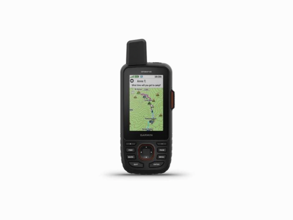
Garmin GPSMAP 66i Handheld Hiking GPS & Satellite Communicator front view

Garmin GPSMAP 66i Handheld Hiking GPS & Satellite Communicator rear view without carabiner back view. This unit comes with a carabiner mounted to the back which I hang off my pack

Garmin GPSMAP 66i Handheld Hiking GPS & Satellite Communicator side view without carabiner. The emergency button is located under the flap marked SOS

Garmin GPSMAP 66i Handheld Hiking GPS & Satellite Communicator on the left shoulder strap of my pack. This means that in the unlikely event that I am injured, it is within easy reach

Garmin GPSMAP 66i Handheld Hiking GPS & Satellite Communicator. There is a ‘share location’ option which is one of the biggest advantages of the inReach family allowing those who the user has nominated to follow them with or without a time delay. The time delay is good if you are opening up your trail to the general public as I do. This image shows my last day on the East Gippsland Rail Trail where I covered 34 km

Part of the same image as above but zoomed in

This image is at the closest zooming to about 30 metres. Not only does this allow family and friends to see where you are geographically but it also shows the terrain which gives them an idea of what you’re experiencing
We Like
- So many features!
- Long lasting battery
- A large colourful screen
- The two way communication ability is awesome and one of the main reasons I love the inReach units
- Two way emergency contact. If you press the SOS button you have the ability for contact with rescue services via text
- The tracking ability provides peace of mind for family and friends
- Replaces the functions of my old GPS and PLB with one unit
- Preloaded with maps
- The Iridium satellite network which has the widest coverage worldwide
- Relatively simple to use
- Your subscription fees can be on a yearly plan or month to month. You choose!
We Don't Like
- The purchase price is not your only cost. If you want the full features then you need to pay extra
- The initial purchase price is expensive
- Texting conversations through the Garmin unit is fiddly. Pair with a phone for the easiest texting
- With so many features on this unit you really do need to read the instruction manual
Best Uses
A great GPS for just about any activity, hiking, biking or boating where you want to provide peace of mind to family and friends
Buy One
The Garmin GPSMAP 66i Handheld Hiking GPS & Satellite Communicator is almost I’m possible to find but you can find the newer model, the Garmin GPSMAP HiI Plus Handheld GPS at Wild Earth
Disclosure: We may earn a small commission, at no additional expense to you, if you click through and make a purchase. Please note that our affiliations do not influence, in any way, the independence of our reviews. If we don’t like a product, you’ll hear about it from us!
Investment
Unit Purchase
- $871.00 AUD
Activation Fee
- $49 AUD (one off Charge)
Basic Weather Charge
- Charged as one text message
Premium Weather Charge
- $1.50 AUD per forecast
Additional Text message once you exceed you monthly allotment
- $0.75 AUD per message
SEE FEE CHARGES BELOW

Garmin InReach subscription fees as at 16 July 2023
Other Versions
Garmin produces a large range of GPS models to suit just about any activity you can imagine.
What happens when you activate the Emergency SOS button?
What happens when you set off an inReach?
Disclaimer
This review was done with product purchased from a retail store by Australian Hiker
Last updated
9 January 2026