Main Range Walk NSW (22.4km)
Kościuszko National Park
Nearest Town
Charlotte Pass, NSW
Best Time of the Year to Travel
- For newer hikers December-late March
- For experienced hikers that can cope with snow conditions and navigation off trail – year round
Starting Location
Charlotte Pass and the end of Kosciuszko Road
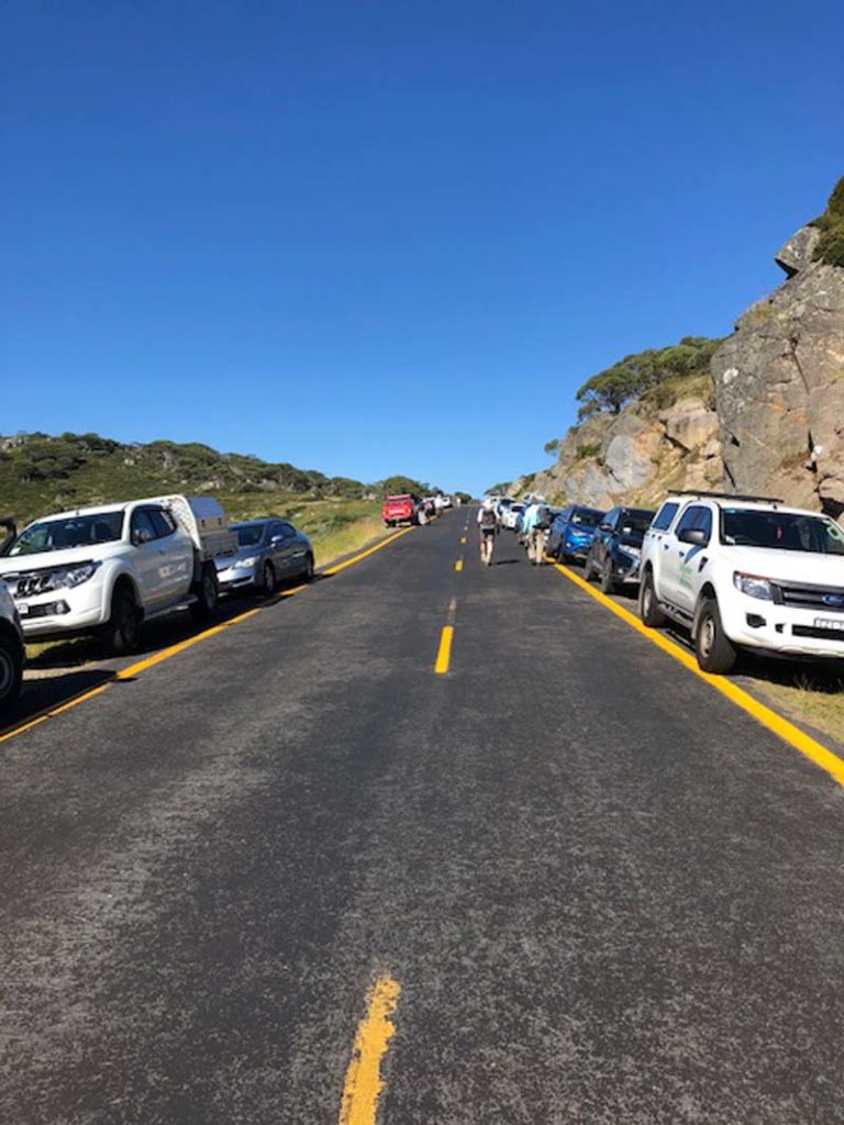
Three trails start from this trail head which means that it can be busy. I had to park around 500metres down the road on this busy Australia Day long weekend

Main Range Trail Head
Finish Location
Charlotte Pass and the end of Kosciuszko Road
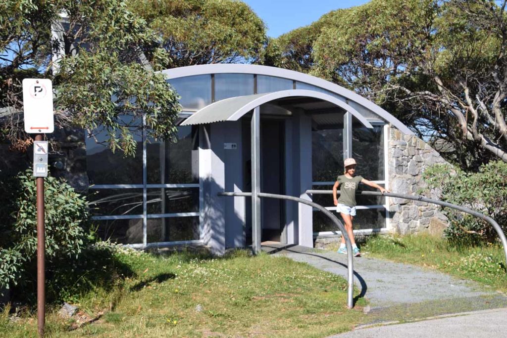
The toilet facilities at the trail head are excellent
Main Range Walk Review
My original plan was to do this walk in a single day and follow this up with another hike (the Mount Kosciuszko Summit walk) starting in the afternoon with an overnight stay. NSW Parks suggest doing this walk as a 7-9 hour trip being just over 22km. As such I expected that I would only see keen day hikers or those planning on doing this trip as a multi-day trip. I was surprised to say the least to come across approximately 80 other walkers on this trail, many of which were very obviously not hikers and who weren’t carrying any equipment apart from very tiny packs, or in some cases nothing at all.
Don’t get me wrong I have no issue with small packs but given what they were wearing I’m convinced the packs didn’t contain the necessary equipment to cater for poor weather conditions that can occur in the Australian alps. It had been at least seven years since I last hiked this area and on that visit which was at Christmas time, the temperature plummeted from 27° degrees celsius down to 4° celsius in a matter of a couple of hours due to a storm front that had pushed through. Even on this trip the forecast two days before was not looking promising with lightening storms forecast for the entire weekend. Thankfully the day before the conditions improved and away I went. The weather conditions in the Australian Alps can be very unpredictable so make sure you pay close attention to the weather forecast and come prepared for the worst just in case.
You can start this trail by hiking either direction and I must admit that my only reason for starting this trail in an anticlockwise direction was made prior to my arrival and based on the plans for my second hike. This trail head also steers you towards hiking in an anti clockwise direction but that choice is really up to you. The first part of this trail is on mainly paved trail and apart from the first 500 metres, which is a downhill stretch, is mostly all up hill. Just before you start the uphill stretch you will cross two river sections which rely on you nimbly stepping your way across well placed stones. There are warning signs that advise against this crossing if the stones are underwater which would be likely during full snow melt or after heavy rains. After these river crossings you have a relatively steady uphill run to reach the top of the main range which does take a bit of effort given its so early on in the hike. By world standards Australia’s highest mountains are pretty small but with a minimum altitude over 1700 metres it does require more effort than you would normally expect it would do if you were at lower altitudes closer to the ocean.
If you hike this trail outside of snow season then is almost impossible to get lost and this would explain the minimum amount of directional signs on this trail. The trail is very obvious and consists of paving stones or formed trail as well as sections of trail that appears relatively natural . Once you summit Mount Kosciuszko your return trip is via a management road which branches off at Rawson’s Pass at Australia’s highest toilets to either take you back to Charlotte Pass or to the chairlift don to Thredbo. This management road is probably the least exciting section of the trail but it does take you past the historic Seamans Hut as well as crossing over the Snowy River which provides an opportunity to dangle you feet in the cold water. This trail will take you in a loop that returns you to the Charlotte Pass car park where you started. The return trip from Mount Kosciuszko to Charlotte Pass while forming part of the Main Range walk is also the Mount Kosciuszko Summit Walk.

Early summer is the best wildflower season but even in mid summer there is a good show

Yellow daisy
While animal life is minimal in the alps the thing that makes up for it is the wildflowers and alpine vegetation which is different from most other areas in Australia that we are used to hiking in. The trees are almost non existent except for when you start and finish this trail. Most of the Alpine vegetation consists of grasses, wildflowers and low shrubs that cope with the extreme winter conditions. Peak wildflower season is early summer but depending on the weather you will often find that there is some snow in patches that is present almost year round and its only real in mid-late summer that you can be reasonably guaranteed to have snow free hiking.
Last and no least this walk provides some spectacular views from the roof of Australia. While Mount Kosciuszko is our highest mountain you will need to fight of the tourists trying to take their photos on out highest peak but by undertaking the Main Range Walk to will get equally excellent views from many other vantage points that the majority of tourists never see.
I did this walk in just on 5.5 hours so provided you have the fitness and ability a single day trip is not difficult. However if you want a more leisurely pace or aren’t into big days you can allow two to three days and camp as you go; the choice is yours.
This is a great walk one that everyone who has the opportunity should do at least once. Just remember to take a descent camera to record those spectacular views!

Start of the walk. There is nothing worse than a steep down hill section before you have to go up hill

River warning sign. Take care with your balance to ensure you don’t end up in the river

There are two river crossing just after you start this trail

Path example at the start of the trail. The first section of this trail is pretty much an uphill climb. While the early sections of the trail are paved the track is in pretty good condition

This trail has limited signage including at the trail head and most, but not all concerns the environment. Directional signage is not really necessary as its very obvious which way you should be going but become more common as you each Mount Kosciuszko

Stylidium sp – Trigger Plants. These plants are wide spread throughout Australia and I love coming across them in any location

Pockets of snow are present even into mid summer

Take a detour off to Blue Lake if you feel so inclined

While the first section of the trail is well paved it becomes more rustic once you get past the Blue Lake turnoff

Once you go past the turn off to Blue lake you then have another uphill section that takes you along the roof of Australia
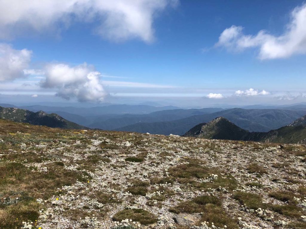
The views are spectacular without all those annoying trees to get in the way.

Who says Tim doesn’t smile?

What goes up must go down before going up again. That’s one of the unwritten hiking rules

The Alpine ecosystem is a fragile environment so keep of the grass where directed

The March Fly’s will bite through socks as well as thinner tops. I would advise against wearing shorts or short sleeved shirts on this walk as they are very peristant

Albina Lake

The trail section near Albina Lake gets very rustic

In this image you can see large numbers of people on the summit of Mount Kosciuszko. The day this image was taken I counted around 150 people. Around 100,000 people summit Mount Kosciuszko each year

The turnoff to the summit of Mount Kosciuszko. At this point the Main Range Walk merges with the Mount Kosciuszko Summit walk

You will often see large ‘murders’ of crows species in this part of the alps. They don’t seem to mind having their photos taken in large groups

The challenge is trying to take photos of two together

Because this was Australia Day there had been a poetry reading just before this image was taken so there was a large number of tourists lining up to have their photos taken at highest point

Just some of the 150 tourists on the summit of Mount Kosciuszko give or take a few!

Australias highest toilets at Rawson Pass on the way back to the trail start
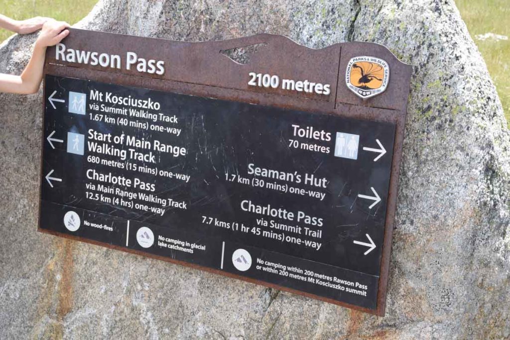
The sign returning you to Charlotte Pass

The trail from the summit of Mount Kosciuszko to the trail head is on a management trail. Note the height of the trail markers on the road edge (3 metres) to take into account winter snow
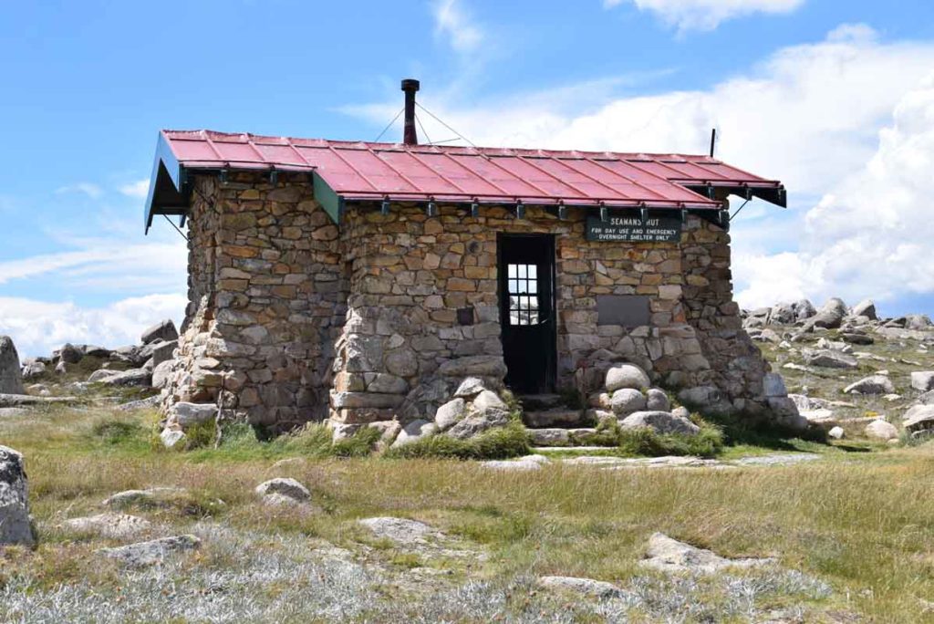
Seamans Hut is approximately 3km from the summit of Mount Kosciuszko. This hut is for day use or emergency use only and provides a bit of history lesson

Snowy River crossing. Many hikers that I came across had taken the opportunity to soak their feet in the cool water

As you approach the trail finish you will make out the starting trail winding into the hills

Trail finish back at the Charlotte Pass car park. The toilets are to the right and the parking is straight ahead down the road.
Getting There
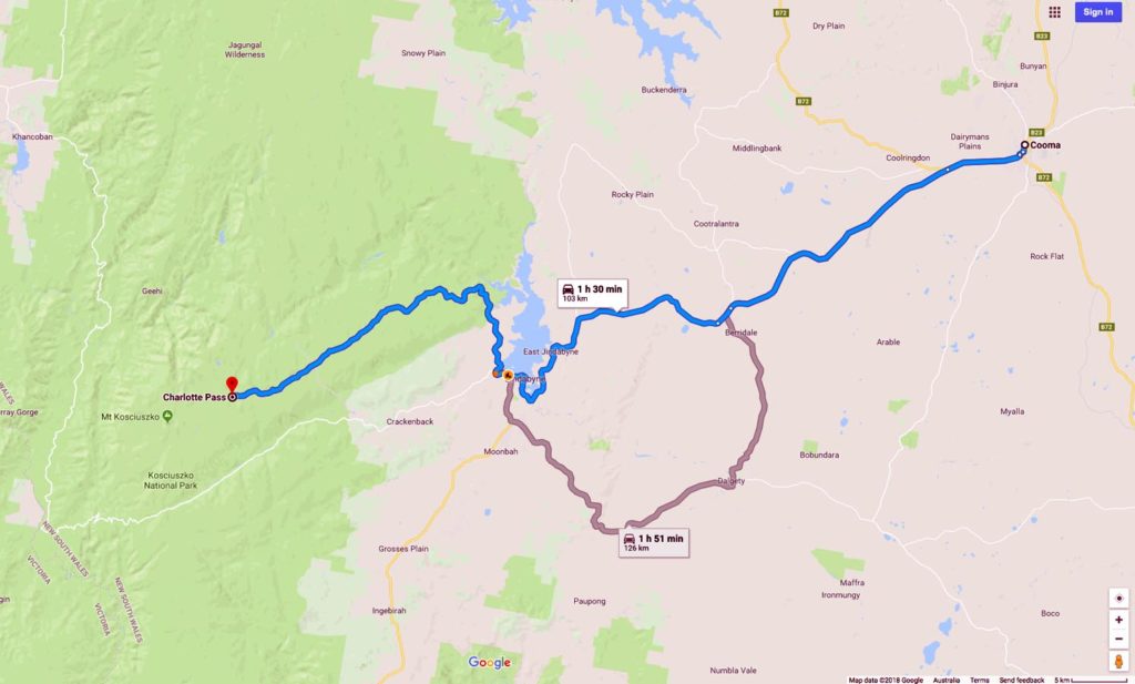
Travel to Jindabyne via Cooma and head towards Charlotte Pass. There is a park entry fee which you can pay for as other a day or annual pass either at the visitor centre in Jindabyne or at the toll gates on nearing the park. The visitor centre in Jindabyne opens at 8:30am most days but check the timings on the website just in case.
- Follow Kosciuszko Road until it ends at the carpark at Charlotte Pass. Long term parking is along the road but there is 20 minute parking to allow you time to offload gear if you need to. If you want to avoid most of the crowds on busy weekends start walking around 8:00am which will allow you time to get a good park
Things to Know
- Phone: There is some phone signal on this trail (Telstra) but it is limited
- Water: You need to bring your own water. There are some locations to draw water on the trail but this tends to either be early or late in the trail.
- Toilets:
- The are three sets of toilets on the trail are at the trail head, Seamans Hut, and at Rawson’s Pass near the summit (Australia Highest Toilets)
- Trail:
- This walk is an ‘loop’ experience
- This trail consists of formed track and some small sections of management road
- Dogs: No dogs allowed
- Camping: Allowed in most but not all areas. You can purchase a map at the Parks Office in Jindabyne which will identify the no campi\ng areas
- Other:
- The March Flies are ruthless from about mid November-Mid March so wear long clothing. They don’t care about insect repellent
- The Australia Day weekend in January is a very popular time to walk this trek. If you planning on walking on this weekend start early to avoid big crowds (before 8:00am)
- If you plan on camping be aware of the restrictions regarding where you can camp
- Come prepared for bad weather conditions and low temperatures at ant time of the year even if its not forecast
Disclaimer
This walk was undertaken by the team from Australian Hiker