London Bridge Walking Track NSW (2.7 km)
Googong Foreshores
Nearest Town
Queanbeyan
Starting Location
London Bridge Woolshed carpark

London Bridge Woolshed carpark
Finish Location
London Bridge Woolshed carpark
Best time to Travel
Year round
London Bridge Walk Summary
This walk, mainly through what used to be farmland, is relatively unknown amongst Canberra residents due mainly to the better known walks in the Namadgi National Park. Close to Canberra, this walk is relatively short and very easy with the most difficult part being the creek crossing. If you don’t feel like crossing the creek and doing a loop you can always turn around and go back the way you came. It is also a good area to bring tourists as Kangaroos can be pretty much guaranteed except maybe in the hottest part of summer days where they will be resting in the shade.
As the name suggests this is a ‘bridge’ like structure and while you used to walk over it this is no longer possible. Please ensure your safety and respect the cultural and environmental value of this location by using marked walking tracks only. The best views of the natural structure is down at creek level. Follow on the road and cross the shallow creek (this creek can be deeper during periods of heavy rain) and the road will loop back to the starting point. You also have the opportunity to walk to the old homestead if you wish which is an extension to the walk..

Trail roster. The starting point for this walk is at the woodshed. The area has gas barbecues, small shelters and toilet faculties. Great for a barbecue lunch at the end of the walk

An example of the interpretive signage at the Woolshed

Toilet facilities at the trail head

Shearers quarters and BBQ facilities at the trail head

Close up of gas BBQ at the trail head.There are two of the BBQ shelters in this area and both have a couple of bench tables for the family

Woolshed

Looking back from the trail after starting and finishing the walk

Leaving the trail head paddock

Do’s and dont’s on the trail

Heading down to London Bridge

Warning signs

The Arch looking down from the cliff top. Keep away from the edge as it is unstable
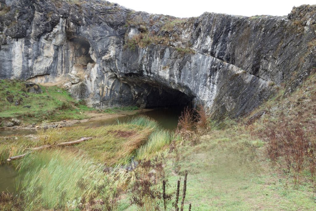
The London Bridge Arch. This Arch gives the walk and the area its name. please note that since we did this walk in 2017 it is no longer possible to walk across the arch.
Getting There

How to get There: Leaving from Queanbeyan take the Old Cooma Road before turning left onto Burra Road. Travel approximately 7.8 km and turn left onto the London Bridge Road. Stay on the London Bridge Road until you reach the London Bridge Woolshed Creek car park
WARNING: If you are using Google maps to reach the woolshed enter the destination as ‘London Bridge carpark’. If you enter ‘London Bridge Homestead’ you will end up coming in from the rear end of the homestead which means you are parking in a farmer’s paddock

Turnoff point from the Old Cooma Road onto the Burra Road. From here the turnoff to the London Bridge Road is 7.8 km

Turnoff onto the London Bridge Road

When you reach the end of the bitumen follow the signage to London Bridge

Go through the closed gate and follow the signs

Be conscious of the opening hours particularly if starting early or finishing late

Opening times for this area

Plenty of parking available at the trail head
Things to Know
- Phone: There is minimal phone signal on this track (Telstra)
- Water: You need to bring your own water or else a filter
- Toilets: There are toilets located in the picnic area at the trailhead
- Trail: This trail consists of formed track
- Dogs: No dogs allowed
- Other:
- This walk is done in a loop
- Avoid the summer months – it is very, very hot at that time
- Opening hours are 8:00am-5:00pm but check on the ACT Government website prior to going
- If you are using Google Maps to reach your destination enter the as ‘London Bridge carpark’. If you enter ‘London Bridge Homestead’ you will end up coming in from the rear end of the homestead which means you are parking in a farmer’s paddock.
- Keep clear of the edges when crossing London bridge as the edges can be a bit soft. Keep young children close and safe on this walk
- While this area is managed by ACT parks as part of the Googong water Catchment area the Googong area is actually located in NSW rather than the ACT.
Disclaimer
This walk was undertaken by the team from Australian Hiker