Bondi to Manly Walk NSW (80km)
Sydney City
Nearest Town
- Northern Trail Head: Manly
- Southern TrailHead: Bondi
Starting Location
- Northern Trail Head: Centre of Manly Beach
- Southern Trail Head: Centre of Bondi Beach

Manly Trail Head
Finish Location
- Northern Trail Head: Centre of Manly Beach
- Southern Trail Head: Centre of Bondi Beach

Bondi Trail Head
Best Time of the Year to Walk
Year round but try to avoid the extreme hot days in mid Summer if doing long distances. Also avoid stormy conditions when accessing narrow beach crossings
Bondi to Manly Walk Review
The ability to walk from Bondi Beach to Manly Beach along the Sydney coastline has long been an option but in December 2019 this route which informally connected a series of pre-existing walks was formalised into a standalone walk. Perhaps the biggest impact of becoming an official walk was the availability of resources to plan, making it much more accessible to both local and interstate hikers. In March 2020, I finally managed to organise the time to do this walk and although I planned to complete this track in two days, a number of factors turned this into a three day walk.
While this walk is a very much a ‘choose your own adventure’, if you are travelling from interstate with a time limit. then I would suggest you look at a time frame of 3-5 days. If you live in Sydney you can take as long as you like. This article discusses my three day trip, makes suggestions on start and end points, and provides other logistical recommendations I suggest having now completed this walk.
How long you take to complete this walk will really depend on the time you have, how fit you are and how much exploring and playing you want to do along the way. It really is wide open to how you do it! One thing to note here is that because this walk is called the Bondi to Manly Walk, it appears that most hikers will start at Bondi Beach and finish at Manly Beach. I have a preference for ‘walking home’ so it was always a no brainer that I would start at the Manly end. Having said that, I was a bit of a rarity – every other walker I came across was heading north, and there were a lot of them.
Please note that the podcast on this trail can be found HERE
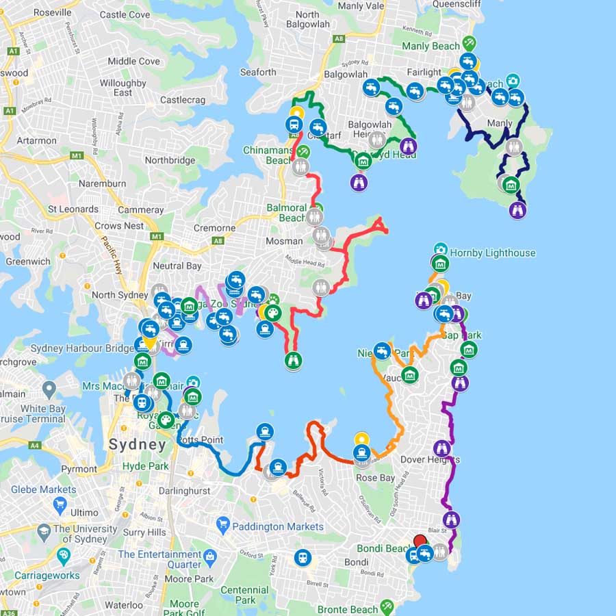
Bondi to Manly Track Map. Look at the section close in to the Opera House and the Sydney Harbour Bridge (towards the left of the map) where you weave in and out of lots of smaller bays
Day 0
Being a Canberra local I needed to travel to Sydney to start this walk and I wasn’t alone in this given that I came across a large group doing the same thing.
I opted to catch a bus from Canberra on the Thursday evening, arriving at my hotel in Manly at just after 9:00pm. I chose a Manly hotel so I could walk across the road to start my hike. In hindsight, I wouldn’t do this again as accomodation in Manly, close to the beach, was the dearest of my three nights, and being a pub it was very noisy until 11:00pm. Instead I would opt to stay two nights at my night two accommodation in Cremorne (see below) and get an Uber/Taxi to the trail start in the morning – this would have worked out cheaper.
Day 1
An early start to the day and breakfast with most of the cafes opening at around 6:30 am. I had a very pleasant breakfast at a local cafe sitting at the tables on the sidewalk watching the world go past. I was stunned at the number of people already out and about walking, jogging, swimming and playing volleyball.
After breakfast I headed back upstairs to pick up my pack and head off only to discover my electronic room key no longer worked. I managed to track down a staff member who eventually let me inside but not before a 30 minute delay which is not something I wanted on a day I was planning to walk 40 km.
I headed over the beachside promenade to look for an obvious trailhead and even with the use of the dedicated smartphone trail app, discovered there was no such thing – the point the app takes you to is the centre of the Manly Beach promenade. While not critical it would be nice to have a dedicated trail head sign that promotes the trail and highlights the key things you will see. Off I go heading towards North Head through the bushland.
I expect to see lots of trail markers to direct me but no such luck. While there is a dedicated trail logic, it’s not always used and not always obvious. In fact within half an hour of starting I take a wrong turn thinking I am on the right track but soon discover I’ve just done a small loop of parkland and I should have turned right rather than left. In the process I manage to annoy an Australian Brush Turkey who persists in trying to get away from me by walking directly in front of me. The Brush Turkey is by far the most common wildlife I see over the next three days and the big brightly coloured males are quite happy to get very close. The females and younger males however will escape into the bush or fly up onto a low overhanging branch to get away.
After this little incident I start using the app a lot more and am paying very close attention to where I’m supposed to be going. Back on track again and I make my way through the military heritage on North Head which is a first for me. I learn early on that the point of this trail isn’t to get to Bondi Beach by the shortest possible route but rather to see as much of Sydney Harbour and the nearby ocean as the trail will allow. This means I have coastal views for much of the next three days.
This first day is very consistent passing through bushland, parkland, beach and residential area. Day one works out being the least amount of time spent in amongst residential houses and in many respects my favourite day, but only just. This walk connects a series of pre-existing walks and uses residential connections where needed.
By mid morning I’m on the Manly to Spit Walk which I’ve done previously. This 10 km walk is very popular and there are a lot of people walking even though it’s a Friday. I find by late morning that I’m struggling and can’t quite work out why. I soon realise it’s a combination of being the heaviest weight that I have ever been, I’m lacking in fitness, and that I haven’t eaten for quite a while so I have run out of energy. I take a break on a timber bench at the top of a rise, have a lay down and eat some food.
Once I start up again I’m moving much better and am now forcing myself to have small quantities of food every 30 minutes which has fixed my lack of energy. It’s been some time since the last time I did a long hike so I’ve gotten out of the routine of eating regularly on shorter hikes. I soon realise this two day hike is going to turn into a three day hike. I had allowed plenty of time up my sleeve so it doesn’t worry me too much.
On I press. The rain has created some large puddles on the track which I manage to skirt around but the plus side of the rain over the past few days is that there are some small ‘waterfalls’. Just after I cross Spit Bridge the traffic comes to a halt and I realise the bridge is being opened to allow boats through. I’ve been up this way a few times but Have never seen the bridge raised before. While I’m there I take advantage of a great little takeaway joint just past the bridge and have an afternoon tea break, my second in the past hour!
I’m off again making my way past suburbs on my left and water to my right, and now I’m at Middle head. This trail out and back is almost identical and heading out to the head itself I pass through a gate that warns walkers the gate will close in the early evening. This isn’t an issue for me as I won’t be returning the same way but you could get caught out if you are coming the other way and don’t realise the gate will be locked. Middle Head isn’t as good as North Head from a heritage perspective but it’s definitely worth a visit all the same.
I start thinking about where I’m going to stop for the day as you can’t legally camp on the track and as such I need to get a Taxi/Uber to my hotel of choice which I haven’t as yet booked. I decide to stop at around 4:00pm and this works out to be the Gunners Barracks not far before Chowder Bay. In hindsight I would have pushed on for another 1.5 km and finished my day at the Chowder Bay Park which is large and easy to find.
Overall this has been a really good day with an excellent view of the harbour, some great bushland and a chance to see parts of Sydney I hadn’t seen before.
My Uber arrives and takes me to my accomodation (see below) at Cremorne which is about 2.5 km off the trail. I could potentially walk it but it’s been a long day and the ride is pretty cheap. I check in and go to buy some snacks and breakfast for the next day, and then pick up a pizza. I’m now nice and contented, and while I have things I need to do, I watch some TV and head off to bed for a very good night’s sleep.
Breakfast just off the beach and watching the world go by

Trail at Manly

Epacris in flower

Banksia in flower on North Head

Eucalyptus in flower


Magpie in mid flight

North Head

Memorial Path on North Head

Old Gun on North Head

Rock shelf along the water

Manly Beach

View from the headland on the Split to Manly section of the walk

Aboriginal rock carvings (Petroglyphs)

Trail example approaching Spit Bridge
A couple of days of rain creates some lovely little waterfalls as i head towards the Spit Bridge

Spit Bridge raised for boat to pass through

Afternoon tea on day 1

Gate closing sign

Middle Head

Heading up the hill from Middle Head
Day 2
I wake up around 5:15am and eat breakfast. I’m back at the trail before 7:30 ready to head off again. I make my way down to Chowder Bay and realise that if the tide had been very high or the sea conditions rough, I would have ended up with wet feet. I also have to work out how to get around the pump house, or walk through water and thankfully a local walking her dog shows me the way – we find a trail that is almost hidden that runs behind the pump house itself and takes you down to the park level. From here I’m back in bushland again for much of the morning as I make my way past Taronga Zoo.
I’m now starting to get good views of the city and eventually the Opera House and the Harbour bridge as I make my way towards the end to the northern section of this track. I also have views of two giant cruise ships, one in the middle of the harbour waiting its turn to berth and the other at Circular Quay itself. There are so many headlands and so many good views that I stop taking photos. Having said that I still take almost 500 photos over the three days.
I have never been up close to Admiralty House at Kirribilli before and realise why this has such a good reputation as an official residence – the views are spectacular! Again I have to pay very close attention because many of the turn signs are small and not so obvious. I walk past a laneway that I’m supposed to turn down and have to turn around and come back. I’m now walking along the harbour making my way towards the Sydney Harbour Bridge and before I know it I’m crossing over one of Australia’s best known icoms for the first time in my life.
There are a lot of people walking over the bridge and the traffic is noisy; I pity the security guards stationed along the bridge at various intervals and wonder how long are their shifts. Now I’m making my way past the Rocks into Circular Quay. The app fails me for the first time because the ‘official trail’ is blocked off due to a cruise ship that’s in the Harbour which is loading around 2,000 passengers which are lined up all the way back into Circular Quay itself. I’m not a fan of crowds as they stress me so I make my way through the Quay as quickly as I can before stopping for lunch on the side of the Opera House.
As I leave the Opera House I enter the Royal Botanic Gardens and think there must be a concert on as I can hear loud music but soon realise there are a number of yachts tied together having a party with the music blaring away. I make my way past the naval base at HMAS Kuttabul and for the first time I can’t follow the Harbour.
I keep on walking past Potts Point, past Double bay and I’ am stunned at the real estate in these locations. I can see why it costs so much given the views of the Harbour. I expect to stop at around 5:00pm today but stop again for afternoon tea at Rose Bay. I check my map and identify Nielsen Park in Vaucluse is the best option. Once I stop I select my accomodation for the night in Potts Point and I walk about 80 metres to the hotel. Again I base my choice on somewhere close to good meal options, that also has a good reputation and price to go with it. I settle in for the evening with an early dinner.
Today was a very different day to yesterday walking past a huge range of upmarket suburbs in the central part of Sydney as well as walking in and out of lots of little bays and small headlands. I realise that my GPS is set on a fairly course setting and it is under reading by at least 5-7 km which means I’ve done around 35 km today and I’m definitely feeling it.
Overall a very enjoyable day.

Brush Turkey, these big colourful males don’t seem to care about walkers whereas the juveniles and females move away when approached

Not yet high tide. If the weather was bad and/or the tide was high then you either get wet or find another route

Pumphouse at Chowder Bay

Sub base Platypus

Down the stairs to the sub base

Catching sight of the Opera House and the Sydney Harbour Bridge for the first time

Admiralty House at Kirribilli

Sydney Harbour Bridge

Crossing Sydney Harbour Bridge

‘Bite me” this appears a bit odd at first until you realise that it is promoting carniverous plants

Artwork on the trail

Afternoon tea day 2

Nielsen Park. The end of day 2
Day 3
Day three and I’m up and off again starting my walk back at Nielsen Park at just on 7:30am. It’s raining when I start so once I get out of my Uber I put my rain gear on – the only dry location is the women’s toilet that has a large overhang.
By the time I’ve caught up on my social media posting, the rain has stopped. Off again I go and after a short bushland walk I’m back out into the suburbs again heading towards South Head. Again South Head has old military heritage and even though that’s the field I worked in for a number of years, I was surprised to find that the earliest gun placements were installed in the mid 1800’s when we worried about the colonial aspirations of the French.
Once I leave South Head I’m travelling on the walk that runs along the cliff tops so again, day three is a very different day from the two previous days. The paths are nice and wide, and the trail for most of day has the least change in altitude. The views out towards the ocean are excellent. I make my way along the cliff top trail and start to think this walk is going quicker than planned. Sure enough I come across a sign that says I only have little over an hour to go which will finish me before lunchtime. It’s time for a panicked call to Gill who is driving up from Canberra to pick me up but I had arranged to meet her at Bondi around 3:30pm this afternoon and while I have things I can do, I’d rather be doing them at home.
I reach Bondi Beach at around 11:15am which means I have walked less than four hours today. I could have completed this walk in two days but I’m glad I took three days.
I walk along the promenade on Bondi Beach taking in the scenery and again I have my phone in hand so I can stop at the trail head. Just like Manly, this turns out to be the middle of the beach at a warning sign but otherwise no major fanfare to say you have finished. I make my way across the road to McDonald’s and set myself up for the next few hours waiting for Gill to arrive and catching up on my social media posting.

Parsley Bay Bridge
Parsley Bay Bridge

South Head Lighthouse

South Head gun placement

Looking from South Head to North Head
The view from South Head

Cliff top at South Head

Dunbar wreck anchor on South Head

Bondi Beach

Bondi Beach Pavillion
Bondi Beach Trail Head
Last Words
I think the images and videos do better justice to this walk than my text or podcast ever can. The Bondi to Manly Walk is without a doubt one of the best walks I have ever done. Over the coming weeks I will add it to the Australian Hiker Top 10 Favourite Hikes list– it’s that good. While I already have a couple of other walks in the Sydney region planned for 2020, this walk has excited me to the opportunity of what Sydney has to offer in particular on the longer coastal walks. In addition to what I already have planned, I will be adding a few of the other Sydney walks to this year’s review list.
Track Resources
- Bondi to Manly Website
- Bondi to Manly interactive map
- Bondi to Manly Iphone App
- Bondi to Manly Android App
- Bondi to Manly Website itineraries 2,4,5 and 7 days
Signage
This trail only opened in December 2019 so I expect there is still work to be done. My key negative on this trail is the signage. There needs to be more prominent trail markers at each of the trail heads as well as better consistency on the trail signage throughout the trail including at those key decision and turn points where you shouldn’t have to be thinking about which turn to take. The signage doesn’t vary greatly throughout the 80 km track and wouldn’t take too much to improve it. The images below show the types of signage you can expect on this track.

Footpath signage

Footpath emblem

Little hiker strip. These little strip appears in random locations and are very easy to miss

Signage example. Look for the styalised whale

The signage location always varies

Large signage on North Head

Older signage on the trail

Cliff walk sign, heading towards Bondi
Accomodation
Everyone has different requirements as far as accomodation goes. I’m too old to bother with backpackers but I also don’t want to spend $400 a night on accommodation either. Having said that you can choose the level of accommodation you want based on your requirements and budget. My key requirements are:
- Reasonable price
- Own bathroom
- Close to supermarket, restaurant and cafes
Based on my trip, if I travelled up to Sydney the night before and did this as a three day walk again, I would stay at the following places. Please note that these two hotels suit my budget and my likes but they may not suit yours so take them as a suggestion only. I booked both of these places online and on the day I turned up but I wouldn’t recommend that if there are major events on in Sydney:
- Night 0+ 1
- Night 2
Food
There are enough cafes, restaurants and shops along this trail that you really only need to take basic snacks with you and if you want, buy your meals as you go.
- I had breakfast on day one at Little Bellgrave at Manly just across from the beach
- At the recommendation of the hotel, I went to Marilynas Famous Pizza in Cremorne for a takeaway pizza on night 1 and I found it to be well worth the visit. There are also Thai, Indian and a number of other restaurants all in close proximity to the hotel.

Little Bellgrave at Manly for Breakfast
Water
The Trail app has water fountains identified on the map. I usually prefer to use a water bladder so will carry three litres at the start of the day. You can however fill up water bottles very easily as you go

Water bubbler on the trail
Transport Options
The easiest way to get from the track to your accommodation each night if you aren’t a Sydney local is either via Taxi or Uber. You just need to ensure that your pick up point is on an easy to locate road
Getting There

The southern trail head in Manly is a 30 minute drive from the Sydney GPO depending on the traffic

The southern trail head in Bondi is a 20 minute drive from the Sydney GPO depending on the traffic
Things to Know
- Water: Water is available at various points along the trail but if it’s hot, carry at least two litres
- Phone: There is good phone signal on this trail (Telstra)
- Toilets: There are toilets on the way on this trail
- Trail: This main walk is on sealed trail. Once you go off-trail to the JC Slaughter Falls the trail becomes natural
- Dogs: Dogs allowed on leash
- Other:
- There are no trail registers on this trail
- No camping is allowed on this trail
- Bring fly repellent in the hotter months
- Bring adequate shade (hat, long sleeves etc) in the hotter months
- No camping is allowed on this trail
- Pay close attention to the trail because the direction you need to head is not always apparent
- Keep an eye of the tides particularly if the weather is very windy as some beach crossings may be a bit awkward
Disclaimer
This walk was undertaken by the team from Australian Hiker