Spit Bridge to Manly Walk (9.6 km)
Sydney Harbour National Park
Nearest Town
- Mosman, NSW at the start
- Manly, NSW at the finish
Starting Location
If you are a visitor or need to travel by car, then the carpark on the southern side of the bridge on Spit Road at the Spit Reserve is the best starting point. If you are a local, one option is to catch the ferry to the Manly Wharf, walk to Spit Bridge, then catch a bus or taxi back to the ferry terminal

Spit Reserve Carpark at D’Albora Marina
Finish Location
Manly Wharf. Then a taxi/car ride back to the starting point at Spit Bridge
Best Time to Travel
Year round but try to avoid high tides where possible to keep your feet dry
Spit Bridge to Manly Walk
One of Sydney’s great hidden walks with many locals being unaware of its existence. This walk provides a great opportunity to do a medium length walk (10 km) without leaving the city. Depending on your transport needs and whether you plan to do this as a return trip, the best starting location is at the Spit Bridge end located near the D’Albora Marina on Spit Road. The parking facilities are good, but expensive, and provided you make an early start. you will get one of the limited car parks. Alternatively you can start this walk at the Manly Wharf end and either walk back making for a 20km walk or get return transport.
The walk starts by walking over the Spit Bridge with the trail weaving through bushland along the harbour. The trail passes along residential suburbs near the waters edge and for much of the track you could be forgiven for thinking you are in remote bushland. You also have beach walks along the way.
The walk is well sign-posted and takes around 2.5 hours for fit active walkers to complete although is you want to take your time and swim along the way allow about 3-4 hours.
There are great views both directly of the harbour and with glimpses of the harbour through the lush vegetation that encompasses the track. In addition there is plenty to see along the track with a good range of wildlife and native flora that is totally unexpected in a city of this size so bring your camera. It’s worthwhile bringing your swimming gear so in the warmer months you can take a dip at Manly Beach at the trail end or at several beaches along the way. One thing to note that on occasion you will be walking along the waters edge so it is best to avoid high tide if the conditions are windy.
In addition to the waterfront and bush views about half way along the trail there is also an area of Aboriginal rock engravings that also contains graffiti from the 1940’s.
This is a great walk and one that I never tire of doing when I’m in the Sydney area.
Getting There
The best place to park is the carpark on the southern side of Spit Bridge on Spit Road at the Spit Reserve. If you start early you will have no problem getting a parking space however later in the day could become a problem.
Spit Reserve Carpark. The best place to start

Toilet facilities at the Spit Reserve

You will need to cross the Spit Road. If it is busy walk to the nearby traffic lights to cross

Trail example. This trail feels very remote in spite of its location

At high tide you will be knee deep. Alternatively you can avoid the beach by walking on the road

Wildflowers are plentiful

Eastern Water Dragon sunning itself on the track

In addition to the Aboriginal rock engravings there is Graffiti from the 1940’s

Male Bush Turkey. These guys can make one hell of a mess in the nearby gardens

Signage if easy to follow. Maps are not required

Fun on the beach
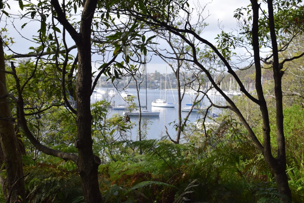
There are plenty of excellent water views along the trail

Eucalyptus bark, just one the little gems along the way

Trail end/start at Manly Wharf

Brunch was reward at the end of the track. There are some good cafes with views of the beach
Getting There

The best place to park is the carpark on the southern side of Spit Bridge on Spit Road at the Spit Reserve. If you start early you will have no problem getting a parking space however later in the day could become a problem.
Things to Know
- Phone: There is reasonable phone signal on this track
- Water: You can pick up water at various points along the way as well as the off cafe
- Toilets: There are a number of toilet facilities along the way
- Trail: This trail consists of formed track and beach walking
- Dogs: Only allowed on some sections
- Camping: No camping allowed
- Other:
- This walk is done in an end to end manner
- If the weather is warm then come prepared to swim if that’s what you’re into
- A one way (10 km) or return trip (20 km), your choice
- Very easy to navigate
- Come prepared to get wet if it is high tide
- Parking – Pay parking only. For the day is about $22 (weekdays) $27 (Weekends) as at 13 August 2025
Disclaimer
This walk was done by the team from Australian Hiker