Rennix Walking Track NSW (13.2km)
Kościuszko National Park
Nearest Town
Jindabyne, NSW
Best Time of the Year to Travel
- For newer hikers – November-late to March
- For experienced hikers who can cope with snow conditions and navigation off trail – year round
Starting Location
Rennix Walking Track car park, NSW

Finish Location
Rennix Walking Track car park, NSW
Rennix Walking Track Review
Over the past few years as I have been doing more and more walks in the Koscisuzko National Park and have repeatedly driven past the Rennix Walking Track so I finally set aside some time to do this walk. The trailhead signage, which has been there for a while says this walk is 12km but the National Parks website lists it as 13km. On the day we walked this track it end up being 13.2km and as a 13.2 km walk it’s a hard one, more on this in a moment. The car park for the Rennix Walking Track comes at you quickly so you will need to be paying attention to the signage on the righthand side of the road. As you turn off Kosciuszko Road, the drive to the car park is visible and only about 200 metres away. The trailhead is more of a dead-end so as you park allow other users enough space to turn around.
There is an old slightly faded information sign at the trailhead which provides good details on this walk – one key piece of information you need to be aware of is that your walk destination is actually the Radio Repeater which is about 800 metres past the TRIG.
Just after you start this walk you will cross a creek and depending on the time of the year and given the amount of rain we’ve had recently, you may get wet feet so come prepared for this. The entire walk is on management road that ends at the Radio Repeater so the trail is relatively easy to follow. Having said that this road isn’t used very much so is covered with grass and for the first 2km is very spongy – it feels like you are putting a lot of effort into walking without going very fast. The walking track is actually vehicle tread wide and with someone who has size 15 feet, its a little narrow for my liking which forced me back onto the spongy grass. The road eventually hardens up as you gain altitude and the walking does become easier.
The trail is generally a steady incline upwards with a couple of short steep sections along the way. There is plenty of variety as you go, sometimes walking in open grassy heathlands and other times walking through treelined areas. Animal life was limited on the day we did this walk which isn’t surprising given we were approaching the upper reaches of the tree line.
The steepest section of this walk, only a few hundred metres long, is the final descent to the ridge line that takes you to your destination. As you cross the ridge line and continue to follow the road, you will eventually see the TRIG marker and if there is any wind around you will hear the metal creak in wind. While you can walk the short distance off the trail, the TRIG itself sits on a large rock outcrop and difficult to get to so we opted to keep on walking to to final destination around 800 metres further on to the Radio Repeater situated on a large rock outcrop. Along the way you will be treated to views of Lake Jindabyne down below.
The road ends at the Radio Repeater so the destination is very obvious. Walk around the back of the Repeater and the rock shelf allows you easy access to the peak which is just slightly lower than the main summit TRIG. The views are pretty good form here but it can be pretty windy which is typical of the Australian Alps. Spend some time taking a break and taking in the scenery before making your way back to the start of the trail. By the time we started to head back down it was late morning and a hot day and the March flies were out in force – at one point I had five of them trying to bite me at the same time so I didn’t stand still for very long. As a result the trip back to the car park was much quicker – as an added bonus you can enjoy the views you didn’t notice on the climb up.
This is a very good but at times hard walk that has a possible camping destination if you want to do this as a two day walk although you will need to collect water along the way or bring it with you. Having said that water sources are limited so carrying it in is your best option particularly during the hotter months. If you are doing this walk in winter its good to have experience in snow travel and I would recommend you also consider snowshoes or skis if doing this in the coldest parts of the year.

Picnic table at Rennix trailhead

Tralhead information signage. Read this text as it provides more detail about the walk destination beyond the TRIG

Trail directional signage. There are very few of these but the trail is relatively easy to follow given you are on management road all the way. The road isn’t used very often so it’s a pretty grassy track

And away we go

Creek crossing within the first 100 metres. On the day we did this walk it was a dry crossing but after periods of heavy rain expect to get wet feet

The majority of the trail is a grassy management road. The first 2km is very soft and spongy and you feel like you are putting in a lot of effort to ravel a short distance, the trail eventually hardens up

In some areas there are deep ruts with a few being filled in to allow vehicle travel

Trigger plant

Trail example. There are a few steep uphill sections but nothing overly long or difficult

Tim taking a break on the Rennix Track

Royal Bluebell on track

This track varies between open and grassy to closed and treed

Gill on the trail

Oh so pretty

The hills in the centre left are our destination point

Views to the distance

Boy and girl grasshopper doing their thing

Approaching final peak

Female Katydid. The males which we came across for the first time had long wings and a narrower body. These are a hard thing to photograph as they will not stay still

Approaching the trig you get glimpses from the trail. On the day we did this walk you could hear it rattling in the wind. This is ‘a’ destination point but not ‘the’ destination point of this walk. Have a look around this area but then continue along the trail the the Radio Repeater

Lake Jindabyne in the distance

Rennix Walking Track Radio Repeater. The management road ends at this point. Walk up and sit on the rock ledge next to the Radio Repeater to get the views
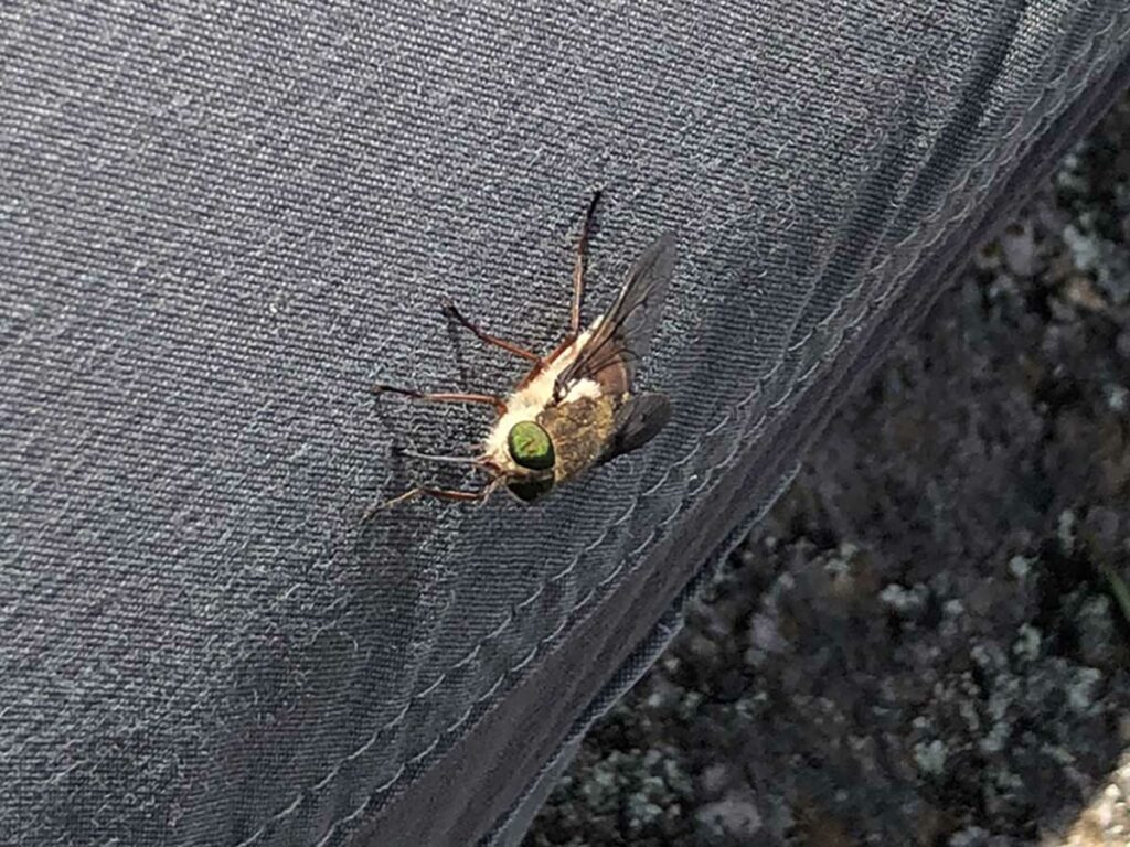
March fly. On the day we did this walk in late January they were brutal – I had five of them trying to bite me at once through my clothing! I didn’t stand still for any length of time

Head down towards the trailhead

Almost back to the Rennix trailhead

Back to the trailhead
Walk Video
This video includes a slideshow from start to finish of this walk that includes still and video images to give you a real time idea of what the walk is like
Getting There

Travel to Jindabyne via Cooma and head towards Charlotte Pass. There is a park entry fee which you can pay for as a day or annual pass at the visitor centre in Jindabyne or at the toll gates on nearing the park. The visitor centre in Jindabyne opens at 8:30am most days but check the timings on the website just in case.
Once you have entered the park follow Kosciuszko Road and keep and eye out for the Rennix Car Park on the righthand side of the road
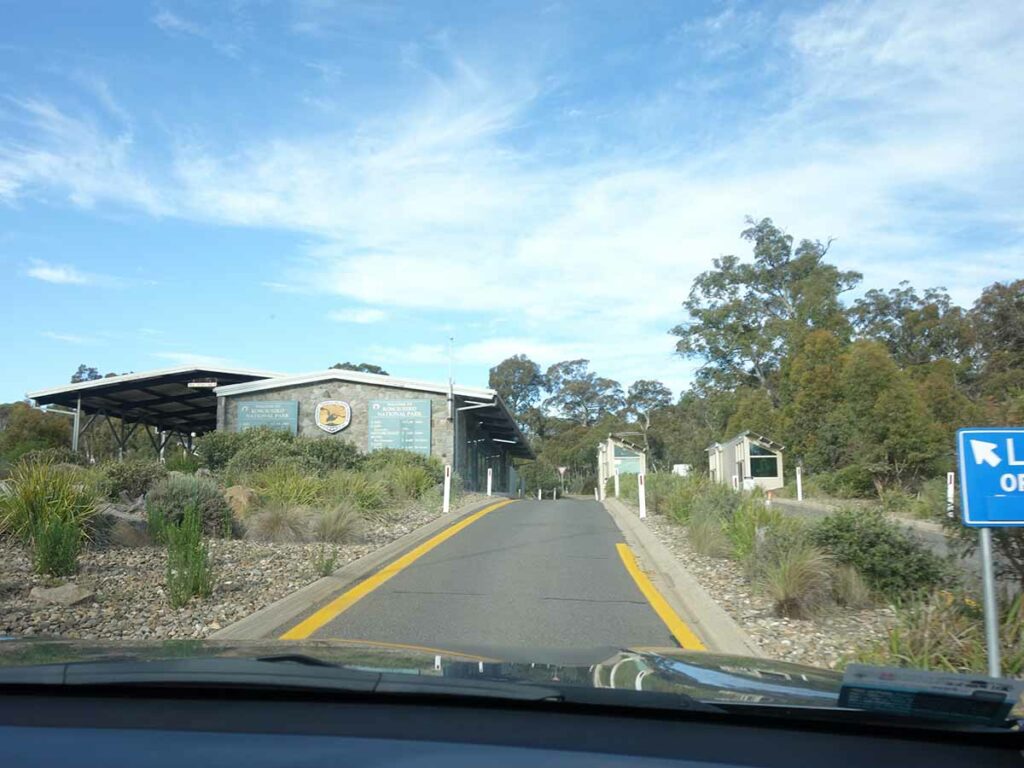
Entering the National Park

Turning off from the main road to the trailhead on the right
Trailhead car park
Things to Know
- Phone: There is limited phone signal on this track, mainly at the high points
- Water: You need to bring your own water. There are few locations to draw water on the trail but if doing so you should filter
- Toilets: There are no toilets at this trailhead with the closest being at the Sawpit Creek Picnic Area located at the Kosciusko Tourist Park shortly after you enter the park
- Dogs: No dogs allowed
- Other:
- The March flies can be ruthless from about mid November-mid March so wear long sleeves and long pants as they aren’t deterred by insect repellent
Disclaimer
This walk was undertaken by the team from Australian Hiker
Last updated
15 April 2026