Mount Sonder NT (15.8 km)
Tjoritja / West MacDonnell National Park
Nearest Town
Alice Springs
Starting Location
Redbank Gorge car park
Finish Location
Redbank Gorge car park
Best Time to Travel
Mid March to mid September
While it is possible to climb Mount Sonder throughout the year you probably don’t want to be doing this walk in summer where the temperatures can reach 40°+ celsius and the trail is very exposed to the sun.
Mount Sonder NT (15.8 km)
Most people tend to assume that Mount Sonder is the Northern Territory’s highest peak however it only ranks number four after Mount Zeal, Mount Edward, and Mount Giles. What it does have going for it is infrastructure as it forms part the the world famous Larapinta Trail so the car park and trail head are easily accessible by car. If you are walking the Larapinta Trail then this walk will either be the culmination of your trip if you are travelling from Alice Springs or the start of a great adventure if you are walking back to Alice Springs. Alternatively you may just doing this walk as you pass through the Northern Territory.
Once you turn off Namatjira Drive you will pass through the camper van car park so keep on driving and you will reach the trail head to walk to either Redbank Gorge or to Mount Sonder. There are basic toilet facilities here along with a picnic shelter and tables if you are just stopping for a break. Have a read of the trail head signs before heading of to Mount Sonder by following the blue Larapinta Trail markers. If you need it there is a water tank just after you start your walk at the campsite. Please make sure that if you use this resource that you turn the tap off properly as this is the water supply for those heading back to Alice Springs via the Larapinta Trail.
Be warned that this walk is pretty well up hill for most of the way and once you get past the first section of the trail and the views to the valley below appear, then you are very exposed to both sun and wind. The trail is well marked but like the rest of the Larapinta Trail and apart from a very small section where you cross over the dry river bed the trail consists of red rocky soil (more rocks than soil).
Many walkers who are doing the Larapinta Trail will try to summit Mount Sonder to see the sunrise which, depending on the time of the year, may mean a 3 am start. Be warned here that if you are attempting a night ascent you will need a good headlight and luck with the weather. The day after we summited others who tried to do this had to turn back as the gale force winds and total cloud/fog cover prevented them form reaching their desination. From a personal perspective I did this walk during the daytime and found the morning views to Mount Sonder from Hilltop Lookout (see our website front page) are spectacular and not to be missed (this only helps those who are walking the Larapinta Trail).
Once you reach the summit of Mount Sonder take the time to absorb the views to the neighbouring peaks and valleys below and use this as an opportunity to take some great photos. The walk back down is reasonably easy with no excessively steep sections.

Trail head

Water tank at the camp site. Look right just after you start the walk and before you cross the dry river bed and you will spot this tank

Make sure you take the turnoff to Mount Sonder otherwise you have a long walk ahead of you

A typical example of the trail

Early views to the valley below

If you look closely you can see the trail head in the centre down in the valley below

Panorama shot from the summit of Mount Sonder

Panorama shot from the summit

Tim at the summit of Mount Sonder
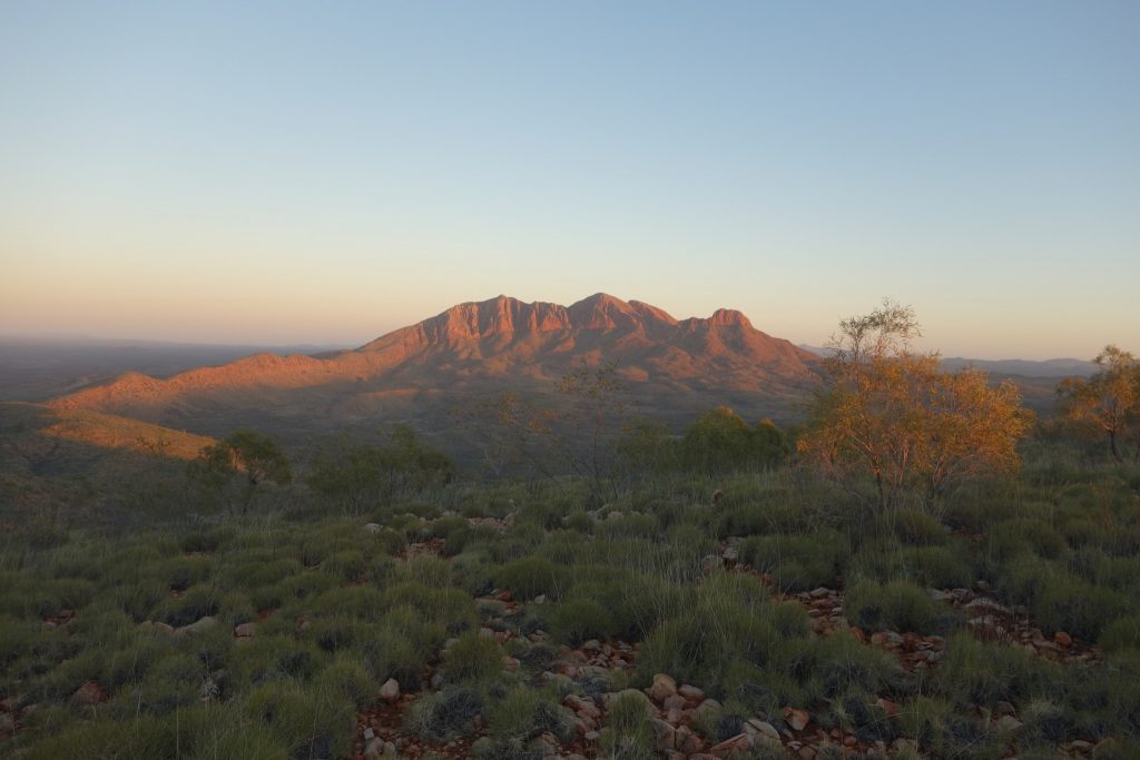
Mount Sonder as viewed from Hilltop Lookout on the Larapinta Trail
Getting There

Google map showing the trip from Alice Springs to Mount Sonder
If you are walking the Larapinta Trail then this is classed as Section 12 of that trip and will take approximately 6-8 hours. This hike is well worth doing provided the weather conditions are on your side (see review below).
Alternatively if you are a day visitor, then Mount Sonder is accessed via Redbank Gorge car park which is 156 km by car west of Alice Springs. The road is sealed and in good condition all the way from Alice Springs but changes to unsealed once you leave the highway. Turn off Namatjira Drive at the Redbank Gorge turnoff
Things to Know
- Phone: The phone coverage is sporadic on this track only being available at the high points on the Telstra network
- Water: Water is readily available during the cooler months in the water tanks at the campsite
- Toilets: Take toilet paper and a trowel with you
- Trail: This trail consists of formed track however there are lots and lots of rocks to get in the way
- Dogs: No Dogs allowed
- Other:
- Many people will choose to summit Mount Sonder at sunrise in winter to view the spectacular landscape below. To do this you will need to start very early in the morning.
- Please note that high winds and/or cloud cover may mean you may not reach the summit or if you do, the views may not be the best so pay attention to the weather
- This hike is almost uphill the entire way. If you are walking the Larapinta Trail set up your tent and drop most of your equipment to make the hike up much easier
- If you don’t hike regularly or are unfit this is a hard walk so allow plenty of time and ensure you have food and water
- Bring wet weather gear just in case
- In mid winter the temperatures can range between -4° Celsius up to around 32° Celsius so come prepared with the right layering system
- Many people will choose to summit Mount Sonder at sunrise in winter to view the spectacular landscape below. To do this you will need to start very early in the morning.
Disclaimer
This walk was undertaken by the team from Australian Hiker