Little Black Mountain Trail ACT (5.2km)
Canberra Nature Reserve
Nearest Town
The closest suburb to the trailhead is Aranda, ACT
Starting Location
Trailhead car park along Belconnen Way (base of Black Mountain), ACT

Finish Location
Trailhead car park along Belconnen Way (base of Black Mountain), ACT. This car park will cope with up to 13 cars
Best Time of the Year to Walk
Year round. Avoid morning and afternoon peak hours to allow for easy car park access
Little Black Mountain Trail Review
This is another one of those trails I had avoided for many years dismissing it as not being ‘worthy’ of my time as it wasn’t a ‘real hike’ but finally I decided to give it a try. I’ll start with the negatives first and really there are only two. First up the car park for the trailhead is located along Belconnen Way which is a busy dual carriage road at the best of times but try and access it during peak hour and you will struggle to slow down for the turn off. You may also struggle to get back out of the car park at the end of the day with people returning home. The second negative is that Black Mountain is a spider web of trails and if you are new to this area it can be hard to tell which particular trail you are on. To remedy this I would suggest you download the paper map on the Friends of Black Mountain website but even then, there may be some doubt about whether you’re on the correct trail at times (as at 26 March 2023 the friends website is under redevelopment).
Start the walk by going through the access gate and heading up the trail until you come to a sign that says ‘Link Trail’ which is about 100 metres in. At this point turn left and there is an information kiosk which provides some more detailed information on the Black Mountain Reserve. Follow the link ‘street signs’ that appear at the various intersections and you will eventually hit the Callistris Trail and at this stage, turn left. Shortly after you will come across signage for the Little Black Mountain Trail and at this stage you can either go straight ahead and go clockwise around ‘Little Black Mountain’ or turn right which is what I did, to go anticlockwise.
As you head up the hill you again turn left after a short distance and you will have a raised hill on the left hand side which is part of greater Black Mountain and the main destination of this walk. There is a well worn option to go up and over this hill but its not a formally marked trail but is obvious. Keep looping to the left as the opportunity presents itself and you will make your way around the hill and come back to the turn point on the Callitris Trail that will take you back to the trailhead the way you came.
Wildlife is limited on this trail at least when I did it but the bird life was pretty good. In addition the woodland provides lots of opportunities for photographing bark if that’s what you are into. This trail also provides good opportunities for views to the Black Mountain Tower on the summit of Black Mountain which dominates the centre of the city, views down to the Parliamentary Triangle, views to the city and views to northern Canberra. While this 5.2 km trail undulates there are no really steep uphill or downhill sections so if you can cope with the distance, it’s a great 1.5 hour walk. Now having finally walked it, it’s well worth a visit.

Entering through the gate to start the walk

This is a dog free trail

Trailhead signage not far from the gate

The trail system on Black Mountain is a real spider web that can be confusing if you don’t pay attention

Head up the hill

Approaching the Link Track. The turnoff is just visible on the left of the trail

Link trail sign turn left here. If you go straight ahead you are on the Orchid Trail which is another option from this trailhead

Information kiosk just in from the turn

Trail example

Bushland example on the trail


This walk is definitely for lovers of tree bark

Veer left on the Callitris Trail

Turn right and follow the signage up the short hill

Feed me! Yet another magpie that expected to be fed

The Canberra Centenary Trail weaves itself around Black Mountain

Turn left

Black Mountain Tower in the distance on the summit of Black Mountain

Optional trail that takes you over ‘Little Black Mountain’

View to Black Mountain Tower

View the centre of the city

View to northern Canberra
Video taken about half way round this trail

Currawong

You can either complete the loop the way you came or veer off on this unmarked trail. This option will save a couple of hundred metres

Back to the trail kiosk and turn right

Head home

Back to the trailhead car park

Back on to the road. You can only turn left here as the road is one way
Getting There

The main trailhead car park is along the base of Black Mountain on Belconnen Way. To use this car park you will need to travel from the city along Belconnen Way. This trailhead is around 5 km from the Canberra GPO and around a 5 minute drive. Be careful otherwise you will drive past the entry
Things to know
- Phone: There is good phone signal on this track on all networks
- Water: You need to bring your own water
- Toilets: There are toilets at the summit if the tower is open
- Trail: This walk is on formed trail
- Dogs: No dogs allowed
- Camping: Camping not allowed
- Track: This trail is on formed track
- Other:
- It’s worth taking a copy of the paper map (unavailable as at 26 March 2023- website being redeveloped) to help with the navigation. Once you’ve done it once it’s actually pretty easy
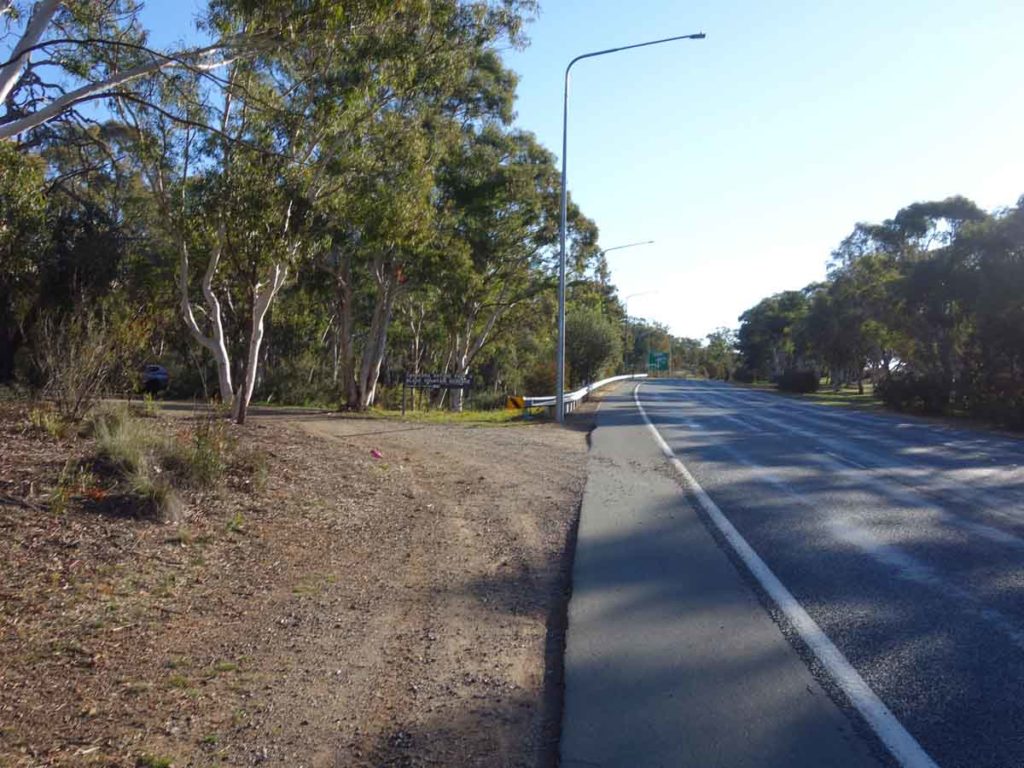
Turn off into the car park. You will need to turn off Belconnen Way heading towards Belconnen Town Centre to use this car park. Avoid accessing this car park during peak hour

Car park signage at the entrance to the car park
This car park will comfortably fit around 13 cars if everyone parks straight

Elevation profile Little Black Mountain Trail. The elevation change isn’t as bad as it looks
Disclaimer
This walk was undertaken by the team from Australian Hiker