Great South West Walk VIC/SA (262km)
A Loop Walk
The Great South West Walk (GSWW) is a 250km-262km walking trail located in the south west corner of Victoria, Australia. The actual distance you walk will depend on your choice of detours. Something that you may otherwise be unaware of is that this trail strays into South Australia for a distance of around 4km as it follows the Glenelg River before arriving at the half way point of Nelson where many hikers will take a rest day. The first 200km of the GSWW was created by Portland High School staff, students, and their families on public land in 1980-1982. The Friends of the GSWW was formed in 1983, before the trail was expanded to a 262km circuit. This trail is managed and maintained by a dedicated group of volunteers and in talking to a number of locals in the Portland and Nelson, the trail is well known and supported by the local community.
For those living in Victoria and South Australia this is a well known track but in my case I only came across it a couple of years ago. At that time I decided that the length and elevation change of the track suited both my requirements for a walk as well as my love of ocean hiking.
Starting and finishing location
This is a loop walk with the main trailhead being in Portland at the Visitor Centre, Portland, Victoria. You could also start and finish in Nelson if you wish


Trailhead signage outside Visitor Centre along with information signage
Best time to travel the Great South West Walk
Year round
- Being a walk that is half inland and half coastal this trail has very different weather patterns across its length
- The coastal walk of this trail is very different to inland trails. The environment on the Great South West Walk is impacted by the Southern Ocean which brings lots of rain and winds. This part of the Victorian coastline can receive around 840 mm rain annually
Summertime daytime averages (January)
- Mean Maximum 22.3°C
- Mean Minimum 12.5°C
- Rain days average 5.3 days
Wintertime daytime averages (July)
- Maximum 13.2°C
- Minimum 6.3°C
- Rain days average 17.6 days
The time of your hike will impact your reasons for doing this trail. Here are some things to consider:
- If you want a bit of solitude avoid school, Christmas, and Easter holidays
- If you want to see whales look at hiking late July to late August
- If you want wildflowers look at November
- If you don’t like the heat avoid November to March as the temperatures can get quite hot compared to the seasonal averages
- If you don’t like the rain skip May to September (July is the wettest month of the year)
Map
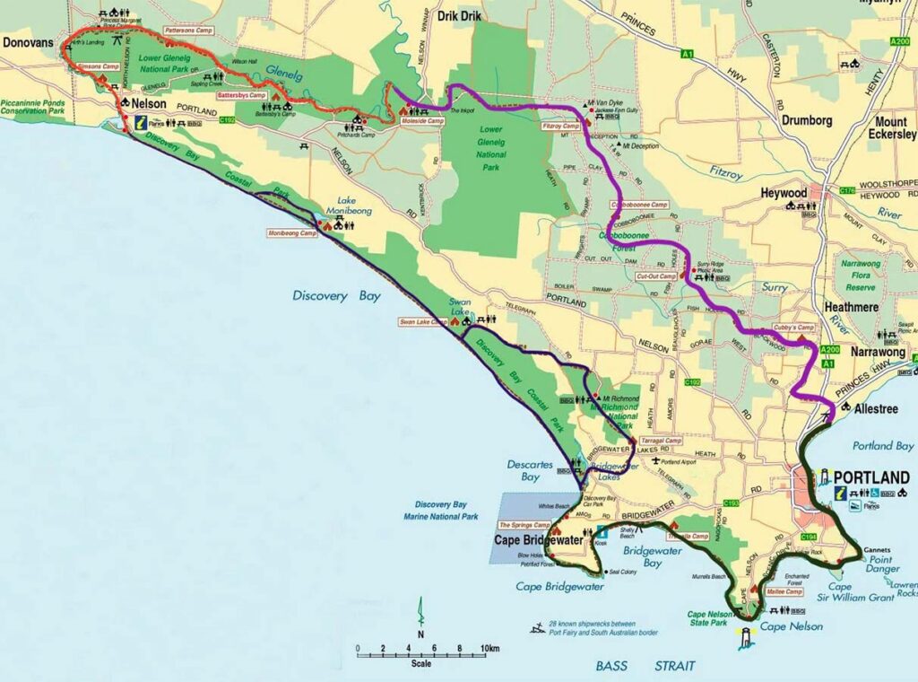
Trail image for the GSWW map, Victoria – 250-262km in total
- Map from the Great South West Walk website
Nearest Town
- Portland Victoria – main trailhead
- Nelson Victoria – optional trailhead
Trip Podcasts
If you want some additional information have a listen to the series of podcasts on this trip:
- Australian Hiker Podcast Episode 344 Great South West Walk Expectations
- Australian Hiker Podcast Episode 345 Great South West Walk week one on trail
- Australian Hiker Podcast Episode 346 Great South West Walk week two on trail
- Australian Hiker Podcast Episode 347 Expectations versus Reality (due for release late on the 12 May 2026)
My Trip
Given the choice I prefer to do my hikes in the cooler months of the year because it’s much easier to warm up than it is to avoid the heat. This will often mean more rainfall but I can cope with that. We originally planned to do this walk in late March but in looking at the maximum temperatures I decided that it was too warm and pushed the trip back a month. From talking with a number of hikers, this was the right decision as although I had some hot days, I certainly had no rain whereas March was a wet month this year.
The following write up will take you through this trip day by day. It includes suggestions based on my experience on how to get the best from this adventure if you choose to undertake this great walk. In addition, we have released a series of four related podcast episodes (see links above/below) that provide an alternative way of finding out more about this trail.
A slide show of this walk has also been included below that contains many more images and videos that we couldn’t possibly include in this write up.
My Itinerary
Measured distances for each day
- Day 1 Portland to Cubby’s Campground (20.2km)
- Day 2 Cubby’s Campground to Cut Out Campground(15km)
- Day 3 Cut Out Campground to Fitzroy Campground (22.9km)
- Day 4 Fitzroy Campground to Moleside Campground (21.6km)
- Day 5 Moleside Campground to Battersby Campground (19.4km)
- Day 6 Battersby Campground to Pattersons Campground (13.4km)
- Day 7 Pattersons Campground to Nelson – Casuarina Cabins (20.9km)
- Day 8 REST DAY
- Day 9 Nelson to Monibeong Campground (22.6km)
- Day 10 Monibeong Campground to Swan Lake Campground (17km)
- Day 11 Swan Lake Campground to Springs Campsite (23.3km)
- Day 12 Springs Campsite to Trewalla Campsite (17.1km)
- Day 13 Trewalla Campsite to Mallee Campsite (15.3km)
- Day 14 Mallee Campsite to Portland (22.2km)
Total distance walked 255km (including detours)
The Lead Up
My original plan was to do the 164km grampians peak trail, also located in Victoria but given this was going to be my first long distance hike post my 2025 hip replacement I wanted a trail that although longer wasn’t classed as challenging due to elevation change. Strange as it may seem I ended up choosing the 262km GSWW even though it was roughly 100km longer but this trail isn’t big on elevation change and scrambling.
If I’m only doing one long walk a year like I have in the past, my target window is usually somewhere between July-September to avoid the heat. Given I am now doing Australian Hiker full-time, I’m planning three long hikes a year and as I already had the Heysen Trail tentatively booked in for later this year, providing this walk went well, I really only had Autumn available to me.
Most of my walks tend to be ‘end to end’ starting at one location and walking to another location often more than 100+km away. The GSWW is one of those rare walks that is actually a loop. Initially Gill was going to accompany me on this walk but due to the Middle East fuel crisis we had to make some assumptions about where it was heading and what the availability of diesel fuel was and Gill ended up pulling the pin on this hike as she didn’t have any flexibility on her return to work. So instead of driving down to Victoria and back to Canberra, I did the sums and decided that as a solo hiker, public transport was the way to go.
As part of the planning process I also had to make some assumptions about my fitness and planned to take the inland alternate route on the southern section of the trail and as part of that to do a combined day of just on 30km. Worse case I could revert to the coastal route if I needed to and save a day so I was willing to ‘wing it’ as I went. Having said that we always keep a day up our sleeves just in case there was a delay on-trail for any reason. Once I had determined my trip itinerary, I booked my campsites which is essential if you are doing trips in Victoria as wild camping isn’t allowed in most areas.
Travel to Portland
My travel to Portland involved getting a 4:00am bus from Canberra to Southern Cross Station in Melbourne. By the time I arrived in Melbourne and then caught the train and busses to Portland, I arrived at 7:00pm after 15 hours of travel.
If we had traveled down by car we would have started walking the next day but after a long stint on public transport I decided a rest day in Portland was a good move. In addition to catching up on some rest it was a good opportunity to look around a town I hadn’t been to before.

Public transport in Victoria traveling to to and from the trailhead was relatively cheap

Quality Hotel in Portland, about 250 metres to the trailhead
Day 1 Portland to Cubby’s Campground (20.2km)
- Start time: 7:27am
- Finish time: 2:46am
- Distance: 20.2km
Another good night sleep to help set me up for the start of this trip. I made sure when I purchased my dinner from the nearby supermarket I had enough left over for breakfast so I didn’t need to go to a cafe. This also allowed me to leave the hotel and walk the 3250 metres to the trailhead.
Last night when I was doing the final packing and preparation I noticed that the weather forecast was for up to 3mm of rain so I expected to be starting this walk in the rain. I didn’t get to see what the weather was doing until I got downstairs and now up to 4mm of rain during the morning is forecast. Based on this I expect to be putting up my tent in dry weather. As it urned out apart from a very short shower in the morning and a couple of showers overnight, the rain was not an issue.
Today I will be walking just over 20km with my destination being the first campsite on the trail, Cubby’s Camp with the first 90 minutes spent making my way out of Portland through the outlying semi-urban areas before turning left at the Henety Bay Beachfront Holiday Park. Sure enough when I reach the supposed turn, the turn mark and sign was obvious but you do need to pay attention to make sure you don’t miss this turn. From here it was across the road and then up a shared access road, over the stile and then I was into the first bushland area. I spent the rest of the day walking through rural areas before reaching the first of the real bushland after lunch.
This trail is marked by red arrows and shortly before lunch I questioned my direction (needlessly) because after leaving the reserve and turning left as directed by an arrow, I expected to have a confirmation arrow around 20-30 metres down the road. As it urned out I was on track and then made my way around the main road. I ate launch at the Bolwarra Hall which timing wise worked well given there were a couple of easily accessible picnic benches. From there I continued on with the bushland slowly taking over. I would say here that this day was more about ‘getting bush’.
Cubby’s Campsite is typical for this trail consisting of a two sided shelter to prepare meals and socialise with a water tank attached. The shelter had timber benches on the two covered sides along with what was usually a rectangular table. A designated fire pit, a composting toilet with toilet paper, another water tank, and two picnic tables although most campsites only had one. The ground at this site was bare earth and would likely get messy in heavy rains.
Apart from three teenagers who turned up on horses, I discovered I was alone at the shelter and this was the case until late in the trip when I shared the last few campsites with there other hikers.
Throughout the day I didn’t see or hear much in the way of wildlife but the nighttime activity was one of the heaviest for the whole trip with various birds, possums, and wallabies vocalising throughout the night and coming quite close to my tent on a number of occasions. At around 5:30am in the morning I heard a huge crack followed by a tree fall but when I got up not long after, I couldn’t see the tree.

Tim at the GSWW trailhead

Along the coast and up the stairs

Portland Lighthouse

Follow the red trail marker

Turn left at the holiday park

Along the access road

Lunchtime stop at the Bolwarra Public Hall

Along the railway tracks

Through the bushland

Cubby’s Campground shelter and water tank

Cubby’s Campground shelter and picnic table

Cubby’s Campground toilet and water tank

Inside the toilet facility, basic but functional. Toilet paper was provided but we still recommend taking spare toilet paper with you as some of the toilets had none

Hiker registration book. FILL THIS OUT as it assists the trail organisation and is a safety tool for you
Day 2 Cubby’s Campground to Cut Out Campground(15km-19km)
- Start time: 8:30am
- Finish time: 3:26am
- Distance: 19 km
Late start by my standards and by the time I finish my social media post and start hiking the 15km to Cut Out Camp, it was after 8:30am.
Good day yesterday but I realised that it was the longest day post my operation I had done and also with the heaviest pack I have carried for a couple of years. I’m physically tired but the body held up well. Today was spent walking through reasonably heavy forest for most of the day with short sections of management road in between. While I knew I had a detour due to a tree fall that had destroyed a bridge for some reason, I didn’t associate it with today’s walk so when it came time to crossover, the trail was taped off with a number of signs directing to a detour on management road. In itself this wasn’t a problem but my GPS came out at around 19km which was an addition of 4km. That wasn’t a bad thing but the forestry service was redoing the roads and it was very hard-packed which was hard on the body.
Cut Out Camp felt a bit more rustic and with grassy cover rather than bare soil. After last night’s tree fall I was very careful to look up and avoid dead branches which was actually quite hard. The layout was very much the same as at Cubby’s.
What should have been an easy day ended up being physically very demanding and when I did eventually go to bed at 6:12pm, it was a hot night that meant most my new summer weight sleeping bag was just a quilt. As was the case the previous night, I had lots of visitors throughout the night including a heavy breather that came to check me out! When I got up in the morning there was a wallaby and an older joey hanging around, as well as a larger male on the other side of the camp.

Forest walking

Fungi on the trail

Messamate Forest

More forest

Detour

Hard packed road for the detour, it was like concrete

Campsite entry for walkers with the detour in place

Cut Out Camp shelter

Cut Out Campground
Day 3 Cut Out Campground to Fitzroy Campground (22.9km)
- Start time: 7:30am
- Finish time: 4:00am
- Distance: 22.9 km
Another day of two halves as I made my way to Fitzroy Camp at a distance of 22.9km.
This morning was all about the wildlife. First were 4-5 goats which was a new one for me and very healthy looking ones at that given goats can live on just about anything. Then there was a tiger snake and I don’t know who was more startled. It saw me before I saw it and I only noticed as it moved off given the colouration was prefect for the environment. In addition my sunglasses didn’t help. Then I had wallabies that didn’t seem to care about me whereas they usually disappear as soon as they see someone. And last but not least three large kangaroos bounding over tree trunks across the trail to get out of my way; the afternoon brought nothing in the way of animal life as the temperature heated up.
The other impact of seeing the snake was what caused me to slow down and focus on potential snakes. In addition, the heat was slowing me down as well. As a result I took 8.5 hours to travel my distance.
I ended up running short of water about 500 metres out of camp and then discovered that my water filter had aged-out. Not a problem I thought because I always carry backup tablets but realised I hadn’t checked when I packed. As a result I would be drinking unfiltered water for the rest of the trip so we’ll see what happens there! I do have gastro tablets so I at least I did something right. On the subject of water really the only sources in dry conditions are at camp or when you’re near a river but don’t count on it.
Passed through Cobboboonee Camp at around 11:00am (11km in) and stopped for an early lunch. This campsite was similar to others structure wise but again a soil surface. Fitzroy Camp is again the same structure but narrow and long with a red clay based surface which looks like it would get quite muddy with some rain. Again a typical camp layout but in this case it was surrounded by heavy tree cover so it was more elongated with the toilet being around 40 metres away from the rest of the infrastructure. Campsite options were good and I managed to get a flat site which has been the case with my previous nights as well.
I wrote my posts around 3:40am as I thought I might as well do something given I was wide awake. I will try to get a couple of hours of additional sleep as I finish this post.
One thing to note is that the tree cover is so heavy that my satellite communicator isn’t getting a signal out and my phone signal is also very hit and miss. I definitely couldn’t get internet so my posts could have been delayed. It was a case of standing on one leg with my tongue poked out and phone raised in the air to have any hope of getting a signal. I occasionally managed to get a message out but the heavy tree cover meant it was a struggle.

Off I go for the day in the mist

Trail example

There are goats! Just look in the centre of this image

Fungi

Wallaby on trail

For when its wet

Tree across the trail

Cobboboonee Camp. This campsite is 11km from the start so most people keep on going but its a great place for an early lunch

Cobboboonee Camp fire pit and table

Trail example

Fitzroy Campground
Day 4 Fitzroy Campground to Moleside Campground (21.6km)
- Start:8:03am
- Finish:2:46pm
- Distance: 22.4km
Started the day with a mistake first up. There is a possible detour if there has been heavy rains but I misread the sign and took the detour by mistake which added about 800 metres to the day. I suppose I should use my glasses a bit more!
Today was another day of walking through heavy forest. This is what this north section of the trail is about, the trees! As such the phone signal is again very intermittent but I discovered the new satellite message service that Telstra offers as part of plans provides access to the Starlink network. While it can take a little while it’s possible to send text messages when nothing else will work.
My destination today is the Moleside Campground which is a shard site with the canoe campground and located on the Glenelg River. I will spend the next few days following the river as I make my way towards the town of Nelson. I eventually reached camp in mid afternoon and what a difference compared to previous sites. This campground is immediately adjacent to the canoe campground and as such shares a set of toilets. The hikers site is up a set of steps to maintain some separation.
There are wallabies everywhere chewing on the nice green grass.
Again a typical layout for the campsite but it was harder to find dead flat ground to set up my tent. One thing to note is that because of the adjacent river, the condensation on my tent was very heavy in the morning and the nighttime temperature was low. The nighttime animals were still about and when I got up in the moving all the female wallabies had gone to be replaced by the larger males. During the night there was a possum fight near the shelter followed by a large thud as the loser was pushed off a branch hitting the metal roof. Lots of crickets and frogs throughout the night.

Detour option

Small section of road walking in the detour

Fenced reserve at the top of the hill

Inkpot sign

The Inkpot. I’m guessing this gets its name from the dark colour that looks like ink

Up the steps to the hikers campground

Moleside Campground

My tent at Moleside

Glenelg River
Day 5 Moleside Campground to Battersby Campground (19.4km)
- Start:8:06am
- Finish:2:51pm
- Distance: 19.4km
I tried to get away at 7:30am but by the time I recorded my social media it was just after 8:00am when I left. I say record because both the internet and phone signal were so bad I couldn’t publish so everyone had to wait for the posts as I get closer to Nelson.
I was hoping to see koalas today but as far as on-trail life went all I saw at a distance was some noisy black cockatoos. I couldn’t tell what type they were as they were too far away. (I spoke too soon about not seeing koalas as I just went to the toilet and came back to my tent and there is a koala vocalising at the rear of the shelter.)
When I stopped for a break around 90 minutes into the day even though I felt I was moving well. However, my Garmin GPS was telling me I wasn’t going to get to Battersby Camp until around 3:30-4:00pm based on how much ground I had covered which was a worry as I was walking slower as the day went on.
I had forgotten that when you put a Garmin Inreach into expedition mode to save battery that it drops a pin less frequently and then draws a straight line between each pin. Works really well when you are travelling in a straight line but as I spent much of the day looping around the river bends, the overall distance it indicated I had travelled was shorter. While I was expecting to get to camp at around 4:00pm based on my GPS, I arrived at 2:51pm, taking an average of 21 minutes per kilometre – not too bad given this is my first long distance hike since my hip replacement. My hip is fine, it’s my excess weight and general fitness that is slowing me down at the moment!
At one point I thought I had run out of water with what I thought was about 4km to go. This surprised me as I’m pretty good at judging my bladder water levels even when I can’t see it. When I checked, the bladder hose had kinked and I still had over one litre which was what I thought I would have.
I spent much of today following the Glenelg River and in looking at tomorrow it’s more of the same although the route seems to be a bit straighter. Today was another day spent in the forest as well as taking in the river views. Immediately before lunch ‘something’ shot off from under a bush alongside the trail. It had legs (not a wallaby or kangaroo) and was large but apart from that it moved too quickly to see what it was.
Speaking of the river, when I arrived at the Battersby Campground one of the local schools was there which I had seen yesterday exiting having just spent the day canoeing from the jetty located directly in front of the walk-in camp. After having a cuppa I decided I would head down the short distance to the jetty and dangle my feet in the river. Oh that was nice! My feet really appreciated it although the small crane I startled wasn’t happy and let me know about it on no uncertain terms.
Battersby is a lovely camp and purely because of the jetty and the birdlife, it’s my favourite camp so far and remained so at the end of the trip.
Before I arrived I had a short rest at the main campground not realising my camp was immediately adjacent and watched someone with a serious 4WD trying to reverse park a caravan without success. I was so close to offering to help but opted not to because I thought that might be embarrassing. He gave up and left after more than a few additional attempts.
I spent the rest of the afternoon drying my tent from last night, sorting food, and watching the large group of fairy wrens and other assorted birds catching dinner before heading to bed for my latest night yet.
One thing I haven’t mentioned is when I got to the shelter there was a packet of water purification tablets and a note from one of our followers who read about my filter problem and decided to help out. I can’t say ‘thank you’ enough for this kind gesture, I was a bit overwhelmed at the generosity and can’t thank whoever did this enough. The more hiking I do the more I realise that there are some really special people in the hiking community.
Whoever it was, please flick me an email but if you wish to remain anonymous that is fine too. Just know that you made my day – your gesture was totally unexpected and greatly appreciated!

Off I go again

Trail example

Glenelg River from above

Arriving at Battersby Camp

Battersby Camp shelter, my favourite campground of the whole trip!

Canoe wharf

Aaaaahhh! So good!

Local wildlife. This site is really about the birdlife
Day 6 Battersby Campground to Pattersons Campground (13.4km)
- Start: 8:11am
- Finish: 12:52pm
- Distance: 13.4km
Given I only had 13.4km to travel from Battersby Camp today I set my alarm for 6:40am but still ended starting to pack at 6:20am after a mixed but very good night sleep. I had one period of solid sleep and most of it REM sleep so I am dreaming multiple times a night and having some very weird dreams. At one stage I woke up and it was dead silent, probably due to my snoring scaring off the wild life. It didn’t last long as nature reasserted itself.
Another cold and damp night being located next to a river but still not cold enough to have my arms or head covered by my sleeping bag. After packing up, eating breakfast and recording social media for when I can finally access internet again, I left a few minutes later than the day before.
Today saw me parallel the Glenelg River for much of the day and again through dense forest but you can tell that the vegetation is becoming more coastal. I had lunch at around 11:45am and while I was sitting there a huge flock of black cockatoos flew over. Apparently this is a common sight, particularly near the pine plantations which were just across the river.
As I sit here writing this post I have four koalas vocalising in close proximity grunting at each other.
After arriving at Pattersons as early as I did, I had a hot drink, set up my tent to dry out from last night, and set up my sleeping mat inside the shelter for a rest. At some stage one of the trail volunteers turned up to replace the track log sheets and as you do, we spent time talking about the trail and hiking in general. They also pointed out the blaringly obvious koala sitting in the tree directly in front of the shelter that I had failed to notice. 
This track is maintained mainly by volunteer staff and they do a great job. In addition, every local I have talked with was doing their best to talk up this trail so it’s great to see the community connection.
According to the guidebook, Pattersons Camp is supposed to be the pick of the camps but in my mind it’s Battersby Camp so far and that’s because it has a nice feel and the amazing bird life. Its worth mentioning that water had been released from the irrigation system not long before so there was a dead patch of grass on the river edge which probably coloured my view of this campsite.
When the volunteers left it was time for dinner and this post is the last task before I head to bed.
I am looking forward to having a shower tomorrow night in Nelson, catching up on social media, catching up with Gill. I am also hoping that my snack of choice for the past eight years – a Weiss bar and a Coke No Sugar or Pepsi Max – are available.
I will try to get away early as I can just so I can get to town early (around 2:00pm).

Trail marker

Location marker in case of emergency

Koala at Pattersons Campground
Day 7 Pattersons Campground to Nelson – Casuarina Cabins (20.9km)
- Start 8:01am
- Finish 4:01pm
- Distance: 20.9km (more on this later)
A longer day as I head into Nelson for my rest day. The day started just like the previous day but in this case I am walking along the river cliff tops getting a view of the highest limestone cliff sections of this river. They are pretty impressive and even though I moved from river level up to the top of these cliffs apart from the odd small section, you don’t notice the elevation change. The trail organisation has placed a number of seats along the way at strategic points just to sit and take it all in.
At my morning tea break I decid to see if I had phone/internet signal and boy did I with my phone figuratively blowing up – I typically get about 400 emails a week! I thought I would call Gill and she indicated from the Garmin map that she was following me on, that if I made a short detour I was only around 1km from Nelson. Apparently some people doing this trail discover this as well and just skip this section. It’s an option, it’s your hike, so do your own thing.
At this stage I asked Gill to check out accommodation options for me in Nelson and we ended up choosing Casuarina Cabins – the owner Dave is friendly and the accomodation is comfortable. It also suited my need to hand wash my clothes and hang them on the deck railings to dry. Off I go again!
One comment I would make here is that the guidebook has been very well done and you pretty much know where you are from the succinct descriptions. I strongly suggest you get the map and book package when planning and walking this trail. I’ll do a review of this resource the week after I get off trail.
Close on midday I crossed into South Australia for a distance of 4km and it was really obvious; not just the sign but the landscape changed almost instantly. Along this section of the trail there were a number of what are called huts but for any body else these are not huts and are very lavish!
When I stopped for lunch I decided to spend around 30 minutes catching up on my Instagram posts so another reason for my extended day but I felt very rested when I started up again.
There was no sign I could find to say that I was heading back into Victoria but there was a distinct change in vegetation again and when I got my Garmin Inreach map out, it told me I had just crossed the border. It was at this time I decided to check the weather and discovered why I was struggling today – the temperature had hit 28.5 degrees Celcius. I don’t do well in the heat and this is the main reason I prefer to hike in July-August, rain be dammed. It would explain why I was taking so many breaks. I could have checked this on my Garmin but just didn’t even think about it, duh!
I passed Simon’s Camp which is just out of town and one that many people would bypass for that reason. This campsite provides an opportunity to have a ‘full camping experience’ if you don’t want to have a town stay. The good thing here is that it meant I had around 1km to my chosen accommodation.
Accomodation wise there is so much choice in Nelson and I was happy to ‘wing it.’ However, next weekend an event is on and I would have been camping with everything booked up. Keep this in mind if you are planning this trip.
Now for the down side. While Nelson provides a large array of accommodation it lacks in the food department. The kiosk which is mentioned in the guidebook no longer exists. The locals typically travel the relatively short distance into Mount Gambier for their weekly shop because there is limited choice in Nelson. I ended up walking the round trip of 2.2km to the BP service station (and post office) to get what I was hoping to be a pizza only to be informed that pizzas are off the menu at the moment. I did however manage to get my Weiss Bar (two actually) and Coke No Sugar (1.25 litres) and two crab sticks that were quite nice. I then purchased something for breakfast. I need to head back down and get a frozen pizza for ‘Linner’ and something else to drink but I’ll do that around midday tomorrow.
Theres is an opportunity waiting for someone here for consistent good quality takeaway. Apparently the service station is looking at doing a bigger range of food staples but that hasn’t happened as yet so keep this in mind.
The rest of today was spent doing social media before having my latest night on track going to bed around 9:30pm.

Melaleuca in flower

Glenelg River view

Seat on the trail

Into South Australia

On the trail

Approaching Nelson

Nelson boat ramp

Heading to the accomodation

Accommodation in Nelson
Day 8 REST DAY
Today was a rest day in Nelson and by that I mean I’m not walking but am working. I spent much of the morning catching up on social media before heading down to the BP service station to get food for lunch and dinner. It was also time to sort out my remaining food for the trail which really involved jettisoning things I know I won’t eat. I estimate this dropped around 1.3+kg out of my pack which is always a bonus. My food tastes seem to change between every major trip and there’s no rhyme or reason as to why; I just seem to go through phases.
The rest of the day and into the evening was taken up with the podcast and making some changes to my accomodation, more on this later this week. My latest night of the trip so far.
Tomorrow I head off on the southern beach leg of the journey which will have me heading back towards Portland and the trail end this Saturday.

The BP service station is the place to buy food, both cooked or otherwise. Its also the local post office for food drops
Day 9 Nelson to Monibeong Campground (22.6km)
- Start 7:27am
- Finish 3:25pm
- Distance: 22.6km
It makes for an easy start when you don’t have to pack up all your camping gear at the start of the morning so I left my cabin at 7:27am. It took me until 8:39am to walk from Casuarina Cabins at the top the town, through the town itself, along the beach access road and onto the beach. After doing some social media recording I was off.
At one point I realised that someone was walking behind me and it turned out to be a section hiker from Melbourne who was doing a piece of the trail and was returning to Monibeong Camp to collect his car and then head back home. This trail provides great opportunities to do section walks.
He eventually powered ahead and I continued on at a more leisurely pace, taking photos as I went. On the whole, the beach walking was relatively easy with rare exceptions of having to avoid the water on an incoming tide. I did notice that there was a track at the top of the dune that would have been a harder option but necessary when the weather was rough and driving the sea onshore.
At one stage the signage directed me inland to avoid some dodgy rocky crossings that were occasionally underwater but the inland option was very hard to work out due to the overgrown track that needs a bit of TLC and some extra markers. After spending some time reading the guidebook I worked out where I was going. I did come across some aboriginal middens along the way though.
After a time I was back down on the beach after passing Noble Rocks. It was at this point I decided on a lunch break. For me the ocean is my happy place and combined with hiking, it doesn’t get much better so I just lay on my pack against some sloping sand and watched, listened to and smelt the ocean….aaahhh life is good!
Once I started up again I walked past the inland alternative route but as much as the guidebook says that this inland section is more interesting, I prefer the ocean so kept walking along the beach. With the occasional need to avoid the incoming tide I was walking on firm sand the whole way.
I got concerned at one stage that I may have gone past my turn off but in checking the guidebook, I realised I was still on-track. When I got to the turn, the landscape was very obvious as was the sign.
From here it was about a 1km walk on a sandy trail inland to Mombeong Camp (that’s the spelling on the shelter). Today took me just on eight hours due to confusion on the inland sections of this trail as well as me just taking in the view.
This camp site felt a bit weird at first and I realised that there were no eucalyptus trees that have been my companions at every other campground, it’s mainly wattles here. The ground is also very sloped and while there are some good tent sites if there is a large group, you’d want to claim your site quickly or else get used to sleeping on a slope.
Apparently Lake Monibeong is only 200 metres away but I was so tired I didn’t take the opportunity to for a visit.
I set up my tent and had dinner and by this time the sun was going down. After doing this post and a podcast recording it was time for bed. I realised through the night that I am almost exclusively in REM sleep throughout the entire night on this trip and I am having some very weird dreams.

The hotel in Nelson is located at the bottom of the town

Heading out of town

Heading to the beach

Wallaby just off the trail

Down onto the beach

Shipwreck rock

Trail marker highlighted by sea rubbish

Trail marker

Monibeong Campground
Day 10 Monibeong Campground to Swan Lake Campground (17km)
- Start: 8:39am
- Finish: 3:36pm
- Distance: 17km
Today was another day spent on sand but this time the high tide was earlier and higher in addition to the beach being higher in some areas which meant a more rapid water rise.
In trying to walk on firm sand it meant that I was at risk of getting wet feet as the water rushed in, even when I was 20-30 metres away from the water. I had one instant where I had to jump up onto a 1 metre sand bank otherwise would have been wet to the knees. Another time I was looking at what was coming up and had to cut inland on the dunes as I would have gotten very wet. From where I cut down back onto the trail, this was obviously a popular option.
Today was also a much slower day due to the softer sand so all up with my stop and smell the roses approach and the softer sand, it took me eight hours to cover the 16.5km. Tomorrow the sand is supposed to be soft again and I have 22.5km to cover so it will be a long day and I’m going to start earlier and push a bit harder.
Lots of birdlife again throughout the day of various types but no other wildlife.
My destination point was the Swan Lake Campsite and I needed to find the very obvious break in the sand which is where vehicles access and it took ages. This takes me through what is supposedly Victoria’s biggest sand dunes and if you do a Google Earth search of the Swan Lake Camp you’ll believe it. I had a 1.9km walk into the camp itself which is wonderful if you are taking the inland alternative the next day because you continue on from the camp. However, I will need to walk back through all this sand before I get to the beach again to continue on up the coast.
The campsite itself is typical of what I have seen so far but the vegetation is a bit dryer.
Another good night sleep and not as cold and not as much condensation.

Beach rubbish

Along the beach

Vehicles on the beach aren’t allowed. These track are going through the nesting zones for the Hooded Plovers

Swan Lake Campsite

Swan Lake shelter
Day 11 Swan Lake Campground to Springs Campsite (23.3km)
- Start: 8:00am
- Finish: 5:45pm
- Distance 23km
Today was the last of my beach days and boy was it a hard one, and long! The guidebook says that this is a quicker option but don’t believe it. The difficulty is very dependent on the weather/sea conditions and while I had less impact than yesterday because of incoming tides, the sand was marginally softer and it was slow going. Part of the reason for the trip duration was me doing social media. Once I hit the beach, I spent about 30 minutes posting before heading off, not something the typical hiker has to deal with.
Today was again dominated by birds on the beach including plovers, oyster catchers, and various gull species. I did also see a couple of hooded plover chicks and from doing some reading and the ever present signage I learned these birds are the pandas of the bird world with only a 2% success rate with breeding. I did also see a black wallaby once I turned inland.
The turnoff inland was almost right at the end of the beach before the bay wraps to the right on a very steep section of sand. I must admit to a false start that also cost me some time here.
The turn off from the beach is not vertical but it is steep. I found that using my poles to help drag me up and with using a previous hiker’s footsteps did help but it was slow going. There was also a piece of rope hanging down but by the time you get there you were almost at a plateau. Note I didn’t say top here because there was another easier short ascent immediately after.
I should mention here that this coastline is espoused to the Southern Ocean and normal high tides come very close to the dune lines. You can see the impact that the storms have on these areas with large sand dunes impact regularly and even washed away.
Now for the bad news! After achieving the summit which does provide good views to the ocean and to the nearby caves you then have to descend an equally steep section of sand to the pathway below. It’s easier but I know a lot of hikers don’t like descents like this including me.
From there you are back onto normal coastal bushland trail as you weave your way towards your destination. Not long after exiting the beach you will reach a crossroads that directs you to your chosen destination and in my case Springs Camp another 6.5km on! The remainder of this walk takes you past a wind farm and initially through lower elevations dominated by wattle in a sandy but firm footpath.
You eventually ascend to the cliff top that provides scenic views of the ocean and beach below. In this upper section you will pass petrified trees. This upper section goes up and down and if you are energetic and it’s warm enough, there is even a route down to a very nice looking beach.
I arrived at Springs Camp before dark and was greeted by three other hikers I have been following. They chose the inland route which I was originally going to do but because I opted for the coastal route, it allowed me to catch up. This will means three nights of shared camping.
The Springs Campsite is very much on the end of the headland that you have been approaching all day and it’s tucked into a small gully that provides protection from the ocean winds although you can still hear the waves.
This campsite is typical of the others on this trail but for some reason the table in the shelter is square, not rectangular, and is also too far away from the benches to comfortably eat. Someone was obviously testing a new design out and didn’t get it quite right! The campsite is well surfaced with grass and being away from any water bodies was nice and warm compared to the previous nights and with minimal condensation on the tent.
Supposedly we have a cafe on-trail tomorrow and given I have been thinking about food more than I usually do, I am looking forward to a non-camping meal. You will hear the scream if they aren’t open!

Heading back out to the beach

Almost there

Be careful laying on the beach. These ants will find you and they are bigger than they look in this image

Birds in flight

Information signage is targeted on this trail

Local plant life

Birds in flight
Day 12 Springs Campsite to Trewalla Campsite (17.1km)
- Start: 8:21am
- Finish: 3:14pm
- Distance: 17km
Today was a shortish day with the guidebook saying 17km but the sign at Springs Camp saying less. In these cases I always work on the longer distance. I had a fairly late start this morning because I got into camp later than I hoped last night. The other hikers had gone to bed not long after I arrived so I didn’t follow my usual routine not wanting to disturb them and needed to play catch up this morning.
Today I was focused on getting to the Bridgewater Cafe for lunch. To get there I spent much of the morning walking along the cliff tops, getting views down to seal colonies, and learning about some amazing geological history of the area through the interpretive signage.
I have spent a lot of time both in a boat, on land, and in the water around seal colonies so it’s not a big deal to me. Even so, the best opportunity wasn’t from the main viewing platform but rather as I approached Bridgewater – I watched a large group of pups playing ‘chasey’ in the water. So much joy in their play.
I reached the Bridgewater Cafe at just on midday and departed after a very pleasant lunch consisting of a Cajun Spiced Salad which I would happily eat again. Being one hour in duration this was a long lunch for me but a chance to take advantage of the shorter day. It may sound strange to focus so much on food but after two weeks of eating hiking food and losing weight along the way (I lost 5.4kg on this trip), when I’m not thinking about hiking, I’m thinking about food.
After lunch it was another walk down the beach but this time it was a much less violent affair along a very wide and relatively calm body of water compared to the last few days.
The turn off the beach was obvious and one of the key things to keep an eye on is in looking for the trail markers but also keeping an eye on what’s coming up. If it looks like you can’t get around a headland due to the water then expect a turnoff. If there is no turnoff look for inland alternatives like I had to over the last few days.
Once I turned inland it was a matter of walking through the coastal bushland on an easy but undulating trail before arriving at Trawalla Campground.
This is a very similar campground compared to Springs, square table included! Where it was different was that the ground was very uneven and even with only three tents, it was a struggle to find a flat surface. This was a fairly sheltered location and also warm so I opted to take advantage and wash my shirt which didn’t smell that great. I was tired again today so nodded off to sleep fairly quickly which is why I’m writing this in the middle of the night.
One more sleep to go, two more hiking days to go!
One conversation I had with my fellow hikers was on snakes and as a single and a couple, the others had four snake encounters so far where my tally is just one. Given that I’m at the back of the pack maybe they’re shooing them away for me!

Sunrise at Springs Campground

Lookout on the cliff line

Looking down towards the ocean

Windfarm

Petrified forest

Out to sea

Trewalla Campground. Finding flat ground was almost impossible

Tent at Trewalla Campground
Day 13 Trewalla Campsite to Mallee Campsite (15.3km)
- Start: 7:56 am
- Finish: 2:31 pm
- Distance: 15km
Second last day on-trail and according to the guidebook ‘perhaps the easiest day on the GSWW…’ general consensus of the four people travelling today was NOT! Don’t get me wrong this is a short day at 15km but it wasn’t easy.
The walk down to beach was easy and once reaching the beach I stripped off my rain jacket because I was starting to overheat.
The beach walk itself wasn’t a problem but with the incoming tide, the highest of the week, but also the latest, there was the occasional short run to keep my feet dry.
The guidebook talks about the marker post for the trail turnoff but it’s long gone. I had three people ahead of me and they managed to correctly identify an opening in the dune with some rubbish but no marker. This is a brutal part of coastline with hide tides often reaching, and decaying the dunes so it’s no wonder theses markers disappear.
Off the beach I go. Up, and up, and up, until I reach the top of the cliffs. I had already taken a break at this stage only to discover a seat at the top. Great views but the hardest slog of the day.
From here the walk consisted of cliff top walking on the whole with the occasional walk through undulating bushland. Some of the cliff walking came right to the edge of the cliff line and while not a direct drop off, but rather a steep slope following cliff, if you have a fear of heights then beware particularly on days like this one with strong offshore winds blowing.
The first anticipated stop was at the lighthouse and not so much for the tourism aspect but rather the cafe. Today’s hikers were all on a mission to get there but discovered that the current management has extended the opening hours from what’s in the guidebook. It’s worth phoning ahead to double check on the hours.
The food and drinks were much needed and my stop amounted to 70 minutes but given I only had another 30 minutes to go to reach Mallee Camp, I wasn’t in a hurry.
The last section of the trail was very well groomed as it also catered for day tourists as well as thru’ hikers. I had couple of twenty somethings call me ‘sir’ which made me feel old. I’m used to that in Canberra as I am near the military area and have that ‘look’ that means all the cadets play it safe and call me sir.
I reached camp and found my fellow travellers already set up and settled in. This campsite was as far as the shelter went, back to normal with a rectangular table (but this one is much better). The main difference was the tent pads which were essentially sand boxes with shade cloth topping. Nice flat surface but it requires you to get creative with pegging to minimise any damage to the surface.
Supposedly there is an issue here at this campsite with possums but I’m guessing this was from inexperienced hiker who left food in the shelter overnight. A rookie error and one you will only make once or twice.
So was this the easiest day of the trip? Short answer, no it wasn’t. I’ve had easier days in the northern section of the trail. It was however a good day!

Heading off for the day

Warning sign around whale carcasses

Heading down to the beach

Two hikers on the beach

Lighthouse

Cafe near the lighthouse and only 30 minutes away from Mallee Camp

Cafe opening hours. You will see varying times advertised so its worth checking before you start you hike

Mallee Campsite

Shelter at Mallee Campsite
Day 14 Mallee Campsite to Portland (22.2km)
- Start:7:31am
- Finish:2:31am
- Distance: 22.3km
Last day on the trail! Today was one of the longer days on-trail but overall not the hardest. After a good night sleep and a weird combination of wind turbine noise and ocean waves, I packed up early and left camp just on 7:30am. This is my preferred time and after saying goodbye to my fellow campers, at least until they caught up with me again, I headed off.
Not unexpectedly the trail closest to the start and finish of walk is usually the best as they also tend to cater for local walking needs. Overall this was a flat and well formed trail at least until I hit the enchanted forest section about 90 minutes in. This section dropped down from the top of the cliff and went through and darkened forest area that gives it its name. This did really slow down the pace but would be an excellent opportunity to take a break at anytime, particularly in the hot weather. But what comes down must also go up and up, and the steps out were a bugger.
I continued mainly on top of the cliff line with the wind slowly starting to pick up. At this stage the rain forecast for later in the day hit but by the time I stopped and put my rain jacket on it ceased, twice!
Past the quarry, the aluminium smelter, the sewerage farm and the wind farm but in most cases in bushland so it wasn’t too intrusive. I did however learn not to stand underneath a wind turbine and watch the blades spin as my poor little brain couldn’t cope with the contradiction of movements and it made me feel queasy.
I was making good pace for my fitness at the moment and felt like I was moving well, but still have a way to go in preparation for the Heysen Trail later this year.
I had two animal encounters today. The first was another tiger snake stretched out on the trail sunning itself and thankfully I saw it in advance but not quickly enough to get the camera out and get a photo.
My second interaction was closer to Portland with an echidna trundling down the trail towards me. I did manage to get a video this time before it headed into the bush.
As expected bushland gave way to town as I moved my way into Portland proper past the commercial port area and finally I hit the trailhead at the Information Centre. Done and dusted.
This was a great trip and my first long distance hike post hip replacement so I am very happy with how I held up.
And the planning commences for the next hike!

Trail start for the day

Seat on-trail

Windfarm

Heading to the enchanted forest

On-trail

On-trail

Back into Portland

Almost back to the trailhead

And done!
Flora, fauna and the broader environment
- A good wildlife trip overall
- Lots of birds
- One echidna
- Two tiger snakes
- Wallabies
- Koalas
- One seen, many heard
- Not the prime time for wildflower but enough to keep me happy
Final thoughts
This walk is an easy loop walk that includes inland and coastal sections. At around 262km its not going to be for everyone but you can choose to do half the walk and if that’s the case do the inland section.
This trail is still one that isn’t as well known as many others outside of Victoria and South Australia, and as such depending on the time of the year you will come across either lots of other hikers, or very few, which was what happened in my case. This trail is all about the environment. Lots of dense native forests in the north section of the trip and all about the coastline in the south. I, like many others, used the suggested itinerary in the guidebook with the intent of doing the inland alternative on the southern part of the trail but I changed back to the coastal route based around available time. As such I would suggest a different option (see below) to get the best from this trail.
When Gill and I first started looking at this trip both of us were going to be walking but we needed to make a decision and at the time we did there wasn’t a guarantee that we could get diesel for our 4WD. Gill needed to be at work by a certain time which was why I ended up doing this walk solo. A a result I couldn’t post my food for the second half of the trip and ended up carrying 12.5kg at the start of the trip. This still only meant my pack at its heaviest was 18.5kg.
If you are driving to the trailhead it’s a relatively short drive to drop the second half of your food to your chosen accomodation. Alternatively if you have time you can post it to the BP service station (Australia post agent) in advance.
If you love coastal walking and don’t want to do a walk this long then look at the Great Ocean Walk, I think that s a better option. If you love the combination of ocean and forest then this is a great walk that is well worth doing.
Gill has already indicated that she wants to do it so you may see us back again in the next year or so. Having said that my three planned walks for 2027 are all Victoria based. Not for any reason but its just a batch of walks that I want to do.
Suggested Itinerary
If I was doing this trip again this would be my itinerary based on my 2026 trip. The rest day is up to you but given that the southern section is harder it’s good to have a break and restock your food before hitting the coast. If you are super fit and fast you could also combine some of these days but be warned some of the coastal days are brutal even if they do seem short.
- Day 1 Portland to Cubby’s Campground (20.2km)
- Day 2 Cubby’s Campground to Cut Out Campground(15km)
- Day 3 Cut Out Campground to Fitzroy Campground (22.9km)
- Day 4 Fitzroy Campground to Moleside Campground (21.6km)
- Day 5 Moleside Campground to Battersby Campground (19.4km)
- Day 6 Battersby Campground to Pattersons Campground (13.4km)
- Day 7 Pattersons Campground to Nelson – Casuarina Cabins (20.9km)
- Day 8 REST DAY
- Day 9 Nelson to Monibeong Campground (22.6km)
- Day 10 Monibeong Campground to Swan Lake Campground (17km)
- Day 11 Swan Lake Campground to Tarragal Campground via Mount Richmond (22.1km)
- Day 12 Tarragal Campground to Springs Campsite (12.6km)
- Day 13 Springs Campsite to Trewalla Campsite (17.1km)
- Day 14 Trewalla Campsite to Mallee Campsite (15.3km)
- Day 15 Mallee Campsite to Portland (22.2km)
Total distance walked 262.3km (Plus any additional unplanned detours)
Trail video
This short video (just over 11 minutes) contains photos and videos to show you the walk from start to finish
In Style
There are a number of companies that provide guiding options on this walk and also include options where you don’t camp. Find out more here
My Favourite Campsites
- Battersbys Campsite
- Moleside Campsite
- Springs Camp
- Mallee Campsite
It’s worth noting that the guidebook identifies Pattersons Campsite as the best site and the three other people I met towards the end of the hike agreed with that. My choice is based on the animal life and the general feel of the sight rather than the views.
Getting There

Access to the trailhead at Portland is really easy and there is a hotel directly across the road. I had a 250 metre walk to the trailhead from my hotel
Things to Know
- Phone: The phone signal on this trail is good except for the middle section of the northern half of the trail due to dense forest (Telstra)
- Telstra is now providing satellite text messaging as part of your plan which I found quite handy at times
- Water: Water is available at each of the campsites
- You should filter the water
- Toilets: The only toilets are at the campsites or towns so you should bring a trowel for in-between just in case
- Trail: This trail consists of formed track, occasional; small boardwalk sections, and beach
- Dogs: Dogs are NOT allowed
- Camping: Only allowed at designated campsites so book early to get your desired dates
- Off-trail accomodation isn’t really an option unless you are being picked up and dropped of each day (see the above ‘in style section’)
- Other:
- This walk is best done starting at Portland and heading in an anticlockwise direction
- Its worth taking the guidebook for this hike
- Bring wet weather gear, you definitely need it during the colder months of the year but likely year round
- Snakes are plentiful in the hotter months but when I hiked in late April-early May I saw two on the trail
- Pay close attention to the ocean when beach walking
Suggested Resources
In addition to the Australian Hiker Podcasts and write up the following resources will help with your planning
- Great South West Walk
- Victorian Parks
- Campsite Bookings
- At the time of this review the Victorian Parks is providing very cheap prices to encourage use of campsites
- Please note that there are two campsites that will need to be booked directly with the GSWW team
- Cubby’s Campground and Tarragal Campground
- Campsite Bookings
- Accomodation used at Portland
- Quality Hotel Bentinck
- Please note that we picked this hotel because we liked the look of it. There are a number of other accomodation options that are relatively close by to suit your needs
- Quality Hotel Bentinck
- Transport
- This is a loop walk so transport is based around getting to Portland
- Canberra to Melbourne
- Melbourne to Portland
- Vline bus/train service
- Daily options available. Please note that if two of us had of been travelling, using our own car was a cheaper option. For one person public transport is the cheaper option
- Vline bus/train service
- Guidebook
- Well worth purchasing to help with your planning and to provide a prompt at the start of each day on the trail
- Read our review of this guidebook here
Equipment suggestions
Everyone has preferences in relation to gear that they carry on a hike. The following are some suggestions on things worth taking based on our trip:
- Three pairs of socks
- Your feet will love you
- Three pairs of socks will allow you to rotate them through and have a dry pair to put on each day
- Carry a length of cord/clothesline to dry out clothes
- Trowel and toilet paper
- Just in case you need to go in-between campsites. Sometimes the toilet paper is non existent particularly when using campsites that the general public can access by vehicle
- Rain pants
- In some parts of the trail there are limited seats so rain pants also allowed me to sit anywhere!
- Gaiters
- More to reduce rubbish ending up in your footwear. If you hike in the hotter months gaiters for snakes
- Camp shoes
- Its really rare that I will carry more than one pair of footwear on a hike but on this trip its worth it to allow your shoes to dry out at the end of each day. Sandals (and socks) is a good option here
- Trekking poles are well worth having for stability
Have a look at Tim and Gill’s Multi Day Gear lists to use as a guide if you are quite sure what to take:
Disclaimer
This walk was undertaken by the team from Australian Hiker
Last Updated
11 May 2026